Sainte-Suzanne (Sainte-Suzanne)

- commune in Doubs, France
 Hiking in Sainte-Suzanne
Sainte-Suzanne, located in the Doubs department of France, is a beautiful area known for its stunning landscapes and rich natural heritage, making it a great destination for hiking enthusiasts. Here are some key highlights and tips for hiking in this region:
Scenic Trails
- Varied Terrain: The area features a mix of forests, rolling hills, and picturesque countryside. The varied terrain provides a range of hiking challenges, from easy walks to more strenuous hikes.
- Panoramic Views: Many trails offer breathtaking views of the surrounding valleys and the Doubs River, particularly from higher elevations. Look for viewpoints that provide expansive vistas.
Popular Hiking Routes
- Local Trails: There are several well-marked hiking trails that wind through the region, suitable for different skill levels. Be sure to check local maps or apps for the most popular routes and any trail updates.
- Nature Reserves: Hiking near nature reserves in the Doubs can provide opportunities for wildlife viewing, as the area is home to diverse flora and fauna.
Flora and Fauna
- Biodiversity: The Doubs region features rich biodiversity, with many opportunities to observe native plant and animal species along the trails.
- Seasonal Changes: Each season offers a different experience, from the vibrant greens of spring and summer to the colorful foliage in autumn. Always check local weather conditions before heading out.
Hiking Preparation
- Gear: Ensure you have sturdy hiking boots, weather-appropriate clothing, and plenty of water and snacks.
- Safety: Familiarize yourself with trail maps and stay on marked paths. It’s also a good idea to share your hiking plans with someone and carry a basic first aid kit.
Local Attractions
- Cultural Sites: While hiking, you might also come across historical landmarks or quaint villages, providing opportunities to immerse yourself in the local culture.
- Gastronomy: Don’t miss out on local cuisine; consider planning a stop at a local restaurant to enjoy regional specialties after your hike.
Conclusion
Hiking in Sainte-Suzanne, Doubs, can be a fulfilling and enriching experience for hikers of all levels. With its stunning landscapes, rich biodiversity, and cultural touchstones, it’s a hidden gem for anyone looking to explore the outdoors in France. Always remember to respect nature and follow local guidelines to ensure a safe and enjoyable hiking experience. Enjoy your adventure!
- Country:

- Postal Code: 25630
- Coordinates: 47° 30' 22" N, 6° 46' 21" E


- GPS tracks (wikiloc): [Link]
- Area: 1.59 sq km
- Population: 1557
- Wikipedia en: wiki(en)
- Wikipedia: wiki(fr)
- Wikidata storage: Wikidata: Q905130
- Wikipedia Commons Category: [Link]
- Freebase ID: [/m/03mhcwd]
- Freebase ID: [/m/03mhcwd]
- GeoNames ID: Alt: [6429981]
- GeoNames ID: Alt: [6429981]
- SIREN number: [212505267]
- SIREN number: [212505267]
- BnF ID: [15252752w]
- BnF ID: [15252752w]
- TGN ID: [1035588]
- TGN ID: [1035588]
- INSEE municipality code: 25526
- INSEE municipality code: 25526
Shares border with regions:
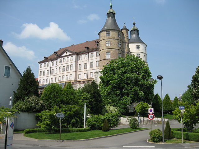

Montbéliard
- commune in Doubs, France
Hiking in Montbéliard
Montbéliard, a picturesque town located in the Bourgogne-Franche-Comté region of eastern France, offers various hiking opportunities that allow you to explore the beautiful landscapes and rich history of the area....
- Country:
- Postal Code: 25200
- Coordinates: 47° 30' 35" N, 6° 47' 54" E
- GPS tracks (wikiloc): [Link]
- AboveSeaLevel: 337 м m
- Area: 15.01 sq km
- Population: 25336
- Web site: [Link]


Bart
- commune in Doubs, France
Hiking in Bart
Hiking in Bart, a small commune in the Doubs department of France, offers a blend of beautiful landscapes, rich history, and the opportunity to experience the natural beauty of the Jura Mountains. Here’s what you need to know about hiking in this region:...
- Country:
- Postal Code: 25420
- Coordinates: 47° 29' 32" N, 6° 46' 17" E
- GPS tracks (wikiloc): [Link]
- Area: 3.84 sq km
- Population: 2022

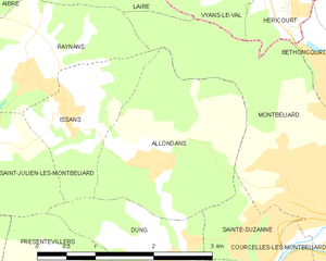
Allondans
- commune in Doubs, France
Hiking in Allondans
Allondans, a small village located in the Haute-Saône department of the Bourgogne-Franche-Comté region in eastern France, offers a range of hiking opportunities that showcase the scenic beauty of the surrounding countryside. While it might not be as famous as some other hiking destinations in France, its charm lies in its tranquil landscapes and local trails....
- Country:
- Postal Code: 25550
- Coordinates: 47° 31' 9" N, 6° 44' 51" E
- GPS tracks (wikiloc): [Link]
- Area: 5.14 sq km
- Population: 245


Courcelles-lès-Montbéliard
- commune in Doubs, France
Hiking in Courcelles-lès-Montbéliard
Courcelles-lès-Montbéliard is a charming village located in the Doubs department in the Bourgogne-Franche-Comté region of France. This area offers various hiking opportunities that cater to different skill levels and preferences....
- Country:
- Postal Code: 25420
- Coordinates: 47° 30' 0" N, 6° 47' 10" E
- GPS tracks (wikiloc): [Link]
- Area: 2.4 sq km
- Population: 1174


Dung
- commune in Doubs, France
Hiking in Dung
Dung, located in the Doubs department of the Bourgogne-Franche-Comté region in France, is often overlooked but offers some beautiful hiking opportunities. The Doubs region is characterized by its stunning landscapes, featuring valleys, rivers, lakes, and lush forests. Here are some key points to consider if you're planning to hike in Dung or the surrounding areas:...
- Country:
- Postal Code: 25550
- Coordinates: 47° 30' 17" N, 6° 45' 7" E
- GPS tracks (wikiloc): [Link]
- Area: 3.22 sq km
- Population: 662