Sallenôves (Sallenôves)

- commune in Haute-Savoie, France
 Hiking in Sallenôves
Sallenôves is a small commune located in the Auvergne-Rhône-Alpes region of southeastern France. While it may not be as widely known as some of the larger hiking destinations in the Alps, it offers a charming rural landscape and opportunities for outdoor activities.
Hiking Trails:
-
Scenic Routes: The area around Sallenôves features a variety of trails, primarily through picturesque countryside and around fields, forests, and small hills. You can expect to encounter beautiful views of the surrounding mountains and rich flora and fauna.
-
Local Trails: There may be smaller, less formal trails that locals use for walking and biking. These can often be found leading through farmlands or along forested areas. Consult local maps or tourism offices for more precise trail information.
-
Nearby Options: If you're looking for more extensive or challenging hikes, the nearby Chartreuse Mountains and the pre-Alps offer many well-marked trails. Popular areas include the Vercors Regional Natural Park or the Chartreuse Regional Natural Park, both of which provide a wide variety of hiking options from family walks to more strenuous climbs.
Tips for Hiking in Sallenôves:
- Weather Awareness: Always check the weather conditions before heading out, as they can change quickly in mountainous regions.
- Prepare for Terrain: Wear sturdy hiking boots and bring appropriate gear. The terrain can vary, and being prepared can enhance your experience.
- Local Resources: Visit the local tourism office for maps, trail recommendations, and any seasonal variations in trail accessibility.
- Wildlife & Nature: Be respectful of wildlife and nature. Stay on marked trails and practice Leave No Trace principles.
- Duration & Difficulty: Tailor your hikes to your ability level and time available, keeping in mind that some trails may be more challenging than others.
Conclusion:
While Sallenôves may not be a major hiking destination, its charm and proximity to larger hiking regions make it a delightful spot to enjoy the great outdoors. Whether you're seeking a leisurely stroll or a more intensive hike, you can find enjoyable trails and beautiful scenery in this part of France.
- Country:

- Postal Code: 74270
- Coordinates: 46° 0' 20" N, 5° 59' 56" E


- GPS tracks (wikiloc): [Link]
- Area: 3.64 sq km
- Population: 649
- Web site: http://sallenoves.fr
- Wikipedia en: wiki(en)
- Wikipedia: wiki(fr)
- Wikidata storage: Wikidata: Q772588
- Wikipedia Commons Category: [Link]
- Freebase ID: [/m/03ntyny]
- GeoNames ID: Alt: [6443047]
- SIREN number: [217402577]
- BnF ID: [15274511n]
- VIAF ID: Alt: [306264950]
- INSEE municipality code: 74257
Shares border with regions:

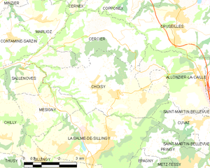
Choisy, Haute-Savoie
- commune in Haute-Savoie, France
Hiking in Choisy, Haute-Savoie
Choisy, located in the Haute-Savoie department in the Auvergne-Rhône-Alpes region of France, offers stunning hiking opportunities amid the picturesque landscapes of the French Alps. Here are some highlights and tips for hiking in Choisy:...
- Country:
- Postal Code: 74330
- Coordinates: 45° 59' 34" N, 6° 3' 27" E
- GPS tracks (wikiloc): [Link]
- Area: 16.57 sq km
- Population: 1558
- Web site: [Link]


Marlioz
- commune in Haute-Savoie, France
Hiking in Marlioz
Marlioz, located in the Haute-Savoie region of France, is known for its stunning natural beauty and outdoor activities, including hiking. The area is characterized by its picturesque landscapes, featuring mountains, lush forests, and serene lakes....
- Country:
- Postal Code: 74270
- Coordinates: 46° 1' 55" N, 6° 0' 13" E
- GPS tracks (wikiloc): [Link]
- Area: 8.12 sq km
- Population: 924
- Web site: [Link]


Chilly
- commune in Haute-Savoie, France
Hiking in Chilly
Chilly is a charming commune in the Haute-Savoie region of France, located near the beautiful French Alps. This area offers a variety of hiking opportunities for both casual walkers and more experienced trekkers. Here are some highlights about hiking in and around Chilly:...
- Country:
- Postal Code: 74270
- Coordinates: 45° 59' 30" N, 5° 57' 10" E
- GPS tracks (wikiloc): [Link]
- Area: 18.58 sq km
- Population: 1281

Contamine-Sarzin
- commune in Haute-Savoie, France
Hiking in Contamine-Sarzin
Contamine-Sarzin is a charming village located in the French Alps, situated within the Haute-Savoie region. It offers a range of hiking paths that provide stunning views of the surrounding mountains and lush landscapes. Here are some details to consider when hiking in this area:...
- Country:
- Postal Code: 74270
- Coordinates: 46° 1' 28" N, 5° 58' 56" E
- GPS tracks (wikiloc): [Link]
- Area: 6.86 sq km
- Population: 681
- Web site: [Link]

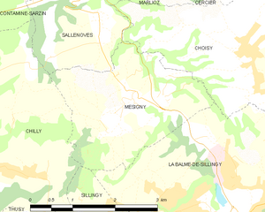
Mésigny
- commune in Haute-Savoie, France
Hiking in Mésigny
Mésigny, a charming village located in the Auvergne-Rhône-Alpes region of France, offers a variety of hiking opportunities that showcase the region's natural beauty. While the village itself is small, the surrounding area features beautiful landscapes, rolling hills, and scenic views that are perfect for outdoor enthusiasts....
- Country:
- Postal Code: 74330
- Coordinates: 45° 59' 8" N, 6° 0' 10" E
- GPS tracks (wikiloc): [Link]
- Area: 6.73 sq km
- Population: 689
- Web site: [Link]