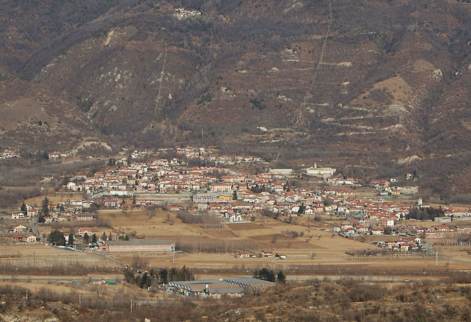
San Didero (San Didero)

- Italian comune
 Hiking in San Didero
It seems there might be a mix-up with the name "San Didero," as it doesn’t correspond to a well-known hiking destination. However, if you meant a different location—such as San Didero in Italy or perhaps a nearby area—please let me know!
If you are looking for general hiking information, here are some tips and things to consider for hiking in mountainous or nature areas:
-
Trail Selection: Choose a trail that matches your skill level and physical condition. There are often a variety of trails ranging from easy to difficult.
-
Weather Conditions: Before heading out, check the weather forecast. Conditions can change rapidly in mountainous areas, so be prepared for rain or colder temperatures.
-
Safety Gear: Always wear appropriate footwear and carry essential gear, including a first aid kit, water, snacks, a map, and a compass or GPS device.
-
Leave No Trace: Respect nature by following Leave No Trace principles. Pack out what you pack in, stay on trails, and avoid disturbing wildlife.
-
Inform Someone: Let someone know your hiking plan, including your intended route and estimated return time.
-
Wildlife Awareness: Be aware of the wildlife in the area and how to respond quickly in case of an encounter.
If you were indeed referring to a specific trail or region, please provide more details for tailored information!
- Country:

- Postal Code: 10050
- Local Dialing Code: 011
- Licence Plate Code: TO
- Coordinates: 45° 8' 0" N, 7° 13' 0" E


- GPS tracks (wikiloc): [Link]
- AboveSeaLevel: 430 м m
- Area: 3.3 sq km
- Population: 537
- Web site: http://www.comune.sandidero.to.it
- Wikipedia en: wiki(en)
- Wikipedia: wiki(it)
- Wikidata storage: Wikidata: Q10262
- Wikipedia Commons Category: [Link]
- Freebase ID: [/m/0g8ll8]
- GeoNames ID: Alt: [6543264]
- VIAF ID: Alt: [236997161]
- OSM relation ID: [44265]
- Digital Atlas of the Roman Empire ID: [17125]
- ISTAT ID: 001239
- Italian cadastre code: H820
Shares border with regions:


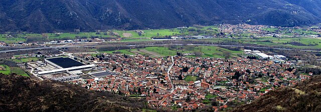
San Giorio di Susa
- Italian comune
Hiking in San Giorio di Susa
San Giorio di Susa is a charming village located in the Susa Valley of the Piedmont region in northern Italy. Nestled in the foothills of the Alps, it offers a variety of hiking opportunities that cater to different skill levels and preferences....
- Country:
- Postal Code: 10050
- Local Dialing Code: 0122
- Licence Plate Code: TO
- Coordinates: 45° 8' 0" N, 7° 10' 0" E
- GPS tracks (wikiloc): [Link]
- Area: 19.74 sq km
- Population: 996
- Web site: [Link]


Villar Focchiardo
- Italian comune
Hiking in Villar Focchiardo
Villar Focchiardo is a beautiful destination for hiking enthusiasts located in the Piedmont region of Italy, not far from the larger city of Turin. This area is characterized by its stunning natural landscapes, including lush valleys, rolling hills, and various flora and fauna. Here’s what you need to know about hiking in Villar Focchiardo:...
- Country:
- Postal Code: 10050
- Local Dialing Code: 011
- Licence Plate Code: TO
- Coordinates: 45° 7' 0" N, 7° 14' 0" E
- GPS tracks (wikiloc): [Link]
- Area: 25.69 sq km
- Population: 1987
- Web site: [Link]


Borgone Susa
- Italian comune
Hiking in Borgone Susa
Borgone Susa is a charming village located in the Susa Valley in the Piedmont region of Italy. Surrounded by the breathtaking peaks of the Alps, it offers a variety of hiking opportunities that cater to different skill levels, making it an ideal destination for both beginner and experienced hikers....
- Country:
- Postal Code: 10050
- Local Dialing Code: 011
- Licence Plate Code: TO
- Coordinates: 45° 7' 23" N, 7° 14' 28" E
- GPS tracks (wikiloc): [Link]
- AboveSeaLevel: 394 м m
- Area: 4.96 sq km
- Population: 2205
- Web site: [Link]

Bruzolo
- Italian comune
Hiking in Bruzolo
Bruzolo is a charming village located in the Susa Valley in the Piedmont region of Italy. It offers beautiful landscapes, rich history, and various hiking opportunities that attract outdoor enthusiasts....
- Country:
- Postal Code: 10050
- Local Dialing Code: 011
- Licence Plate Code: TO
- Coordinates: 45° 9' 0" N, 7° 12' 0" E
- GPS tracks (wikiloc): [Link]
- AboveSeaLevel: 455 м m
- Area: 12.56 sq km
- Population: 1533
- Web site: [Link]

Condove
- Italian comune
Hiking in Condove
Condove is a small town located in the Susa Valley, within the Piedmont region of Italy. It's surrounded by stunning natural scenery, making it a wonderful spot for hiking and outdoor activities. The area is characterized by its picturesque landscapes, including the impressive peaks of the Susa Alps....
- Country:
- Postal Code: 10055
- Local Dialing Code: 011
- Licence Plate Code: TO
- Coordinates: 45° 7' 0" N, 7° 19' 0" E
- GPS tracks (wikiloc): [Link]
- AboveSeaLevel: 376 м m
- Area: 71.11 sq km
- Population: 4614
- Web site: [Link]