
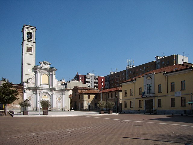
San Donato Milanese (San Donato Milanese)
.svg)
- Italian comune
 Hiking in San Donato Milanese
San Donato Milanese, located just south of Milan, is primarily known as a residential and business district rather than a hiking destination. However, there are various options for outdoor lovers in and around the area.
Nearby Parks and Natural Areas
-
Parco della Vettabbia: This park is a large green space near San Donato Milanese that offers walking and biking paths along the Vettabbia River. It’s suitable for leisurely hikes and enjoying nature without venturing too far from urban amenities.
-
Parco Nord Milano: Located a bit further north, this extensive park provides numerous trails for walking and cycling amidst lush greenery and is a popular spot for local residents.
-
Navigli’s Greenways: The Navigli canals have scenic paths along their banks. You can enjoy a pleasant stroll or bike ride that connects to various points within Milan.
Hiking Options
Although San Donato itself does not have extensive hiking options, consider taking short trips to nearby regions:
- Monte Resegone: Located about an hour away, this mountain offers several hiking trails with varying difficulty levels and stunning views of the surrounding area.
- Parco Regionale della Valle del Lambro: This regional park is about a 30-minute drive from San Donato and offers beautiful forested trails and the chance to experience the natural beauty of the Lombardy region.
Tips for Hiking in the Area
- Gear Up: Always wear appropriate hiking shoes and carry water, snacks, and a first aid kit.
- Check Conditions: Be mindful of the weather and trail conditions before heading out.
- Stay Safe: If hiking in remote areas, let someone know your plans and expected return time.
Local Culture
While hiking, you might also enjoy the charm of local cafés and restaurants to refuel after your adventure. San Donato Milanese itself has various dining options where you can experience local cuisine.
In summary, while San Donato Milanese may not be a premier hiking location, it offers access to several green spaces and is well-positioned for exploring the rich variety of hiking trails in the surrounding Lombardy area. Enjoy your outdoor adventures!
- Country:

- Postal Code: 20097
- Local Dialing Code: 02
- Licence Plate Code: MI
- Coordinates: 45° 25' 0" N, 9° 16' 0" E


- GPS tracks (wikiloc): [Link]
- AboveSeaLevel: 102 м m
- Area: 12.88 sq km
- Population: 32416
- Web site: http://www.comune.sandonatomilanese.mi.it/
- Wikipedia en: wiki(en)
- Wikipedia: wiki(it)
- Wikidata storage: Wikidata: Q42192
- Wikipedia Commons Gallery: [Link]
- Wikipedia Commons Category: [Link]
- Freebase ID: [/m/0gj7ct]
- GeoNames ID: Alt: [6537131]
- VIAF ID: Alt: [152615503]
- OSM relation ID: [44900]
- archINFORM location ID: [978]
- MusicBrainz area ID: [13c1fa30-952a-45c7-b912-18874e7561bf]
- Quora topic ID: [San-Donato-Milanese]
- UN/LOCODE: [ITSDE]
- ISTAT ID: 015192
- Italian cadastre code: H827
Shares border with regions:
Mediglia
- Italian comune
Hiking in Mediglia
Mediglia is a small town located in the Lombardy region of Italy, near Milan. While it may not be as famous for hiking as the nearby mountainous areas like the Italian Alps or the Appennines, there are still opportunities for outdoor walks and exploration in and around Mediglia....
- Country:
- Postal Code: 20060
- Local Dialing Code: 02
- Licence Plate Code: MI
- Coordinates: 45° 24' 0" N, 9° 20' 0" E
- GPS tracks (wikiloc): [Link]
- AboveSeaLevel: 95 м m
- Area: 21.96 sq km
- Population: 12198
- Web site: [Link]

San Giuliano Milanese
- Italian comune
Hiking in San Giuliano Milanese
San Giuliano Milanese, located just southeast of Milan, Italy, may not be the first destination that comes to mind when thinking about hiking. However, the surrounding areas and nearby parks offer several opportunities for outdoor activities and enjoyable walks....
- Country:
- Postal Code: 20098
- Local Dialing Code: 02
- Licence Plate Code: MI
- Coordinates: 45° 24' 0" N, 9° 17' 0" E
- GPS tracks (wikiloc): [Link]
- AboveSeaLevel: 97 м m
- Area: 30.87 sq km
- Population: 38318
- Web site: [Link]
Opera
- Italian comune
Hiking in Opera
Hiking in Opera, a small town in the Lombardy region of Italy, offers a unique blend of natural beauty and cultural experiences. While Opera itself is not immediately known for extensive hiking trails, it is situated near the metropolitan area of Milan and surrounded by several beautiful parks and nature reserves that provide excellent opportunities for outdoor activities....
- Country:
- Postal Code: 20090
- Local Dialing Code: 02
- Licence Plate Code: MI
- Coordinates: 45° 23' 0" N, 9° 13' 0" E
- GPS tracks (wikiloc): [Link]
- AboveSeaLevel: 99 м m
- Area: 7.64 sq km
- Population: 13783
- Web site: [Link]
Locate di Triulzi
- Italian comune
Hiking in Locate di Triulzi
Locate di Triulzi, located in the Metropolitan City of Milan, Italy, is not typically known as a hiking destination due to its urban and suburban characteristics. However, there are some opportunities for outdoor activities in and around the area, particularly if you're willing to explore nearby parks and green spaces....
- Country:
- Postal Code: 20085
- Local Dialing Code: 02
- Licence Plate Code: MI
- Coordinates: 45° 21' 0" N, 9° 13' 0" E
- GPS tracks (wikiloc): [Link]
- AboveSeaLevel: 150 м m
- Area: 12.61 sq km
- Population: 10216
- Web site: [Link]


Peschiera Borromeo
- Italian comune
Hiking in Peschiera Borromeo
Peschiera Borromeo, located just southeast of Milan in Italy, is not primarily known for its extensive hiking trails compared to larger natural parks or mountainous regions. However, the area does offer some opportunities for leisurely walks and hikes, particularly in its green spaces and along the nearby waterways....
- Country:
- Postal Code: 20068
- Local Dialing Code: 02
- Licence Plate Code: MI
- Coordinates: 45° 26' 0" N, 9° 19' 0" E
- GPS tracks (wikiloc): [Link]
- AboveSeaLevel: 107 м m
- Area: 23.22 sq km
- Population: 23515
- Web site: [Link]
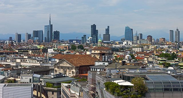

Milan
- second-largest city in Italy
Hiking in Milan
Hiking in and around Milan offers a unique blend of urban and natural experiences. While Milan itself is a bustling metropolitan area, it is also well-positioned near several excellent hiking spots in the surrounding regions. Here are some noteworthy areas and tips for hiking near Milan:...
- Country:
- Postal Code: 20162; 20161; 20159; 20158; 20157; 20156; 20155; 20154; 20153; 20152; 20151; 20149; 20148; 20147; 20146; 20145; 20144; 20143; 20142; 20141; 20139; 20138; 20137; 20136; 20135; 20134; 20133; 20132; 20131; 20129; 20128; 20127; 20126; 20125; 20124; 20123; 20122; 20121
- Local Dialing Code: 02
- Licence Plate Code: MI
- Coordinates: 45° 27' 51" N, 9° 11' 25" E
- GPS tracks (wikiloc): [Link]
- AboveSeaLevel: 120 м m
- Area: 181.67 sq km
- Population: 1351562
- Web site: [Link]