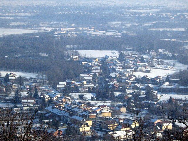
San Gillio (San Gillio)

- Italian comune
 Hiking in San Gillio
San Gillio, located in the Piedmont region of northern Italy near Turin, offers several beautiful hiking opportunities for outdoor enthusiasts. The area is characterized by its picturesque landscapes, lush forests, and rolling hills, making it a perfect spot for both beginner and experienced hikers.
Hiking Trails
-
Parco Naturale La Mandria: Close to San Gillio, this park features well-marked trails for various skill levels. You can enjoy walking through beautifully preserved natural landscapes, spotting wildlife, and discovering historical sites like the Royal Palace of Venaria.
-
Monte Musinè: A bit more challenging, this mountain offers trails that reward hikers with stunning views of the surrounding valleys and the Alps. The trails can be steep in places, so a good level of fitness is recommended.
-
Sentiero dei Cuni: This scenic route provides a mix of easy to moderate terrain and is suitable for families. The trail meanders through scenic farmland and vineyards, providing a glimpse of the local culture along the way.
Tips for Hiking in San Gillio
- Season: The best times for hiking are typically spring (April to June) and fall (September to October) when the temperatures are mild, and the landscapes are vibrant.
- Preparation: Always wear appropriate shoes, bring plenty of water, and consider packing snacks. A map or a trail guide can be very helpful as cell service may be limited in remote areas.
- Local Regulations: Be aware of local regulations regarding nature conservation. Stick to marked trails and respect wildlife and natural habitats.
- Guided Tours: If you’re new to the area or want to learn more about the region, consider joining a guided hiking tour. Local guides can provide valuable insights into the flora, fauna, and history of San Gillio and its surroundings.
Accessibility
San Gillio is easily accessible from Turin, making it a convenient destination for a day hike. Public transport options such as bus services can get you close to trailheads.
Key Consideration
As always, keep an eye on weather conditions before heading out, as they can change rapidly in mountain areas. Let someone know your hiking plans and estimated return time for safety.
If you're ready for an adventure, San Gillio's natural beauty is waiting for you to explore! Enjoy your hike!
- Country:

- Postal Code: 10040
- Local Dialing Code: 011
- Licence Plate Code: TO
- Coordinates: 45° 9' 0" N, 7° 32' 0" E


- GPS tracks (wikiloc): [Link]
- AboveSeaLevel: 320 м m
- Area: 8.89 sq km
- Population: 3166
- Web site: http://www.comune.sangillio.to.it
- Wikipedia en: wiki(en)
- Wikipedia: wiki(it)
- Wikidata storage: Wikidata: Q10265
- Wikipedia Commons Category: [Link]
- Freebase ID: [/m/0g8lnt]
- GeoNames ID: Alt: [6540665]
- OSM relation ID: [44270]
- TGN ID: [7041726]
- UN/LOCODE: [ITIIO]
- ISTAT ID: 001243
- Italian cadastre code: H873
Shares border with regions:


Val della Torre
- Italian comune
Hiking in Val della Torre
Val della Torre is a beautiful valley located in the Piedmont region of Italy, near the city of Turin. It's known for its diverse landscapes, ranging from lush forests to rocky mountain terrains, making it an appealing destination for hikers and nature enthusiasts. Here are some key points to consider when hiking in Val della Torre:...
- Country:
- Postal Code: 10040
- Local Dialing Code: 011
- Licence Plate Code: TO
- Coordinates: 45° 9' 19" N, 7° 26' 42" E
- GPS tracks (wikiloc): [Link]
- AboveSeaLevel: 505 м m
- Area: 36.53 sq km
- Population: 3892
- Web site: [Link]


Alpignano
- Italian comune in the Province of Turin in the Piedmont
Hiking in Alpignano
Alpignano, located in the Piedmont region of Italy, near Turin, offers several hiking opportunities for nature lovers and outdoor enthusiasts. The area is characterized by its picturesque landscapes, rolling hills, and proximity to the larger Susa Valley and the Italian Alps, making it a great starting point for various hiking trails....
- Country:
- Postal Code: 10091
- Local Dialing Code: 011
- Licence Plate Code: TO
- Coordinates: 45° 6' 0" N, 7° 31' 0" E
- GPS tracks (wikiloc): [Link]
- AboveSeaLevel: 330 м m
- Area: 11.92 sq km
- Population: 16679
- Web site: [Link]


Druento
- Italian comune
Hiking in Druento
Druento is a charming municipality in the Piedmont region of Italy, known for its proximity to the beautiful natural landscapes of the Susa Valley and the nearby mountains. While it may not be a major hiking destination like some of the surrounding areas, it offers several opportunities for outdoor activities and nature walks....
- Country:
- Postal Code: 10040
- Local Dialing Code: 011
- Licence Plate Code: TO
- Coordinates: 45° 8' 0" N, 7° 35' 0" E
- GPS tracks (wikiloc): [Link]
- AboveSeaLevel: 285 м m
- Area: 27.54 sq km
- Population: 8790
- Web site: [Link]

Givoletto
- Italian comune
Hiking in Givoletto
Givoletto is a charming town located near Turin, in the Piedmont region of Italy. It's an excellent base for hiking, with access to beautiful landscapes, exposed trails, and the scenic foothills of the Alps. Here are some highlights and tips for hiking in and around Givoletto:...
- Country:
- Postal Code: 10040
- Local Dialing Code: 011
- Licence Plate Code: TO
- Coordinates: 45° 10' 0" N, 7° 30' 0" E
- GPS tracks (wikiloc): [Link]
- AboveSeaLevel: 400 м m
- Area: 12.82 sq km
- Population: 3953
- Web site: [Link]


La Cassa
- Italian comune
Hiking in La Cassa
La Cassa is a small municipality in the Piedmont region of northern Italy, situated near the larger city of Turin. While it may not be as widely recognized as a hiking destination compared to more prominent areas in the Italian Alps, it is surrounded by beautiful landscapes and offers opportunities for hiking enthusiasts to explore the natural beauty of the region....
- Country:
- Postal Code: 10040
- Local Dialing Code: 011
- Licence Plate Code: TO
- Coordinates: 45° 10' 52" N, 7° 31' 2" E
- GPS tracks (wikiloc): [Link]
- AboveSeaLevel: 374 м m
- Area: 12.04 sq km
- Population: 1825
- Web site: [Link]

Pianezza
- Italian comune
Hiking in Pianezza
Pianezza, located in the Piedmont region of Italy, offers a range of hiking opportunities that showcase its beautiful natural landscapes and proximity to the Susa Valley and the larger Alps. Here are some details you might find useful if you are considering hiking in this area:...
- Country:
- Postal Code: 10044
- Local Dialing Code: 011
- Licence Plate Code: TO
- Coordinates: 45° 6' 15" N, 7° 33' 0" E
- GPS tracks (wikiloc): [Link]
- AboveSeaLevel: 365 м m
- Area: 16.5 sq km
- Population: 15309
- Web site: [Link]