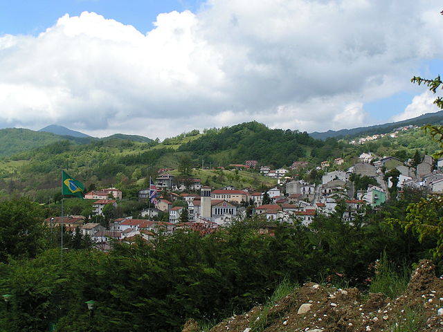
San Pietro Avellana (San Pietro Avellana)
.svg)
- Italian comune
 Hiking in San Pietro Avellana
San Pietro Avellana is a charming village located in the Molise region of Italy, surrounded by the scenic landscapes of the Apennines. The area offers numerous opportunities for hiking enthusiasts to explore its natural beauty, rich flora and fauna, and stunning views.
Hiking Trails
-
Sentiero della Botte: This trail takes you through beautiful woodlands and offers breathtaking views of the surrounding mountains. It’s a moderate hike, suitable for those looking for a serene experience immersed in nature.
-
Path to Monte Campo: This trail leads you up to Monte Campo, providing a more challenging hike for experienced trekkers. The ascent is rewarded with panoramic views of the surrounding countryside.
-
The Valley of the Rivers: A less-traveled route that takes you alongside rivers and streams, perfect for those looking for a quieter hike. Keep an eye out for local wildlife along the way.
Tips for Hiking in San Pietro Avellana
- Season: Spring and early autumn are generally the best times for hiking, with mild temperatures and vibrant scenery.
- Gear: Wear sturdy hiking boots, carry water, and use trekking poles if desired. Always check the weather forecast before heading out.
- Maps: It’s advisable to get a local trail map or use a hiking app to keep track of your route.
- Local Guides: Consider hiring a local guide, especially if you want to learn about the area’s biodiversity or history.
- Respect Nature: Follow the principles of Leave No Trace to maintain the area’s beauty and ecological health.
Nearby Attractions
- Castello di San Pietro Avellana: Explore the historical castle in the village, which adds a cultural touch to your hiking adventure.
- Local Cuisine: After a long hike, enjoy some traditional Molise cuisine at a local trattoria, where you can sample dishes made from fresh, local ingredients.
Whether you're seeking a leisurely stroll or a more intense trek, San Pietro Avellana offers a diverse hiking experience set in a picturesque Italian landscape. Happy hiking!
- Country:

- Postal Code: 86088
- Local Dialing Code: 0865
- Licence Plate Code: IS
- Coordinates: 41° 47' 31" N, 14° 10' 53" E


- GPS tracks (wikiloc): [Link]
- AboveSeaLevel: 960 м m
- Area: 44.95 sq km
- Population: 515
- Web site: http://www.comune.sanpietroavellana.is.it/
- Wikipedia en: wiki(en)
- Wikipedia: wiki(it)
- Wikidata storage: Wikidata: Q279587
- Wikipedia Commons Category: [Link]
- Freebase ID: [/m/0gq_wm]
- GeoNames ID: Alt: [6537955]
- VIAF ID: Alt: [247850132]
- OSM relation ID: [41552]
- ISTAT ID: 094043
- Italian cadastre code: I096
Shares border with regions:


Capracotta
- Italian comune
Hiking in Capracotta
Capracotta, located in the Apennine Mountains of Italy, is a delightful destination for hiking enthusiasts. This charming mountain town is situated in the Molise region and offers breathtaking landscapes, rich biodiversity, and a network of well-marked trails suitable for various skill levels....
- Country:
- Postal Code: 86082
- Local Dialing Code: 0865
- Licence Plate Code: IS
- Coordinates: 41° 50' 0" N, 14° 16' 0" E
- GPS tracks (wikiloc): [Link]
- AboveSeaLevel: 1421 м m
- Area: 42.55 sq km
- Population: 874
- Web site: [Link]
Castel del Giudice
- Italian comune
Hiking in Castel del Giudice
Castel del Giudice, located in the province of Isernia in the Molise region of Italy, is a picturesque village nestled in the Apennine Mountains. The area is known for its stunning landscapes, rich history, and outdoor recreational opportunities, making it an excellent destination for hiking enthusiasts....
- Country:
- Postal Code: 86080
- Local Dialing Code: 0865
- Licence Plate Code: IS
- Coordinates: 41° 51' 0" N, 14° 14' 0" E
- GPS tracks (wikiloc): [Link]
- AboveSeaLevel: 800 м m
- Area: 14.81 sq km
- Population: 324
- Web site: [Link]


Vastogirardi
- Italian comune
Hiking in Vastogirardi
Vastogirardi is a delightful hidden gem located in the Molise region of Italy, known for its stunning landscapes, rich history, and outdoor recreational opportunities. Here are some highlights of hiking in Vastogirardi:...
- Country:
- Postal Code: 86089
- Local Dialing Code: 0865
- Licence Plate Code: IS
- Coordinates: 41° 46' 0" N, 14° 16' 0" E
- GPS tracks (wikiloc): [Link]
- AboveSeaLevel: 1200 м m
- Area: 60.71 sq km
- Population: 684
- Web site: [Link]

Ateleta
- Italian comune
Hiking in Ateleta
Ateleta, a charming town in the Abruzzo region of Italy, offers beautiful hiking opportunities characterized by stunning landscapes, picturesque views, and diverse trails. The surrounding area is part of the larger Maiella National Park, which is known for its rich biodiversity, rugged mountain terrain, and scenic vistas....
- Country:
- Postal Code: 67030
- Local Dialing Code: 0864
- Licence Plate Code: AQ
- Coordinates: 41° 51' 16" N, 14° 11' 56" E
- GPS tracks (wikiloc): [Link]
- AboveSeaLevel: 760 м m
- Area: 41.93 sq km
- Population: 1156
- Web site: [Link]


Castel di Sangro
- Italian comune
Hiking in Castel di Sangro
Castel di Sangro is located in the Abruzzo region of Italy and is known for its stunning natural landscapes, rich history, and proximity to the Abruzzo, Lazio, and Molise National Park. Hiking in this area offers a variety of trails that cater to different skill levels, making it a great destination for both novice and experienced hikers....
- Country:
- Postal Code: 67031
- Local Dialing Code: 0864
- Licence Plate Code: AQ
- Coordinates: 41° 47' 3" N, 14° 6' 31" E
- GPS tracks (wikiloc): [Link]
- AboveSeaLevel: 805 м m
- Area: 84.44 sq km
- Population: 6705
- Web site: [Link]


Roccaraso
- place and commune in Italy
Hiking in Roccaraso
Roccaraso is a charming destination in the Apennine Mountains, located in the Abruzzo region of central Italy. Famous for its ski resorts in winter, it's also a fantastic location for hiking during the warmer months. Here are some key points to consider if you’re planning a hiking adventure in Roccaraso:...
- Country:
- Postal Code: 67037
- Local Dialing Code: 0864
- Licence Plate Code: AQ
- Coordinates: 41° 50' 48" N, 14° 4' 43" E
- GPS tracks (wikiloc): [Link]
- AboveSeaLevel: 1236 м m
- Area: 49.91 sq km
- Population: 1702
- Web site: [Link]