San Pietro Val Lemina (San Pietro Val Lemina)

- Italian comune
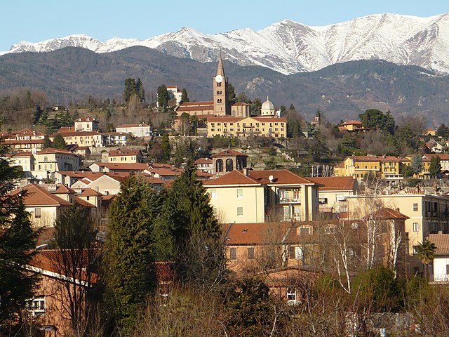
 Hiking in San Pietro Val Lemina
San Pietro Val Lemina, located in the Piedmont region of Italy, offers a beautiful setting for hiking enthusiasts. Nestled within the Susa Valley, it is surrounded by stunning natural landscapes, including rolling hills, forests, and mountain views.
Hiking Trails:
-
Local Trails: There are several marked trails around San Pietro Val Lemina that cater to various fitness levels. Many of these trails take you through lush woodlands and offer panoramic views of the valley and surrounding mountains.
-
Val di Susa Trails: The nearby Val di Susa also features an extensive network of hiking trails, ranging from easy walks to more challenging treks. You can explore paths that lead to historic sites, alpine meadows, and breathtaking viewpoints.
-
Sentiero dei Parchi: This long-distance trail connects several parks in the area, providing an opportunity for multi-day hikes if you prefer a more extended adventure.
What to Expect:
- Scenic Beauty: Expect to encounter rich biodiversity, picturesque landscapes, and quaint villages along the way.
- Wildlife Viewing: Hikers may spot various wildlife, including birds and other animals typical of the Piedmont region.
- Cultural Experience: Many trails lead to historic landmarks, such as old churches and ruins, offering a glimpse into the area's cultural heritage.
Preparation Tips:
- Check the Weather: Conditions can change quickly in mountainous regions, so it’s essential to check the weather forecast.
- Pack Proper Gear: Wear appropriate hiking boots and dress in layers to ensure comfort throughout your hike.
- Stay Hydrated: Bring enough water and snacks, especially for longer hikes.
- Maps and Route Planning: It's advisable to have a map of the area or a hiking app for navigation.
Best Time to Hike:
The best time for hiking in San Pietro Val Lemina is during the late spring (May to June) and early autumn (September to October) when the weather is mild, and the landscape is particularly beautiful.
Conclusion:
San Pietro Val Lemina is an inviting destination for hikers of all skill levels. Whether you’re looking for a quick day hike or a more extended trek through the stunning scenery of Northern Italy, you’ll find plenty of opportunities to enjoy the great outdoors here.
- Country:

- Postal Code: 10060
- Local Dialing Code: 0121
- Licence Plate Code: TO
- Coordinates: 44° 55' 0" N, 7° 19' 0" E


- GPS tracks (wikiloc): [Link]
- AboveSeaLevel: 451 м m
- Area: 12.44 sq km
- Population: 1459
- Web site: http://www.comune.sanpietrovallemina.to.it
- Wikipedia en: wiki(en)
- Wikipedia: wiki(it)
- Wikidata storage: Wikidata: Q10277
- Wikipedia Commons Category: [Link]
- Freebase ID: [/m/0dfx49]
- GeoNames ID: Alt: [6543787]
- OSM relation ID: [43790]
- ISTAT ID: 001250
- Italian cadastre code: I090
Shares border with regions:


Porte
- comune (municipality) in the Province of Turin in the Italian region Piedmont
Hiking in Porte
Hiking in Porte, located in the Piedmont region of Italy, offers a wealth of opportunities for outdoor enthusiasts. Nestled in the Susa Valley and surrounded by the stunning peaks of the Alps, Porte is an excellent base for exploring the natural beauty of the area....
- Country:
- Postal Code: 10060
- Local Dialing Code: 0121
- Licence Plate Code: TO
- Coordinates: 44° 53' 13" N, 7° 16' 4" E
- GPS tracks (wikiloc): [Link]
- AboveSeaLevel: 427 м m
- Area: 4.45 sq km
- Population: 1058
- Web site: [Link]


Villar Perosa
- Italian comune
Hiking in Villar Perosa
Villar Perosa is a small town located in the province of Turin, in the Piedmont region of Italy. The area is known for its natural beauty and proximity to the Susa Valley and the surrounding mountains, making it a great destination for hiking enthusiasts....
- Country:
- Postal Code: 10069
- Local Dialing Code: 0121
- Licence Plate Code: TO
- Coordinates: 44° 55' 0" N, 7° 15' 0" E
- GPS tracks (wikiloc): [Link]
- AboveSeaLevel: 489 м m
- Area: 11.42 sq km
- Population: 4026
- Web site: [Link]


Pinasca
- Italian comune
Hiking in Pinasca
Pinasca, located in the Piedmont region of Italy, offers a wonderful experience for hikers and nature enthusiasts. Tucked away at the foot of the mountains, Pinasca provides access to beautiful landscapes, trails, and outdoor activities. Here are some highlights about hiking in this area:...
- Country:
- Postal Code: 10060
- Local Dialing Code: 0121
- Licence Plate Code: TO
- Coordinates: 44° 57' 0" N, 7° 14' 0" E
- GPS tracks (wikiloc): [Link]
- AboveSeaLevel: 560 м m
- Area: 34.72 sq km
- Population: 2964
- Web site: [Link]

Pinerolo
- Italian comune
Hiking in Pinerolo
Pinerolo, located in the Piedmont region of Italy, is surrounded by beautiful mountainous terrain, making it a fantastic destination for hiking enthusiasts. Here are some key points about hiking in Pinerolo:...
- Country:
- Postal Code: 10064
- Local Dialing Code: 0121
- Licence Plate Code: TO
- Coordinates: 44° 53' 0" N, 7° 20' 0" E
- GPS tracks (wikiloc): [Link]
- AboveSeaLevel: 376 м m
- Area: 50.34 sq km
- Population: 35947
- Web site: [Link]