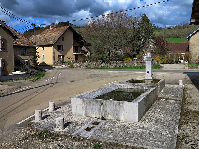
Sancey-le-Long (Sancey-le-Long)

- former commune in Doubs, France
 Hiking in Sancey-le-Long
Sancey-le-Long is a charming small town located in the Doubs department in the Bourgogne-Franche-Comté region of eastern France. It's surrounded by picturesque landscapes, making it a great destination for hiking enthusiasts looking to explore nature.
Here are some highlights and tips for hiking in and around Sancey-le-Long:
Trails and Scenery:
-
Varied Terrain: The area features a mix of terrains, including rolling hills, forests, and streams. You can find trails suitable for different skill levels, from easy walks to more challenging hikes.
-
Forests and Nature Reserves: The surrounding forests are ideal for hiking, providing shade and a chance to observe local flora and fauna. Look for trails that pass through nearby natural reserves.
-
Panoramic Views: Some trails offer stunning views over the countryside and the Doubs Valley. Be sure to bring your camera to capture the landscape.
Nearby Attractions:
- Sancey Castle Ruins: Explore historical sites that may offer nice walking paths around them.
- Lac de Saint-Point: This nearby lake is perfect for a longer hike, picnicking, or even swimming if the weather permits.
Tips for Hiking:
- Trail Maps: It’s advisable to carry detailed maps or download hiking apps to navigate the trails.
- Weather Preparedness: The weather can change quickly, so check forecasts and be prepared with the right gear.
- Stay Hydrated and Energized: Bring enough water and snacks, especially for longer hikes.
- Respect Nature: Stay on marked trails, pack out all trash, and respect the local wildlife.
Local Resources:
- Tourist Information: Stop by the local tourist office for maps, advice on trails, and information on guided hikes.
- Community Events: Keep an eye out for local hiking events or groups.
Enjoy your hiking adventure in Sancey-le-Long, and always prioritize safety while exploring the beautiful outdoors!
- Country:

- Postal Code: 25430
- Coordinates: 47° 18' 20" N, 6° 36' 8" E


- GPS tracks (wikiloc): [Link]
- Area: 7.02 sq km
- Population: 345
- Wikipedia en: wiki(en)
- Wikipedia: wiki(fr)
- Wikidata storage: Wikidata: Q906710
- Wikipedia Commons Category: [Link]
- Freebase ID: [/m/03mhcxs]
- Freebase ID: [/m/03mhcxs]
- GeoNames ID: Alt: [6429985]
- GeoNames ID: Alt: [6429985]
- BnF ID: [152527568]
- BnF ID: [152527568]
- PACTOLS thesaurus ID: [pcrtnZTYWLi1Yu]
- PACTOLS thesaurus ID: [pcrtnZTYWLi1Yu]
- INSEE municipality code: 25530
- INSEE municipality code: 25530
Shares border with regions:


Provenchère
- commune in Doubs, France
Hiking in Provenchère
Provenchère, located in the Doubs region of France, is a charming destination for hiking enthusiasts. Nestled in the picturesque Jura mountains, the area is known for its stunning landscapes, diverse ecosystems, and rich flora and fauna. Here are some key features about hiking in this region:...
- Country:
- Postal Code: 25380
- Coordinates: 47° 17' 21" N, 6° 38' 37" E
- GPS tracks (wikiloc): [Link]
- Area: 6.97 sq km
- Population: 134


Surmont
- commune in Doubs, France
Hiking in Surmont
Surmont, often referred to in the context of outdoor activities, typically relates to areas in Canada, particularly the Surmont oil sands project in Alberta. However, if you refer to hiking in the broader context or specific regions within Surmont or nearby areas, I can provide general guidance....
- Country:
- Postal Code: 25380
- Coordinates: 47° 16' 43" N, 6° 36' 40" E
- GPS tracks (wikiloc): [Link]
- Area: 7.38 sq km
- Population: 128


Belvoir
- commune in Doubs, France
Hiking in Belvoir
Belvoir, located in the Doubs department of France, offers some stunning hiking opportunities amidst picturesque landscapes. The area is characterized by rolling hills, dense forests, and beautiful viewpoints over the surrounding countryside....
- Country:
- Postal Code: 25430
- Coordinates: 47° 19' 3" N, 6° 36' 12" E
- GPS tracks (wikiloc): [Link]
- Area: 9.31 sq km
- Population: 105


Orve
- commune in Doubs, France
Hiking in Orve
Hiking in Orve, a scenic region in Switzerland, is a delightful experience for outdoor enthusiasts. The picturesque landscapes, characterized by rolling hills, lush forests, and stunning views of the Alps, provide a variety of trails suitable for all skill levels....
- Country:
- Postal Code: 25430
- Coordinates: 47° 19' 33" N, 6° 33' 14" E
- GPS tracks (wikiloc): [Link]
- Area: 5.51 sq km
- Population: 67
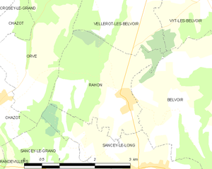
Rahon
- commune in Doubs, France
Hiking in Rahon
Rahon, located in the Doubs department of France, offers a beautiful setting for hiking enthusiasts. This region is known for its stunning landscapes, featuring rolling hills, forests, and scenic valleys. Here are some key points to consider when hiking in Rahon:...
- Country:
- Postal Code: 25430
- Coordinates: 47° 19' 21" N, 6° 35' 28" E
- GPS tracks (wikiloc): [Link]
- Area: 5.69 sq km
- Population: 128