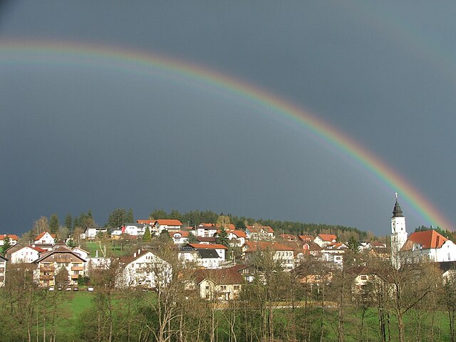
Sankt Aegidi (Sankt Aegidi)
- municipality in Austria
Sankt Aegidi, located in Austria, offers a variety of hiking opportunities that allow you to enjoy the stunning landscapes of the region. The area is characterized by its picturesque rolling hills, lush green meadows, and scenic views of the surrounding mountains.
Hiking Trails:
-
Local Trails: You can find well-marked local trails that vary in difficulty, suitable for both beginners and experienced hikers. Many of these trails wind through forests, past farms, and along rivers.
-
Panoramic Views: Some trails lead to vantage points that offer breathtaking views of the surrounding countryside, particularly beautiful in autumn when the foliage changes color.
-
Natural Parks: Nearby natural parks provide access to more extensive hiking routes, where you can immerse yourself in nature and potentially spot local wildlife.
Recommendations:
- Gear: Wear sturdy hiking boots and dress in layers, as weather can change quickly in mountainous areas.
- Water and Supplies: Bring plenty of water and snacks to stay energized during your hike.
- Maps and Apps: Use a hiking app or a physical map to navigate the trails, as mobile service can be spotty in remote areas.
Essentials:
- Best Season: Late spring through early autumn is typically the ideal time for hiking in the region, as temperatures are mild and trails are accessible.
- Guided Tours: If you're unfamiliar with the area, consider joining guided tours to learn more about the local wildlife and flora.
Whether you’re looking for a leisurely stroll or an invigorating hike, Sankt Aegidi has something to offer every outdoor enthusiast. Always check local conditions and trail updates before heading out, and enjoy the natural beauty of this charming region!
- Country:

- Postal Code: 4725
- Local Dialing Code: 07717
- Licence Plate Code: SD
- Coordinates: 48° 29' 0" N, 13° 44' 0" E


- GPS tracks (wikiloc): [Link]
- AboveSeaLevel: 599 м m
- Area: 29 sq km
- Population: 1556
- Web site: http://www.st-aegidi.at/
- Wikipedia en: wiki(en)
- Wikipedia: wiki(de)
- Wikidata storage: Wikidata: Q684547
- Wikipedia Commons Category: [Link]
- Freebase ID: [/m/03gvbpw]
- GeoNames ID: Alt: [7872131]
- VIAF ID: Alt: [314866549]
- Austrian municipality key: [41417]
Shares border with regions:

Engelhartszell an der Donau
- municipality in Austria
 Hiking in Engelhartszell an der Donau
Engelhartszell an der Donau, located in the Austrian region of Upper Austria, is a charming destination for hikers and nature enthusiasts. It’s nestled along the banks of the Danube River and offers a variety of scenic trails that showcase the natural beauty of the area....
- Country:

- Postal Code: 4090
- Local Dialing Code: 07717
- Licence Plate Code: SD
- Coordinates: 48° 30' 0" N, 13° 44' 0" E


- GPS tracks (wikiloc): [Link]
- AboveSeaLevel: 302 м m
- Area: 19 sq km
- Population: 942
- Web site: [Link]

Neukirchen am Walde
- municipality in Austria
Neukirchen am Walde is a charming municipality located in Bavaria, Germany, nestled in the picturesque landscape of the Bavarian Forest. This region offers a variety of hiking opportunities for both beginners and seasoned hikers. Here are some highlights of hiking in Neukirchen am Walde:...
- Country:

- Postal Code: 4724
- Local Dialing Code: 07278
- Licence Plate Code: GR
- Coordinates: 48° 24' 21" N, 13° 46' 55" E


- GPS tracks (wikiloc): [Link]
- AboveSeaLevel: 555 м m
- Area: 15.8 sq km
- Population: 1633
- Web site: [Link]

Natternbach
- municipality in Austria
Natternbach is a picturesque village located in the Upper Austria region, surrounded by beautiful natural scenery, making it a great spot for hiking enthusiasts. Here are some insights into hiking in and around Natternbach:...
- Country:

- Postal Code: 4723
- Local Dialing Code: 07278
- Licence Plate Code: GR
- Coordinates: 48° 23' 51" N, 13° 45' 0" E


- GPS tracks (wikiloc): [Link]
- AboveSeaLevel: 434 м m
- Area: 30.9 sq km
- Population: 2305
- Web site: [Link]


Waldkirchen am Wesen
- municipality in Austria
 Hiking in Waldkirchen am Wesen
Waldkirchen am Wesen is a charming village located in the beautiful region of Austria, specifically in the Upper Austria province. Nestled among the rolling hills and lush forests, it provides a fantastic backdrop for hikers of all levels. Here are some highlights and tips for hiking in this scenic area:...
- Country:

- Postal Code: 4085
- Local Dialing Code: 07718
- Licence Plate Code: SD
- Coordinates: 48° 27' 0" N, 13° 49' 0" E


- GPS tracks (wikiloc): [Link]
- AboveSeaLevel: 550 м m
- Area: 21.4 sq km
- Population: 1171
- Web site: [Link]

Kopfing im Innkreis
- municipality in Austria
Kopfing im Innkreis, located in Austria's Upper Austria region, offers a charming environment for hiking enthusiasts. The area is characterized by beautiful landscapes, rolling hills, and serene natural settings, making it perfect for a variety of hiking trails suitable for different skill levels....
- Country:

- Postal Code: 4794
- Local Dialing Code: 07763
- Licence Plate Code: SD
- Coordinates: 48° 25' 59" N, 13° 39' 0" E


- GPS tracks (wikiloc): [Link]
- AboveSeaLevel: 547 м m
- Area: 33.34 sq km
- Population: 2008
- Web site: [Link]
