Sansac-Veinazès (Sansac-Veinazès)

- commune in Cantal, France
- Country:

- Postal Code: 15120
- Coordinates: 44° 44' 28" N, 2° 26' 44" E


- GPS tracks (wikiloc): [Link]
- Area: 12.56 sq km
- Population: 219
- Web site: http://www.sansac-veinazes.com
- Wikipedia en: wiki(en)
- Wikipedia: wiki(fr)
- Wikidata storage: Wikidata: Q270132
- Wikipedia Commons Category: [Link]
- Freebase ID: [/m/03mbb8s]
- GeoNames ID: Alt: [6613969]
- SIREN number: [211502224]
- BnF ID: [152483928]
- INSEE municipality code: 15222
Shares border with regions:
Junhac
- commune in Cantal, France
- Country:
- Postal Code: 15120
- Coordinates: 44° 42' 47" N, 2° 27' 11" E
- GPS tracks (wikiloc): [Link]
- Area: 27.71 sq km
- Population: 318

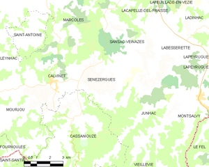
Sénezergues
- commune in Cantal, France
- Country:
- Postal Code: 15340
- Coordinates: 44° 42' 9" N, 2° 24' 47" E
- GPS tracks (wikiloc): [Link]
- Area: 17.61 sq km
- Population: 193


Marcolès
- commune in Cantal, France
- Country:
- Postal Code: 15220
- Coordinates: 44° 46' 55" N, 2° 21' 11" E
- GPS tracks (wikiloc): [Link]
- Area: 52.89 sq km
- Population: 587
- Web site: [Link]
Labesserette
- commune in Cantal, France
- Country:
- Postal Code: 15120
- Coordinates: 44° 44' 31" N, 2° 27' 40" E
- GPS tracks (wikiloc): [Link]
- Area: 13.64 sq km
- Population: 292
Lacapelle-del-Fraisse
- commune in Cantal, France
- Country:
- Postal Code: 15120
- Coordinates: 44° 46' 49" N, 2° 26' 12" E
- GPS tracks (wikiloc): [Link]
- AboveSeaLevel: 830 м m
- Area: 15.29 sq km
- Population: 334