Sant'Agata di Esaro (Sant'Agata di Esaro)
.svg)
- Italian comune
 Hiking in Sant'Agata di Esaro
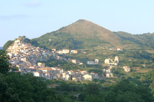
Hiking in Sant'Agata di Esaro, a charming village in Calabria, Italy, offers a delightful experience for outdoor enthusiasts. Nestled in the foothills of the Pollino National Park, this area is characterized by stunning landscapes, rich biodiversity, and a variety of trails suitable for different skill levels.
Key Features of Hiking in Sant'Agata di Esaro:
-
Natural Beauty: The region is known for its breathtaking views, including rolling hills, dense forests, and picturesque mountain scenery. Wildflowers and diverse fauna can also be observed, enhancing the hiking experience.
-
Pollino National Park: Being close to one of Italy's largest national parks, hikers have access to numerous trails that range from easy walks to more challenging treks. The park is also home to rare species and numerous streams and rivers.
-
Local Trails: There are several marked trails in and around Sant'Agata di Esaro. These trails can take you through olive groves, vineyards, and to various scenic lookout points that allow for panoramic views of the surrounding countryside.
-
Cultural Experiences: While hiking, you can also explore the local culture. Sant'Agata di Esaro and nearby towns are steeped in history, with opportunities to visit ancient churches, historical buildings, and sample local cuisine.
-
Seasonal Considerations: The best times for hiking are typically during late spring and early autumn when the weather is mild, and the landscapes are vibrant. Summer can be hot, while winter may bring snow to higher elevations.
-
Safety and Preparedness: As with any hiking adventure, it's essential to be prepared. Consider bringing adequate supplies (water, snacks, appropriate clothing, and a map), and always inform someone about your hiking plans.
-
Guided Tours: If you're unfamiliar with the area or trails, consider joining a guided hike. Local guides can provide valuable insights into the flora, fauna, and history, enhancing your overall experience.
Conclusion
Hiking in Sant'Agata di Esaro offers a perfect mix of adventure, natural beauty, and cultural richness. Whether you're a seasoned hiker or a casual walker, the trails around this charming village have something to offer everyone. Enjoy your hike!
- Country:

- Postal Code: 87010
- Local Dialing Code: 0981
- Licence Plate Code: CS
- Coordinates: 39° 37' 0" N, 15° 59' 0" E


- GPS tracks (wikiloc): [Link]
- AboveSeaLevel: 450 м m
- Area: 47.63 sq km
- Population: 1841
- Web site: http://www.comune.santagatadiesaro.cs.it/
- Wikipedia en: wiki(en)
- Wikipedia: wiki(it)
- Wikidata storage: Wikidata: Q53986
- Freebase ID: [/m/0f_n1n]
- GeoNames ID: Alt: [6539062]
- VIAF ID: Alt: [157397902]
- OSM relation ID: [39988]
- ISTAT ID: 078131
- Italian cadastre code: I192
Shares border with regions:


Belvedere Marittimo
- Italian comune
Hiking in Belvedere Marittimo
Belvedere Marittimo, located on the Tyrrhenian coast of Calabria in southern Italy, offers a unique combination of stunning coastal views and mountainous landscapes, making it a great destination for hiking enthusiasts. Here are some key aspects to consider when hiking in and around this picturesque town:...
- Country:
- Postal Code: 87021
- Local Dialing Code: 0985
- Licence Plate Code: CS
- Coordinates: 39° 37' 0" N, 15° 52' 0" E
- GPS tracks (wikiloc): [Link]
- AboveSeaLevel: 0 м m
- Area: 37.09 sq km
- Population: 9239
- Web site: [Link]

Bonifati
- Italian comune
Hiking in Bonifati
Bonifati, located along the Tyrrhenian coast in Calabria, Italy, offers a stunning setting for hiking enthusiasts. The area is characterized by beautiful coastal landscapes, rugged cliffs, and lush vegetation, making it an attractive destination for outdoor activities. Here are some highlights and tips for hiking in Bonifati:...
- Country:
- Postal Code: 87020
- Local Dialing Code: 0982
- Licence Plate Code: CS
- Coordinates: 39° 35' 0" N, 15° 54' 0" E
- GPS tracks (wikiloc): [Link]
- AboveSeaLevel: 425 м m
- Area: 33.85 sq km
- Population: 2788
- Web site: [Link]
Buonvicino
- Italian comune
Hiking in Buonvicino
Buonvicino is a charming small town located in the Calabria region of southern Italy, known for its beautiful landscapes, mountainous terrain, and proximity to the Pollino National Park. Hiking in and around Buonvicino offers a variety of trails that cater to different skill levels, making it an ideal spot for both novice and experienced hikers. Here are some highlights for hiking in this area:...
- Country:
- Postal Code: 87020
- Local Dialing Code: 0985
- Licence Plate Code: CS
- Coordinates: 39° 41' 0" N, 15° 53' 0" E
- GPS tracks (wikiloc): [Link]
- AboveSeaLevel: 400 м m
- Area: 30.6 sq km
- Population: 2229
- Web site: [Link]


Cetraro
- Italian comune
Hiking in Cetraro
Cetraro, a charming coastal town located in Calabria, Italy, offers some beautiful hiking opportunities for outdoor enthusiasts. The area is characterized by its stunning landscapes, including coastal views, forests, and hills....
- Country:
- Postal Code: 87022
- Local Dialing Code: 0982
- Licence Plate Code: CS
- Coordinates: 39° 30' 0" N, 15° 57' 0" E
- GPS tracks (wikiloc): [Link]
- AboveSeaLevel: 120 м m
- Area: 66.14 sq km
- Population: 10048
- Web site: [Link]


Malvito
- Italian comune
Hiking in Malvito
Malvito is a small village located in the Calabria region of Italy, known for its stunning landscapes and proximity to the Sila National Park. Hiking in this area offers a unique experience due to the beautiful natural surroundings, rich biodiversity, and the chance to explore traditional Calabrian culture....
- Country:
- Postal Code: 87010
- Local Dialing Code: 0984
- Licence Plate Code: CS
- Coordinates: 39° 36' 0" N, 16° 3' 0" E
- GPS tracks (wikiloc): [Link]
- AboveSeaLevel: 473 м m
- Area: 38.24 sq km
- Population: 1746
- Web site: [Link]
Mottafollone
- Italian comune
Hiking in Mottafollone
Mottafollone, located in the Calabria region of southern Italy, is a hidden gem for hiking enthusiasts. Nestled in the Sila National Park, this area offers stunning landscapes, diverse flora and fauna, and various hiking trails suitable for different skill levels. Here are some highlights for hiking in Mottafollone:...
- Country:
- Postal Code: 87010
- Local Dialing Code: 0981
- Licence Plate Code: CS
- Coordinates: 39° 39' 0" N, 16° 4' 0" E
- GPS tracks (wikiloc): [Link]
- AboveSeaLevel: 384 м m
- Area: 31.58 sq km
- Population: 1215
- Web site: [Link]
Sangineto
- Italian comune
Hiking in Sangineto
Sangineto, located in the Calabria region of Italy, offers a variety of hiking opportunities set against a stunning landscape characterized by beautiful coastline, mountains, and lush greenery. The area is known for its natural beauty and diverse ecosystems, making it a great destination for outdoor enthusiasts....
- Country:
- Postal Code: 87020
- Local Dialing Code: 0982
- Licence Plate Code: CS
- Coordinates: 39° 36' 15" N, 15° 54' 51" E
- GPS tracks (wikiloc): [Link]
- AboveSeaLevel: 275 м m
- Area: 27.51 sq km
- Population: 1297
- Web site: [Link]