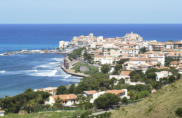
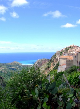
Buonvicino (Buonvicino)
.svg)
- Italian comune
 Hiking in Buonvicino
Buonvicino is a charming small town located in the Calabria region of southern Italy, known for its beautiful landscapes, mountainous terrain, and proximity to the Pollino National Park. Hiking in and around Buonvicino offers a variety of trails that cater to different skill levels, making it an ideal spot for both novice and experienced hikers. Here are some highlights for hiking in this area:
Trails and Routes
-
Pollino National Park: Just a short distance from Buonvicino, this park is one of the largest in Italy and features stunning trails with breathtaking views. You can explore various routes that take you through majestic forests, alpine meadows, and up to mountain peaks.
-
Mount Pollino: The highest peak in the southern Apennines, this area offers a challenging hike with spectacular panoramas. The trail leading to the summit can be demanding but is rewarding for those who complete it.
-
Riviera dei Cedri Trails: The coastal trails near Buonvicino provide a mix of mountain and sea views, with opportunities to enjoy the stunning coastline while hiking through lush Mediterranean vegetation.
Tips for Hiking in Buonvicino
-
Best Time to Hike: The ideal months for hiking are usually from April to June and from September to October when the weather is more moderate.
-
Gear: Ensure you wear proper hiking boots and bring appropriate clothing layers, as weather can change quickly in mountainous areas.
-
Mapping: It's advisable to have a map or a GPS device. While many trails are well-marked, it's easy to get turned around in more remote areas.
-
Local Guidance: Consider hiring a local guide, especially if you are unfamiliar with the terrain. Guides can provide insights into the local flora, fauna, and culture, enhancing your hiking experience.
-
Hydration and Snacks: Always carry enough water and snacks to keep your energy up, especially on longer hikes.
Cultural Aspects
While hiking, take time to enjoy the historic and cultural elements of Buonvicino itself, such as traditional architecture, local cuisine, and perhaps some interaction with the locals who are often open and friendly.
Remember to respect the environment by sticking to marked trails and following Leave No Trace principles to preserve the natural beauty of the area for future generations. Enjoy your hiking adventure in Buonvicino!
- Country:

- Postal Code: 87020
- Local Dialing Code: 0985
- Licence Plate Code: CS
- Coordinates: 39° 41' 0" N, 15° 53' 0" E


- GPS tracks (wikiloc): [Link]
- AboveSeaLevel: 400 м m
- Area: 30.6 sq km
- Population: 2229
- Web site: http://comune.buonvicino.cs.it
- Wikipedia en: wiki(en)
- Wikipedia: wiki(it)
- Wikidata storage: Wikidata: Q53845
- Wikipedia Commons Category: [Link]
- Freebase ID: [/m/0f_my4]
- GeoNames ID: Alt: [6537658]
- VIAF ID: Alt: [236122905]
- OSM relation ID: [40029]
- GND ID: Alt: [4643116-0]
- WOEID: [711534]
- UN/LOCODE: [ITBUV]
- ISTAT ID: 078020
- Italian cadastre code: B270
Shares border with regions:


Belvedere Marittimo
- Italian comune
Hiking in Belvedere Marittimo
Belvedere Marittimo, located on the Tyrrhenian coast of Calabria in southern Italy, offers a unique combination of stunning coastal views and mountainous landscapes, making it a great destination for hiking enthusiasts. Here are some key aspects to consider when hiking in and around this picturesque town:...
- Country:
- Postal Code: 87021
- Local Dialing Code: 0985
- Licence Plate Code: CS
- Coordinates: 39° 37' 0" N, 15° 52' 0" E
- GPS tracks (wikiloc): [Link]
- AboveSeaLevel: 0 м m
- Area: 37.09 sq km
- Population: 9239
- Web site: [Link]

Diamante
- Italian comune
Hiking in Diamante
Hiking in Diamante, Calabria, can be a truly rewarding experience. This charming coastal town, located on the Tyrrhenian Sea, is known for its stunning views, beautiful beaches, and the rugged landscape of the surrounding mountains. Here are some key points to consider when hiking in and around Diamante:...
- Country:
- Postal Code: 87023
- Local Dialing Code: 0985
- Licence Plate Code: CS
- Coordinates: 39° 41' 0" N, 15° 49' 0" E
- GPS tracks (wikiloc): [Link]
- AboveSeaLevel: 22 м m
- Area: 12.21 sq km
- Population: 5295
- Web site: [Link]

Grisolia
- Italian comune
Hiking in Grisolia
Grisolia is a beautiful location situated in the Calabria region of Italy, known for its stunning coastal views and mountainous terrain. Hiking in and around Grisolia offers a range of experiences suitable for various skill levels, with the opportunity to explore both nature and charming local culture....
- Country:
- Postal Code: 87020
- Local Dialing Code: 0985
- Licence Plate Code: CS
- Coordinates: 39° 43' 0" N, 15° 51' 0" E
- GPS tracks (wikiloc): [Link]
- AboveSeaLevel: 480 м m
- Area: 51.75 sq km
- Population: 2223
- Web site: [Link]


Maierà
- Italian comune
Hiking in Maierà
Maierà, a charming village in Calabria, Italy, offers a unique hiking experience, blending the beauty of nature with rich cultural history. Nestled in the heart of the Aspromonte National Park, this area is perfect for outdoor enthusiasts looking for picturesque trails and stunning landscapes....
- Country:
- Postal Code: 87020
- Local Dialing Code: 0985
- Licence Plate Code: CS
- Coordinates: 39° 43' 0" N, 15° 51' 0" E
- GPS tracks (wikiloc): [Link]
- AboveSeaLevel: 360 м m
- Area: 17.78 sq km
- Population: 1226
- Web site: [Link]
Mottafollone
- Italian comune
Hiking in Mottafollone
Mottafollone, located in the Calabria region of southern Italy, is a hidden gem for hiking enthusiasts. Nestled in the Sila National Park, this area offers stunning landscapes, diverse flora and fauna, and various hiking trails suitable for different skill levels. Here are some highlights for hiking in Mottafollone:...
- Country:
- Postal Code: 87010
- Local Dialing Code: 0981
- Licence Plate Code: CS
- Coordinates: 39° 39' 0" N, 16° 4' 0" E
- GPS tracks (wikiloc): [Link]
- AboveSeaLevel: 384 м m
- Area: 31.58 sq km
- Population: 1215
- Web site: [Link]
San Sosti
- Italian comune
Hiking in San Sosti
San Sosti is a charming village located in the Calabria region of southern Italy, nestled in the foothills of the Pollino National Park. This area is characterized by its stunning natural landscapes, rich biodiversity, and scenic hiking routes, making it a great destination for outdoor enthusiasts....
- Country:
- Postal Code: 87010
- Local Dialing Code: 0981
- Licence Plate Code: CS
- Coordinates: 39° 40' 0" N, 16° 2' 0" E
- GPS tracks (wikiloc): [Link]
- AboveSeaLevel: 355 м m
- Area: 43.55 sq km
- Population: 2169
- Web site: [Link]
Sant'Agata di Esaro
- Italian comune
Hiking in Sant'Agata di Esaro
Hiking in Sant'Agata di Esaro, a charming village in Calabria, Italy, offers a delightful experience for outdoor enthusiasts. Nestled in the foothills of the Pollino National Park, this area is characterized by stunning landscapes, rich biodiversity, and a variety of trails suitable for different skill levels....
- Country:
- Postal Code: 87010
- Local Dialing Code: 0981
- Licence Plate Code: CS
- Coordinates: 39° 37' 0" N, 15° 59' 0" E
- GPS tracks (wikiloc): [Link]
- AboveSeaLevel: 450 м m
- Area: 47.63 sq km
- Population: 1841
- Web site: [Link]