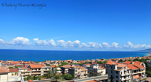
Sant'Agata di Militello (Sant'Agata di Militello)
.svg)
- Italian comune
 Hiking in Sant'Agata di Militello
Sant'Agata di Militello, located in the province of Messina in Sicily, is surrounded by beautiful natural landscapes that offer excellent hiking opportunities. The area is characterized by its scenic views, mountainous terrain, and proximity to the Nebrodi National Park, which is one of the largest protected natural areas in Sicily.
Hiking Opportunities
-
Nebrodi National Park:
- This park offers a variety of trails ranging from easy walks to more challenging hikes. The park is known for its rich biodiversity, including forests of beech and fir trees, as well as unique wildlife. Popular routes include trails leading to Mount Soro and Mount Etna.
-
Monte Capra:
- A hike to Monte Capra provides stunning panoramic views of the surrounding region, including the coast. The trail can be moderate to challenging, depending on the route you choose.
-
The NEBRODI Trail:
- This long-distance trail traverses the entire Nebrodi mountain range, offering sections that can be tackled over days or shorter segments for day hikes.
-
Local Trails:
- There are several lesser-known local trails around Sant'Agata di Militello that can lead you through picturesque villages and offer a glimpse of local culture. These paths often lead to historical sites and natural attractions.
Essentials for Hiking in the Area
-
Maps and Guides: It’s essential to have a good map or a hiking guide specific to the region, as well as a GPS device if possible.
-
Weather Considerations: Check weather conditions before heading out, as mountain weather can change rapidly.
-
Safety Gear: Always wear appropriate hiking gear, including sturdy boots, and carry a first aid kit, plenty of water, snacks, and sun protection.
-
Leave No Trace: Respect nature by sticking to trails, packing out what you bring in, and not disturbing wildlife.
Best Times to Hike:
The ideal times to hike in Sant'Agata di Militello are during the spring (April to June) and fall (September to October) when the weather is mild and the landscapes are vibrant. Summer can be quite hot, and winter trails may be impassable due to snow in higher elevations.
Local Culture and History:
As you explore the hiking trails, you might come across historical sites, ancient ruins, and charming Sicilian villages. Take the time to enjoy the local cuisine and hospitality which can enhance your hiking experience.
Overall, Sant'Agata di Militello offers a wonderful blend of natural beauty and cultural richness, making it a great destination for hiking enthusiasts.
- Country:

- Postal Code: 98076
- Local Dialing Code: 0941
- Licence Plate Code: ME
- Coordinates: 38° 4' 0" N, 14° 38' 0" E


- GPS tracks (wikiloc): [Link]
- AboveSeaLevel: 30 м m
- Area: 33.98 sq km
- Population: 12393
- Web site: http://www.comune.santagatadimilitello.me.it
- Wikipedia en: wiki(en)
- Wikipedia: wiki(it)
- Wikidata storage: Wikidata: Q491724
- Wikipedia Commons Category: [Link]
- Freebase ID: [/m/0gqf4c]
- GeoNames ID: Alt: [6537770]
- OSM relation ID: [39500]
- GND ID: Alt: [5332247-2]
- WOEID: [723268]
- UN/LOCODE: [ITSAG]
- ISTAT ID: 083084
- Italian cadastre code: I199
Shares border with regions:

Acquedolci
- Italian comune
Hiking in Acquedolci
Acquedolci, located in Sicily, Italy, offers a variety of hiking opportunities that showcase the region's natural beauty and rich cultural heritage. Here are some key aspects to consider if you're planning a hike in and around Acquedolci:...
- Country:
- Postal Code: 98070
- Local Dialing Code: 0941
- Licence Plate Code: ME
- Coordinates: 38° 3' 0" N, 14° 35' 0" E
- GPS tracks (wikiloc): [Link]
- AboveSeaLevel: 15 м m
- Area: 12.93 sq km
- Population: 5663
- Web site: [Link]


Militello Rosmarino
- Italian comune
Hiking in Militello Rosmarino
Militello Rosmarino, a charming town in Sicily, Italy, offers some wonderful opportunities for hiking, thanks to its scenic landscapes, mountainous terrain, and proximity to the Nebrodi National Park....
- Country:
- Postal Code: 98070
- Local Dialing Code: 0941
- Licence Plate Code: ME
- Coordinates: 38° 3' 0" N, 14° 41' 0" E
- GPS tracks (wikiloc): [Link]
- AboveSeaLevel: 450 м m
- Area: 29.54 sq km
- Population: 1276
- Web site: [Link]


San Fratello
- Italian comune
Hiking in San Fratello
San Fratello is a charming town in Sicily, Italy, nestled in the Nebrodi Mountains. The area is known for its stunning landscapes, diverse flora and fauna, and rich cultural heritage, making it a great destination for hiking enthusiasts....
- Country:
- Postal Code: 98075
- Local Dialing Code: 0941
- Licence Plate Code: ME
- Coordinates: 38° 0' 46" N, 14° 35' 51" E
- GPS tracks (wikiloc): [Link]
- AboveSeaLevel: 675 м m
- Area: 67.63 sq km
- Population: 3592
- Web site: [Link]
Torrenova
- Italian comune
Hiking in Torrenova
Torrenova, located on the island of Mallorca in Spain, offers beautiful scenic views and a variety of hiking opportunities. The region is known for its stunning coastal paths, mountainous terrains, and lush natural landscapes. Here are some key points to consider for hiking in Torrenova:...
- Country:
- Postal Code: 98070
- Local Dialing Code: 0941
- Licence Plate Code: ME
- Coordinates: 38° 5' 33" N, 14° 40' 45" E
- GPS tracks (wikiloc): [Link]
- AboveSeaLevel: 10 м m
- Area: 12.93 sq km
- Population: 4446
- Web site: [Link]


Caronia
- Italian comune
Hiking in Caronia
Caronia, a small coastal town in Sicily, Italy, is a great place for hiking enthusiasts who appreciate stunning landscapes and a rich cultural backdrop. While the town itself may not have extensive marked trails, the surrounding areas offer a variety of hiking opportunities....
- Country:
- Postal Code: 98072
- Local Dialing Code: 0921
- Licence Plate Code: ME
- Coordinates: 38° 1' 0" N, 14° 26' 0" E
- GPS tracks (wikiloc): [Link]
- AboveSeaLevel: 304 м m
- Area: 227.26 sq km
- Population: 3279
- Web site: [Link]