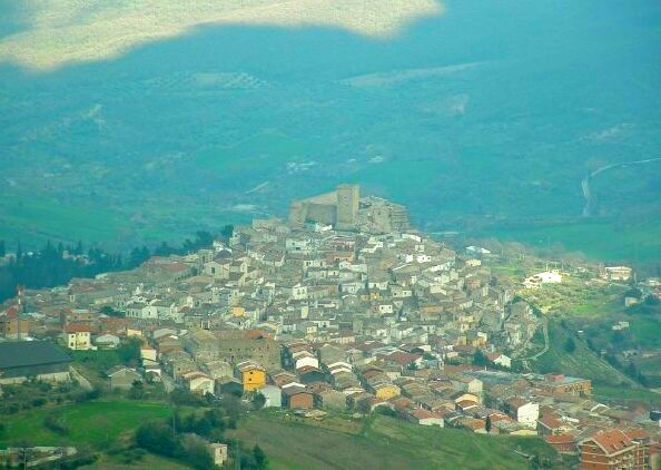
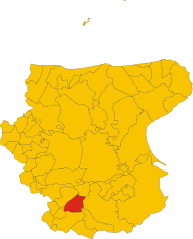
Sant'Agata di Puglia (Sant'Agata di Puglia)
.svg)
- Italian comune
 Hiking in Sant'Agata di Puglia
Sant'Agata di Puglia, located in the Apulia region of Italy, offers a beautiful setting for hiking enthusiasts. This charming town is surrounded by picturesque landscapes, rolling hills, and lush forests, making it an ideal destination for outdoor activities.
Hiking Trails
-
Monte Stilo: One of the most popular hiking locations near Sant'Agata di Puglia. The trail offers stunning panoramic views of the surrounding countryside and the opportunity to explore the natural flora and fauna.
-
Parco Nazionale del Gargano: A bit further afield, this national park has a variety of trails ranging from easy to challenging. It features a mix of mountainous terrain, coastal paths, and rich biodiversity.
-
Local Nature Trails: There are several marked trails around the town itself that lead through the hills and valleys. These trails often pass by ancient olive groves, vineyards, and offer glimpses into the local agricultural practices.
Tips for Hiking in Sant'Agata di Puglia
- Best Time to Hike: The ideal seasons for hiking in this region are spring (April to June) and early autumn (September to October) when the weather is mild and the landscapes are vibrant.
- Guided Tours: For those unfamiliar with the area, consider joining a guided hiking tour. Local guides can provide insights into the history, culture, and ecology of the region.
- Preparation: Ensure you have appropriate hiking gear, including sturdy shoes, water, and snacks. Some trails can be rugged, so good preparation is key.
What to Expect
- Scenic Views: Expect breathtaking views of the Apulian countryside, with its unique geographical features and diverse ecosystems.
- Wildlife: Keep an eye out for local wildlife, including various bird species and small mammals that inhabit the area.
Additional Attractions
While visiting Sant'Agata di Puglia, take time to explore the town itself, which boasts historical architecture and local cuisine. After a day of hiking, enjoy traditional Apulian dishes in local trattorias.
Overall, hiking in and around Sant'Agata di Puglia offers a perfect blend of adventure, nature, and cultural exploration.
- Country:

- Postal Code: 71028
- Local Dialing Code: 0881
- Licence Plate Code: FG
- Coordinates: 41° 9' 10" N, 15° 22' 51" E


- GPS tracks (wikiloc): [Link]
- AboveSeaLevel: 813 м m
- Area: 116.14 sq km
- Population: 1908
- Web site: http://www.comune.santagatadipuglia.fg.it/
- Wikipedia en: wiki(en)
- Wikipedia: wiki(it)
- Wikidata storage: Wikidata: Q51958
- Wikipedia Commons Category: [Link]
- Freebase ID: [/m/0fz6k0]
- GeoNames ID: Alt: [6539834]
- VIAF ID: Alt: [156001162]
- OSM relation ID: [41102]
- Library of Congress authority ID: Alt: [n85084439]
- MusicBrainz area ID: [ab68ee8c-792c-4b6b-82ac-c0f4240f67b4]
- ISTAT ID: 071052
- Italian cadastre code: I193
Shares border with regions:


Accadia
- Italian comune
Hiking in Accadia
Acadia National Park, located on Mount Desert Island off the coast of Maine, is a stunning destination for hikers and outdoor enthusiasts. Here are some key details about hiking in Acadia:...
- Country:
- Postal Code: 71021
- Local Dialing Code: 0881
- Licence Plate Code: FG
- Coordinates: 41° 10' 0" N, 15° 20' 0" E
- GPS tracks (wikiloc): [Link]
- AboveSeaLevel: 650 м m
- Area: 30.74 sq km
- Population: 2338
- Web site: [Link]
Anzano di Puglia
- Italian comune
Hiking in Anzano di Puglia
Anzano di Puglia is a charming town located in the Apulia region of Italy, surrounded by natural beauty and offer hiking opportunities. The area is characterized by its lush landscapes, rolling hills, and scenic views, making it a great destination for outdoor enthusiasts....
- Country:
- Postal Code: 71020
- Local Dialing Code: 0881
- Licence Plate Code: FG
- Coordinates: 41° 7' 0" N, 15° 17' 0" E
- GPS tracks (wikiloc): [Link]
- AboveSeaLevel: 760 м m
- Area: 11.02 sq km
- Population: 1225
- Web site: [Link]
Candela
- Italian comune
Hiking in Candela
Candela, located in the Apulia region of Italy, is a charming town situated within the province of Foggia. It sits at an elevation of about 400 meters above sea level, surrounded by the rolling hills and picturesque landscapes typical of the area. Hiking here can be a unique experience, thanks to the combination of natural beauty, historical landmarks, and local culture....
- Country:
- Postal Code: 71024
- Local Dialing Code: 0885
- Licence Plate Code: FG
- Coordinates: 41° 8' 0" N, 15° 31' 0" E
- GPS tracks (wikiloc): [Link]
- AboveSeaLevel: 474 м m
- Area: 96.82 sq km
- Population: 2784
- Web site: [Link]
Deliceto
- Italian comune
Hiking in Deliceto
Deliceto is a charming small town located in the Apulia region of southern Italy, known for its beautiful landscapes, historical architecture, and natural surroundings. While it may not be as widely recognized for hiking as some other destinations, it offers several opportunities for outdoor enthusiasts to explore its scenic countryside and nearby areas....
- Country:
- Postal Code: 71026
- Local Dialing Code: 0881
- Licence Plate Code: FG
- Coordinates: 41° 13' 0" N, 15° 23' 0" E
- GPS tracks (wikiloc): [Link]
- AboveSeaLevel: 575 м m
- Area: 75.85 sq km
- Population: 3725
- Web site: [Link]


Monteleone di Puglia
- Italian comune
Hiking in Monteleone di Puglia
Monteleone di Puglia, located in the Apulia region of southern Italy, offers a unique blend of natural beauty and cultural heritage that makes it an attractive destination for hiking enthusiasts. The area is characterized by rolling hills, lush landscapes, and stunning views, which provide a fantastic backdrop for outdoor activities....
- Country:
- Postal Code: 71020
- Local Dialing Code: 0881
- Licence Plate Code: FG
- Coordinates: 41° 10' 0" N, 15° 16' 0" E
- GPS tracks (wikiloc): [Link]
- AboveSeaLevel: 859 м m
- Area: 36.42 sq km
- Population: 1019
- Web site: [Link]
Rocchetta Sant'Antonio
- Italian comune
Hiking in Rocchetta Sant'Antonio
Rocchetta Sant'Antonio is a picturesque village located in the Apulia region of southern Italy, nestled in the heart of the Daunian Mountains. It offers a range of hiking opportunities, showcasing stunning natural landscapes, historical sites, and local flora and fauna....
- Country:
- Postal Code: 71020
- Local Dialing Code: 0885
- Licence Plate Code: FG
- Coordinates: 41° 6' 0" N, 15° 28' 0" E
- GPS tracks (wikiloc): [Link]
- AboveSeaLevel: 630 м m
- Area: 72.48 sq km
- Population: 1820
- Web site: [Link]
Lacedonia
- Italian comune
Hiking in Lacedonia
Lacedonia, a town in the Campania region of Italy, offers some stunning landscapes and opportunities for hiking enthusiasts. Nestled in the hills and surrounded by natural beauty, hikers can enjoy a variety of trails that cater to different skill levels....
- Country:
- Postal Code: 83046
- Local Dialing Code: 0827
- Licence Plate Code: AV
- Coordinates: 41° 3' 8" N, 15° 25' 29" E
- GPS tracks (wikiloc): [Link]
- AboveSeaLevel: 732 м m
- Area: 82.1 sq km
- Population: 2275
- Web site: [Link]

Scampitella
- comune of Italy
Hiking in Scampitella
Scampitella is a picturesque town located in the Campania region of southern Italy, surrounded by beautiful landscapes that make it an appealing destination for hikers. Here are some highlights and considerations for hiking in and around Scampitella:...
- Country:
- Postal Code: 83050
- Local Dialing Code: 0827
- Licence Plate Code: AV
- Coordinates: 41° 6' 0" N, 15° 17' 0" E
- GPS tracks (wikiloc): [Link]
- AboveSeaLevel: 720 м m
- Area: 15.11 sq km
- Population: 1190
- Web site: [Link]