
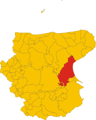
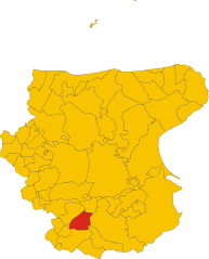
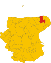
Province of Foggia (provincia di Foggia)

- province of Italy
 Hiking in Province of Foggia
The Province of Foggia, located in the Apulia region of Italy, is known for its diverse landscapes that offer unique hiking opportunities. Here are some highlights for hiking in this area:
1.
- Terrain: This park features a mix of forests, cliffs, and coastline. It is known for its stunning natural beauty and biodiversity.
- Trails: There are numerous trails that cater to various skill levels. Popular hikes include the paths leading to the Umbra Forest and the coastal routes that offer breathtaking views of the Adriatic Sea.
- Wildlife: Keep an eye out for local wildlife, including various birds, deer, and rare plant species.
2.
- Location: Within Gargano National Park, the Umbra Forest is a UNESCO Biosphere Reserve.
- Features: The forest is dense with beech trees, and it's cooler compared to the surrounding areas, making it an ideal spot for hiking, especially in the summer months.
- Trails: Several marked trails weave through the forest, providing options for both short and long hikes.
3.
- Accessibility: These islands can be reached by ferry from the mainland and offer a different hiking experience with their rugged coastlines and pristine beaches.
- Trails: Walking paths connect various viewpoints and beaches, providing spectacular views of the sea.
4.
- Height: The highest peak in the Apennines of the Apulia region at around 1,155 meters (3,789 feet).
- Hiking: Offers challenging trails with panoramic views. The ascent provides a rewarding experience, especially for seasoned hikers looking for a rewarding climb.
5.
- After a day of hiking, be sure to enjoy local cuisine, which features fresh seafood and traditional Apulian dishes like orecchiette pasta.
- There are also charming towns such as Vieste, Peschici, and Monte Sant'Angelo that are worth exploring for their historical significance and local culture.
Tips for Hiking in Foggia:
- Best Time to Go: Spring (April to June) and autumn (September to October) are ideal for hiking due to mild temperatures.
- Preparation: Carry plenty of water, snacks, and a map or GPS device, as some trails may not be well-marked.
- Weather: Check the local weather conditions before heading out, especially in the mountains.
- Respect Nature: Stick to marked trails and remember to follow Leave No Trace principles.
Overall, the Province of Foggia offers a rich combination of natural beauty and cultural experiences, making it an excellent destination for hiking enthusiasts.
- Country:

- Capital: Foggia
- Postal Code: 71121-71122, 71010-71049
- Licence Plate Code: FG
- Coordinates: 41° 28' 0" N, 15° 34' 0" E


- GPS tracks (wikiloc): [Link]
- Area: 6965 sq km
- Web site: http://www.laprovinciadifoggia.it
- Wikipedia en: wiki(en)
- Wikipedia: wiki(it)
- Wikidata storage: Wikidata: Q15129
- Wikipedia Commons Gallery: [Link]
- Wikipedia Commons Category: [Link]
- Freebase ID: [/m/053105]
- GeoNames ID: Alt: [3176884]
- GND ID: Alt: [4374309-2]
- archINFORM location ID: [2411]
- MusicBrainz area ID: [cde96964-8ceb-439f-9e53-177f0ac00fc5]
- DMOZ ID: Alt: [Regional/Europe/Italy/Regions/Puglia/Provinces/Foggia/]
- NUTS code: [ITF46]
- ISTAT ID: 071
- ISO 3166-2 code: IT-FG
Includes regions:


Foggia
- Italian comune
Hiking in Foggia
Foggia, located in the Apulia region of southeastern Italy, offers a diverse range of hiking opportunities that cater to various skill levels and preferences. The surrounding areas are known for their rich natural beauty, historical significance, and unique landscapes....
- Country:
- Postal Code: 71121–71122
- Local Dialing Code: 0881
- Licence Plate Code: FG
- Coordinates: 41° 28' 0" N, 15° 34' 0" E
- GPS tracks (wikiloc): [Link]
- AboveSeaLevel: 76 м m
- Area: 509.26 sq km
- Population: 151975
- Web site: [Link]
Pietramontecorvino
- Italian comune
Hiking in Pietramontecorvino
Pietramontecorvino is a charming hilltop village located in the province of Foggia, in the Apulia region of southern Italy. Surrounded by beautiful landscapes, it offers excellent hiking opportunities for nature enthusiasts....
- Country:
- Postal Code: 71038
- Local Dialing Code: 0881
- Licence Plate Code: FG
- Coordinates: 41° 33' 0" N, 15° 8' 0" E
- GPS tracks (wikiloc): [Link]
- AboveSeaLevel: 456 м m
- Area: 71.65 sq km
- Population: 2671
- Web site: [Link]


San Severo
- Italian comune
Hiking in San Severo
San Severo, located in the Apulia region of Italy, is known for its rich history, picturesque landscapes, and agricultural fields. While it may not be as famous as other Italian hiking destinations, it offers some charming opportunities for outdoor enthusiasts. Here are some aspects to consider for hiking in this area:...
- Country:
- Postal Code: 71016
- Local Dialing Code: 0882
- Licence Plate Code: FG
- Coordinates: 41° 41' 42" N, 15° 22' 45" E
- GPS tracks (wikiloc): [Link]
- AboveSeaLevel: 90 м m
- Area: 333 sq km
- Population: 53015
- Web site: [Link]


Cerignola
- Italian comune
Hiking in Cerignola
Cerignola, located in the Apulia region of southern Italy, is not as widely known for hiking as some of its other Italian counterparts, but it offers beautiful landscapes and opportunities for walking and exploring nature....
- Country:
- Postal Code: 71042; 71040
- Local Dialing Code: 0885
- Licence Plate Code: FG
- Coordinates: 41° 16' 0" N, 15° 54' 0" E
- GPS tracks (wikiloc): [Link]
- AboveSeaLevel: 120 м m
- Area: 593.93 sq km
- Population: 58540
- Web site: [Link]

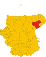
Manfredonia
- Italian comune
Hiking in Manfredonia
Manfredonia, located on the Adriatic coast of Italy in the Apulia region, offers a unique blend of natural beauty, cultural heritage, and hiking opportunities. The area is characterized by its stunning coastline, historical sites, and proximity to the Gargano National Park, which is a haven for outdoor enthusiasts....
- Country:
- Postal Code: 71043
- Local Dialing Code: 0884
- Licence Plate Code: FG
- Coordinates: 41° 38' 0" N, 15° 55' 0" E
- GPS tracks (wikiloc): [Link]
- AboveSeaLevel: 5 м m
- Area: 354.54 sq km
- Population: 56906
- Web site: [Link]


Accadia
- Italian comune
Hiking in Accadia
Acadia National Park, located on Mount Desert Island off the coast of Maine, is a stunning destination for hikers and outdoor enthusiasts. Here are some key details about hiking in Acadia:...
- Country:
- Postal Code: 71021
- Local Dialing Code: 0881
- Licence Plate Code: FG
- Coordinates: 41° 10' 0" N, 15° 20' 0" E
- GPS tracks (wikiloc): [Link]
- AboveSeaLevel: 650 м m
- Area: 30.74 sq km
- Population: 2338
- Web site: [Link]
Alberona
- Italian comune
Hiking in Alberona
Alberona is a charming village located in the Apennine mountains of Italy, specifically in the region of Puglia. While it's less known compared to some major hiking destinations, the surrounding areas offer several beautiful trails and natural scenery, making it an appealing location for hiking enthusiasts. Here are some key points about hiking around Alberona:...
- Country:
- Postal Code: 71031
- Local Dialing Code: 0881
- Licence Plate Code: FG
- Coordinates: 41° 26' 0" N, 15° 7' 0" E
- GPS tracks (wikiloc): [Link]
- AboveSeaLevel: 732 м m
- Area: 49.75 sq km
- Population: 956
- Web site: [Link]
Anzano di Puglia
- Italian comune
Hiking in Anzano di Puglia
Anzano di Puglia is a charming town located in the Apulia region of Italy, surrounded by natural beauty and offer hiking opportunities. The area is characterized by its lush landscapes, rolling hills, and scenic views, making it a great destination for outdoor enthusiasts....
- Country:
- Postal Code: 71020
- Local Dialing Code: 0881
- Licence Plate Code: FG
- Coordinates: 41° 7' 0" N, 15° 17' 0" E
- GPS tracks (wikiloc): [Link]
- AboveSeaLevel: 760 м m
- Area: 11.02 sq km
- Population: 1225
- Web site: [Link]


Apricena
- Italian comune
Hiking in Apricena
Apricena is a charming town located in the Apulia region of Italy, near the Adriatic coast and known for its beautiful limestone cliffs, olive groves, and scenic landscapes. Hiking in this region can offer a mix of coastal views, nature, and cultural experiences....
- Country:
- Postal Code: 71011
- Local Dialing Code: 0882
- Licence Plate Code: FG
- Coordinates: 41° 47' 5" N, 15° 26' 37" E
- GPS tracks (wikiloc): [Link]
- AboveSeaLevel: 73 м m
- Area: 172.51 sq km
- Population: 13174
- Web site: [Link]

Ascoli Satriano
- Italian comune
Hiking in Ascoli Satriano
Ascoli Satriano, located in the Puglia region of Italy, offers a variety of hiking opportunities amidst stunning landscapes and rich cultural heritage. Here are some key points about hiking in the area:...
- Country:
- Postal Code: 71022
- Local Dialing Code: 0885
- Licence Plate Code: FG
- Coordinates: 41° 12' 56" N, 15° 33' 28" E
- GPS tracks (wikiloc): [Link]
- AboveSeaLevel: 376 м m
- Area: 336.68 sq km
- Population: 6167
- Web site: [Link]


Biccari
- Italian comune
Hiking in Biccari
Biccari is a charming village located in the Apennine region of Italy, within the province of Foggia in Puglia. The area is known for its picturesque landscapes, rolling hills, and rich natural beauty, making it a great destination for hiking enthusiasts....
- Country:
- Postal Code: 71032
- Local Dialing Code: 0881
- Licence Plate Code: FG
- Coordinates: 41° 24' 0" N, 15° 12' 0" E
- GPS tracks (wikiloc): [Link]
- AboveSeaLevel: 450 м m
- Area: 106.65 sq km
- Population: 2760
- Web site: [Link]


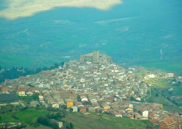
Bovino
- Italian comune
Hiking in Bovino
Bovino, a picturesque town in the Apennine Mountains of Italy, is known for its rich history, stunning landscapes, and hiking opportunities that cater to various skill levels. Here’s what you should know about hiking in and around Bovino:...
- Country:
- Postal Code: 71023
- Local Dialing Code: 0881
- Licence Plate Code: FG
- Coordinates: 41° 15' 0" N, 15° 21' 0" E
- GPS tracks (wikiloc): [Link]
- AboveSeaLevel: 647 м m
- Area: 84.93 sq km
- Population: 3256
- Web site: [Link]


Cagnano Varano
- Italian comune
Hiking in Cagnano Varano
Cagnano Varano is a picturesque town located in the province of Foggia, in the Apulia region of Italy. Nestled near the Gargano National Park, this area offers excellent opportunities for hiking enthusiasts, with stunning landscapes that include coastal views, forests, and the unique karst formations typical of the region....
- Country:
- Postal Code: 71010
- Local Dialing Code: 0884
- Licence Plate Code: FG
- Coordinates: 41° 50' 0" N, 15° 46' 0" E
- GPS tracks (wikiloc): [Link]
- AboveSeaLevel: 175 м m
- Area: 166.84 sq km
- Population: 7194
- Web site: [Link]
Candela
- Italian comune
Hiking in Candela
Candela, located in the Apulia region of Italy, is a charming town situated within the province of Foggia. It sits at an elevation of about 400 meters above sea level, surrounded by the rolling hills and picturesque landscapes typical of the area. Hiking here can be a unique experience, thanks to the combination of natural beauty, historical landmarks, and local culture....
- Country:
- Postal Code: 71024
- Local Dialing Code: 0885
- Licence Plate Code: FG
- Coordinates: 41° 8' 0" N, 15° 31' 0" E
- GPS tracks (wikiloc): [Link]
- AboveSeaLevel: 474 м m
- Area: 96.82 sq km
- Population: 2784
- Web site: [Link]
Carapelle
- Italian comune
Hiking in Carapelle
Carapelle, a charming town in the Apulia region of Italy, offers a variety of hiking opportunities, particularly due to its proximity to the beautiful landscapes of the Gargano National Park and the coastal trails along the Adriatic Sea....
- Country:
- Postal Code: 71041
- Local Dialing Code: 0885
- Licence Plate Code: FG
- Coordinates: 41° 22' 0" N, 15° 42' 0" E
- GPS tracks (wikiloc): [Link]
- AboveSeaLevel: 62 м m
- Area: 25 sq km
- Population: 6692
- Web site: [Link]


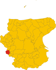
Carlantino
- Italian comune
Hiking in Carlantino
Carlantino is a charming town located in the province of Foggia, in the Apennine region of Italy. Though not as widely known as some other hiking destinations, it offers scenic landscapes and a taste of authentic Italian countryside, making it an appealing destination for those who enjoy outdoor activities....
- Country:
- Postal Code: 71030
- Local Dialing Code: 0881
- Licence Plate Code: FG
- Coordinates: 41° 35' 41" N, 14° 58' 31" E
- GPS tracks (wikiloc): [Link]
- AboveSeaLevel: 558 м m
- Area: 34.71 sq km
- Population: 957
- Web site: [Link]

Carpino
- Italian comune
Hiking in Carpino
Carpino, a charming town located in the Apulia region of Italy, offers a variety of hiking opportunities that cater to outdoor enthusiasts. The surrounding landscape features beautiful Mediterranean flora, rolling hills, and scenic views of the Adriatic Sea, making it an ideal location for hikers....
- Country:
- Postal Code: 71010
- Local Dialing Code: 0884
- Licence Plate Code: FG
- Coordinates: 41° 45' 0" N, 15° 50' 30" E
- GPS tracks (wikiloc): [Link]
- AboveSeaLevel: 147 м m
- Area: 80.05 sq km
- Population: 4101
- Web site: [Link]
Casalnuovo Monterotaro
- Italian comune
Hiking in Casalnuovo Monterotaro
Casalnuovo Monterotaro is a charming village located in the province of Foggia, in the Apulia region of Italy. While it may not be as widely known as some of the more famous hiking destinations, it offers a great opportunity for outdoor enthusiasts to explore beautiful natural landscapes and enjoy the serene atmosphere of the Italian countryside....
- Country:
- Postal Code: 71033
- Local Dialing Code: 0881
- Licence Plate Code: FG
- Coordinates: 41° 37' 0" N, 15° 6' 0" E
- GPS tracks (wikiloc): [Link]
- AboveSeaLevel: 432 м m
- Area: 48.36 sq km
- Population: 1507
- Web site: [Link]


Casalvecchio di Puglia
- Italian comune
Hiking in Casalvecchio di Puglia
Casalvecchio di Puglia is a charming village located in the Apulia region of southern Italy, nestled in the northern part of the province of Foggia. While it's not as widely recognized for hiking as some other areas in Italy, the surrounding landscape offers beautiful opportunities for outdoor activities....
- Country:
- Postal Code: 71030
- Local Dialing Code: 0881
- Licence Plate Code: FG
- Coordinates: 41° 36' 0" N, 15° 7' 0" E
- GPS tracks (wikiloc): [Link]
- AboveSeaLevel: 465 м m
- Area: 31.93 sq km
- Population: 1838
- Web site: [Link]
Castelluccio dei Sauri
- Italian comune
Hiking in Castelluccio dei Sauri
Castelluccio dei Sauri, a charming village located in the Apennine Mountains of Italy, is an excellent destination for hiking enthusiasts. Nestled in the province of Foggia, in the region of Puglia, this area is characterized by its stunning landscapes, varied terrain, and rich biodiversity....
- Country:
- Postal Code: 71025
- Local Dialing Code: 0881
- Licence Plate Code: FG
- Coordinates: 41° 18' 0" N, 15° 29' 0" E
- GPS tracks (wikiloc): [Link]
- AboveSeaLevel: 284 м m
- Area: 51.47 sq km
- Population: 2102
- Web site: [Link]
Castelluccio Valmaggiore
- Italian comune
Hiking in Castelluccio Valmaggiore
Castelluccio Valmaggiore is a charming village located in the province of Foggia in the Apulia region of Italy. It is set amidst the beautiful landscape of the Gargano National Park, which offers a variety of hiking opportunities for both beginners and experienced hikers....
- Country:
- Postal Code: 71020
- Local Dialing Code: 0881
- Licence Plate Code: FG
- Coordinates: 41° 21' 0" N, 15° 12' 0" E
- GPS tracks (wikiloc): [Link]
- AboveSeaLevel: 630 м m
- Area: 26.79 sq km
- Population: 1276
- Web site: [Link]
Castelnuovo della Daunia
- Italian comune
Hiking in Castelnuovo della Daunia
Castelnuovo della Daunia is a charming town located in the Apennine Mountains of Italy, specifically in the region of Apulia (Puglia). It offers a mix of historical sites and natural beauty, making it an attractive destination for hiking enthusiasts. Here’s what you can expect when hiking in and around Castelnuovo della Daunia:...
- Country:
- Postal Code: 71034
- Local Dialing Code: 0881
- Licence Plate Code: FG
- Coordinates: 41° 35' 0" N, 15° 7' 0" E
- GPS tracks (wikiloc): [Link]
- AboveSeaLevel: 600 м m
- Area: 61.49 sq km
- Population: 1390
- Web site: [Link]
Celenza Valfortore
- Italian comune
Hiking in Celenza Valfortore
Celenza Valfortore, a charming village located in the Province of Foggia in the Apulia region of Italy, is nestled in the picturesque landscape of the Apennine Mountains. The area offers diverse hiking opportunities, suitable for various skill levels, from beginners to experienced hikers....
- Country:
- Postal Code: 71035
- Local Dialing Code: 0881
- Licence Plate Code: FG
- Coordinates: 41° 34' 0" N, 14° 59' 0" E
- GPS tracks (wikiloc): [Link]
- AboveSeaLevel: 480 м m
- Area: 65.42 sq km
- Population: 1530
- Web site: [Link]


Celle di San Vito
- Italian comune
Hiking in Celle di San Vito
Celle di San Vito is a charming village located in the Apennine region of Italy, known for its stunning landscapes and rich natural beauty, making it a great destination for hiking enthusiasts. Here are some highlights and considerations for hiking in and around Celle di San Vito:...
- Country:
- Postal Code: 71020
- Local Dialing Code: 0881
- Licence Plate Code: FG
- Coordinates: 41° 20' 0" N, 15° 11' 0" E
- GPS tracks (wikiloc): [Link]
- AboveSeaLevel: 726 м m
- Area: 18.41 sq km
- Population: 160
- Web site: [Link]
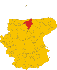
Chieuti
- Italian comune
Hiking in Chieuti
Chieuti, a small town in the Apulia region of Italy, offers a unique hiking experience, especially for those who enjoy exploring rural landscapes and coastal areas. While Chieuti itself is not widely known as a hiking hotspot, it is situated near the northern part of the Gargano National Park and the stunning Adriatic coastline, which provides numerous opportunities for outdoor enthusiasts....
- Country:
- Postal Code: 71010
- Local Dialing Code: 0882
- Licence Plate Code: FG
- Coordinates: 41° 51' 0" N, 15° 9' 0" E
- GPS tracks (wikiloc): [Link]
- AboveSeaLevel: 221 м m
- Area: 61.52 sq km
- Population: 1675
- Web site: [Link]
Deliceto
- Italian comune
Hiking in Deliceto
Deliceto is a charming small town located in the Apulia region of southern Italy, known for its beautiful landscapes, historical architecture, and natural surroundings. While it may not be as widely recognized for hiking as some other destinations, it offers several opportunities for outdoor enthusiasts to explore its scenic countryside and nearby areas....
- Country:
- Postal Code: 71026
- Local Dialing Code: 0881
- Licence Plate Code: FG
- Coordinates: 41° 13' 0" N, 15° 23' 0" E
- GPS tracks (wikiloc): [Link]
- AboveSeaLevel: 575 м m
- Area: 75.85 sq km
- Population: 3725
- Web site: [Link]


Faeto
- Italian comune
Hiking in Faeto
Faeto is a small village located in the Apulia region of southern Italy, nestled in the hills of the Daunia mountains. This picturesque area offers a variety of hiking opportunities characterized by beautiful landscapes, rich natural diversity, and a somewhat mild climate....
- Country:
- Postal Code: 71020
- Local Dialing Code: 0881
- Licence Plate Code: FG
- Coordinates: 41° 19' 30" N, 15° 9' 39" E
- GPS tracks (wikiloc): [Link]
- AboveSeaLevel: 820 м m
- Area: 26.1 sq km
- Population: 628
- Web site: [Link]

Ischitella
- Italian comune
Hiking in Ischitella
Ischitella is a charming town located in the Apulia region of Italy, known for its stunning landscapes, historical sites, and proximity to beautiful coastal areas. Though it may not be as widely recognized as some other hiking destinations, it offers several opportunities for outdoor enthusiasts and nature lovers. Here are a few details to consider when hiking in and around Ischitella:...
- Country:
- Postal Code: 71010
- Local Dialing Code: 0884
- Licence Plate Code: FG
- Coordinates: 41° 54' 16" N, 15° 53' 58" E
- GPS tracks (wikiloc): [Link]
- AboveSeaLevel: 310 м m
- Area: 85.46 sq km
- Population: 4411
- Web site: [Link]

Isole Tremiti
- Italian comune
Hiking in Isole Tremiti
Isole Tremiti, an archipelago located in the Adriatic Sea off the coast of Italy, is known for its stunning natural beauty, crystal-clear waters, and charming landscapes, making it a great hiking destination. The archipelago consists of five main islands: San Domino, San Nicola, Capraia, Pianosa, and Cretaccio, with San Domino being the largest and most developed....
- Country:
- Postal Code: 71040
- Local Dialing Code: 0882
- Licence Plate Code: FG
- Coordinates: 42° 7' 0" N, 15° 30' 0" E
- GPS tracks (wikiloc): [Link]
- AboveSeaLevel: 70 м m
- Area: 3.18 sq km
- Population: 490
- Web site: [Link]
Lesina
- Italian comune
Hiking in Lesina
Lesina, located in the Apulia region of Italy, is known for its scenic landscapes, charming coastal areas, and rich natural resources, making it an excellent destination for hiking enthusiasts. Here are some key points about hiking in and around Lesina:...
- Country:
- Postal Code: 71010
- Local Dialing Code: 0882
- Licence Plate Code: FG
- Coordinates: 41° 52' 0" N, 15° 21' 0" E
- GPS tracks (wikiloc): [Link]
- AboveSeaLevel: 5 м m
- Area: 160.16 sq km
- Population: 6347
- Web site: [Link]

Lucera
- Italian comune
Hiking in Lucera
Lucera, located in the Apulia region of southern Italy, offers a variety of hiking opportunities that allow you to experience the beautiful landscapes, historical sites, and unique flora and fauna of the area. Here are some key points to consider for hiking in and around Lucera:...
- Country:
- Postal Code: 71036
- Local Dialing Code: 0881
- Licence Plate Code: FG
- Coordinates: 41° 30' 0" N, 15° 20' 0" E
- GPS tracks (wikiloc): [Link]
- AboveSeaLevel: 50 м m
- Area: 339.79 sq km
- Population: 33085
- Web site: [Link]

Mattinata
- Italian comune
Hiking in Mattinata
Mattinata, located in the Apulia region of Italy along the Gargano National Park, offers stunning hiking opportunities with breathtaking views of the Adriatic Sea, dramatic cliffs, and lush Mediterranean vegetation. Here are some key highlights and tips for hiking in the area:...
- Country:
- Postal Code: 71030
- Local Dialing Code: 0884
- Licence Plate Code: FG
- Coordinates: 41° 43' 0" N, 16° 3' 0" E
- GPS tracks (wikiloc): [Link]
- AboveSeaLevel: 80 м m
- Area: 73.48 sq km
- Population: 6261
- Web site: [Link]

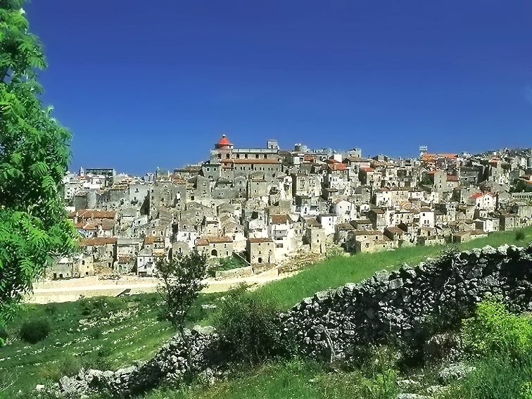
Monte Sant'Angelo
- Italian comune
Hiking in Monte Sant'Angelo
Monte Sant'Angelo is a scenic town located in the Apulia region of southern Italy, situated on the Gargano Peninsula. It offers a variety of hiking opportunities, characterized by stunning landscapes, rich historical sites, and diverse flora and fauna....
- Country:
- Postal Code: 71037
- Local Dialing Code: 0884
- Licence Plate Code: FG
- Coordinates: 41° 42' 0" N, 15° 58' 0" E
- GPS tracks (wikiloc): [Link]
- AboveSeaLevel: 796 м m
- Area: 245.13 sq km
- Population: 12342
- Web site: [Link]


Monteleone di Puglia
- Italian comune
Hiking in Monteleone di Puglia
Monteleone di Puglia, located in the Apulia region of southern Italy, offers a unique blend of natural beauty and cultural heritage that makes it an attractive destination for hiking enthusiasts. The area is characterized by rolling hills, lush landscapes, and stunning views, which provide a fantastic backdrop for outdoor activities....
- Country:
- Postal Code: 71020
- Local Dialing Code: 0881
- Licence Plate Code: FG
- Coordinates: 41° 10' 0" N, 15° 16' 0" E
- GPS tracks (wikiloc): [Link]
- AboveSeaLevel: 859 м m
- Area: 36.42 sq km
- Population: 1019
- Web site: [Link]
Motta Montecorvino
- Italian comune
Hiking in Motta Montecorvino
Motta Montecorvino is a beautiful area in the province of Foggia, located in the Apennine Mountains of southern Italy. This region is known for its scenic landscapes, rich flora and fauna, and historical significance. Hiking in Motta Montecorvino can be a rewarding experience for both beginner and experienced hikers....
- Country:
- Postal Code: 71030
- Local Dialing Code: 0881
- Licence Plate Code: FG
- Coordinates: 41° 30' 0" N, 15° 7' 0" E
- GPS tracks (wikiloc): [Link]
- AboveSeaLevel: 662 м m
- Area: 19.94 sq km
- Population: 712
- Web site: [Link]


Ordona
- Italian comune
Hiking in Ordona
Ordona is a small town in the province of Foggia, Italy, and while it may not be as widely recognized for hiking as some other destinations, there are still opportunities for outdoor enthusiasts in the surrounding areas....
- Country:
- Postal Code: 71040
- Local Dialing Code: 0885
- Licence Plate Code: FG
- Coordinates: 41° 19' 0" N, 15° 38' 0" E
- GPS tracks (wikiloc): [Link]
- AboveSeaLevel: 120 м m
- Area: 39.57 sq km
- Population: 2843
- Web site: [Link]
Orsara di Puglia
- Italian comune
Hiking in Orsara di Puglia
Orsara di Puglia is a picturesque village located in the province of Foggia in the Apulia region of Italy. Surrounded by the lush landscapes of the Gargano National Park and the rolling hills of the Daunian Mountains, it offers a variety of hiking opportunities for nature enthusiasts and adventure seekers....
- Country:
- Postal Code: 71027
- Local Dialing Code: 0881
- Licence Plate Code: FG
- Coordinates: 41° 17' 0" N, 15° 16' 0" E
- GPS tracks (wikiloc): [Link]
- AboveSeaLevel: 635 м m
- Area: 83.01 sq km
- Population: 2704
- Web site: [Link]
Orta Nova
- Italian comune
Hiking in Orta Nova
Orta Nova is a charming town located in the Apulia region of southern Italy, not far from the beautiful landscapes of the Gargano National Park and the Tavoliere delle Puglie. While the town and its immediate area might not be well-known as a hiking destination, there are still opportunities for nature walks and exploring the countryside....
- Country:
- Postal Code: 71045
- Local Dialing Code: 0885
- Licence Plate Code: FG
- Coordinates: 41° 19' 51" N, 15° 42' 41" E
- GPS tracks (wikiloc): [Link]
- AboveSeaLevel: 70 м m
- Area: 105.24 sq km
- Population: 17675
- Web site: [Link]


Panni
- Italian comune
Hiking in Panni
Panni, often recognized for its stunning landscapes and rich biodiversity, offers a variety of hiking experiences suitable for adventurers of all levels. Here are some key aspects to consider when planning a hike in this area:...
- Country:
- Postal Code: 71020
- Local Dialing Code: 0881
- Licence Plate Code: FG
- Coordinates: 41° 13' 15" N, 15° 16' 32" E
- GPS tracks (wikiloc): [Link]
- AboveSeaLevel: 801 м m
- Area: 32.71 sq km
- Population: 774
- Web site: [Link]


Peschici
- Italian comune
Hiking in Peschici
Peschici, located in the Gargano National Park in Apulia (Puglia), Italy, offers diverse hiking opportunities surrounded by stunning landscapes, including coastal cliffs, sandy beaches, and lush forests. Here are some key points to consider for hiking in the Peschici area:...
- Country:
- Postal Code: 71010
- Local Dialing Code: 0884
- Licence Plate Code: FG
- Coordinates: 41° 57' 0" N, 16° 1' 0" E
- GPS tracks (wikiloc): [Link]
- AboveSeaLevel: 90 м m
- Area: 49.39 sq km
- Population: 4500
- Web site: [Link]
Poggio Imperiale
- Italian comune
Hiking in Poggio Imperiale
Poggio Imperiale, located in the province of Livorno in Tuscany, Italy, is a beautiful area that offers a variety of hiking opportunities. The region is known for its stunning landscapes, dotted with rolling hills, vineyards, olive groves, and picturesque villages....
- Country:
- Postal Code: 71010
- Local Dialing Code: 0882
- Licence Plate Code: FG
- Coordinates: 41° 49' 0" N, 15° 22' 0" E
- GPS tracks (wikiloc): [Link]
- AboveSeaLevel: 75 м m
- Area: 52.88 sq km
- Population: 2697
- Web site: [Link]


Rignano Garganico
- Italian comune
Hiking in Rignano Garganico
Rignano Garganico is a charming village located in the Apulia region of Italy, nestled in the Gargano National Park. This area is known for its stunning natural landscapes, diverse ecosystems, and rich cultural heritage, making it an excellent destination for hiking enthusiasts....
- Country:
- Postal Code: 71010
- Local Dialing Code: 0882
- Licence Plate Code: FG
- Coordinates: 41° 41' 0" N, 15° 35' 0" E
- GPS tracks (wikiloc): [Link]
- AboveSeaLevel: 590 м m
- Area: 89.4 sq km
- Population: 2017
- Web site: [Link]
Rocchetta Sant'Antonio
- Italian comune
Hiking in Rocchetta Sant'Antonio
Rocchetta Sant'Antonio is a picturesque village located in the Apulia region of southern Italy, nestled in the heart of the Daunian Mountains. It offers a range of hiking opportunities, showcasing stunning natural landscapes, historical sites, and local flora and fauna....
- Country:
- Postal Code: 71020
- Local Dialing Code: 0885
- Licence Plate Code: FG
- Coordinates: 41° 6' 0" N, 15° 28' 0" E
- GPS tracks (wikiloc): [Link]
- AboveSeaLevel: 630 м m
- Area: 72.48 sq km
- Population: 1820
- Web site: [Link]


Rodi Garganico
- Italian comune
Hiking in Rodi Garganico
Rodi Garganico is a charming coastal town located in the Gargano National Park in the Puglia region of Italy. It's a great destination for hiking enthusiasts, offering a mix of stunning landscapes, diverse flora and fauna, and breathtaking views of the Adriatic Sea. Here are some highlights for hiking in and around Rodi Garganico:...
- Country:
- Postal Code: 71012
- Local Dialing Code: 0884
- Licence Plate Code: FG
- Coordinates: 41° 53' 46" N, 15° 51' 55" E
- GPS tracks (wikiloc): [Link]
- AboveSeaLevel: 46 м m
- Area: 13.45 sq km
- Population: 3655
- Web site: [Link]

Roseto Valfortore
- Italian comune
Hiking in Roseto Valfortore
Roseto Valfortore is a picturesque village located in the Apennine Mountains of Italy, within the province of Foggia in the region of Puglia. Known for its stunning natural landscapes, historical buildings, and traditional culture, it offers a wonderful setting for hiking enthusiasts....
- Country:
- Postal Code: 71039
- Local Dialing Code: 0881
- Licence Plate Code: FG
- Coordinates: 41° 22' 32" N, 15° 5' 54" E
- GPS tracks (wikiloc): [Link]
- AboveSeaLevel: 650 м m
- Area: 50.06 sq km
- Population: 1075
- Web site: [Link]


San Giovanni Rotondo
- Italian comune
Hiking in San Giovanni Rotondo
San Giovanni Rotondo, located in the Apulia region of Italy, is not only famous for being the home of Padre Pio but also offers beautiful landscapes and hiking opportunities for outdoor enthusiasts. The area surrounding the town boasts picturesque scenery, with rolling hills, limestone cliffs, and a mix of Mediterranean vegetation....
- Country:
- Postal Code: 71013
- Local Dialing Code: 0882
- Licence Plate Code: FG
- Coordinates: 41° 42' 0" N, 15° 44' 0" E
- GPS tracks (wikiloc): [Link]
- AboveSeaLevel: 565 м m
- Area: 261.88 sq km
- Population: 27172
- Web site: [Link]


San Marco in Lamis
- Italian comune
Hiking in San Marco in Lamis
San Marco in Lamis, located in the Apulia region of Italy, offers a variety of hiking opportunities amidst beautiful natural landscapes and historical sites. Here are some key points about hiking in this area:...
- Country:
- Postal Code: 71014
- Local Dialing Code: 0882
- Licence Plate Code: FG
- Coordinates: 41° 42' 42" N, 15° 38' 6" E
- GPS tracks (wikiloc): [Link]
- AboveSeaLevel: 550 м m
- Area: 234.2 sq km
- Population: 13583
- Web site: [Link]


San Marco la Catola
- Italian comune
Hiking in San Marco la Catola
San Marco la Catola is a charming town located in the Apulia region of Italy, known for its beautiful landscapes and natural surroundings, making it a great destination for hiking enthusiasts. Here are some highlights to consider if you're planning a hiking trip in the area:...
- Country:
- Postal Code: 71030
- Local Dialing Code: 0881
- Licence Plate Code: FG
- Coordinates: 41° 31' 30" N, 15° 0' 24" E
- GPS tracks (wikiloc): [Link]
- AboveSeaLevel: 686 м m
- Area: 28.63 sq km
- Population: 965
- Web site: [Link]

San Nicandro Garganico
- Italian comune
Hiking in San Nicandro Garganico
San Nicandro Garganico, located in the Apulia region of southern Italy, is a charming town situated on the Gargano Promontory. This area is known for its stunning natural landscapes, rich biodiversity, and various outdoor activities, making it a fantastic destination for hiking enthusiasts. Here are some key points to consider for hiking in and around San Nicandro Garganico:...
- Country:
- Postal Code: 71015
- Local Dialing Code: 0882
- Licence Plate Code: FG
- Coordinates: 41° 50' 0" N, 15° 34' 0" E
- GPS tracks (wikiloc): [Link]
- AboveSeaLevel: 224 м m
- Area: 173.36 sq km
- Population: 15224
- Web site: [Link]


San Paolo di Civitate
- Italian comune
Hiking in San Paolo di Civitate
San Paolo di Civitate is a charming town located in the province of Foggia in the Apulia region of Italy. While it might not be as widely known for hiking as some other Italian destinations, there are opportunities to explore the picturesque landscapes and rural paths around the town....
- Country:
- Postal Code: 71010
- Local Dialing Code: 0882
- Licence Plate Code: FG
- Coordinates: 41° 44' 0" N, 15° 16' 0" E
- GPS tracks (wikiloc): [Link]
- AboveSeaLevel: 215 м m
- Area: 91.16 sq km
- Population: 5740
- Web site: [Link]
Sant'Agata di Puglia
- Italian comune
Hiking in Sant'Agata di Puglia
Sant'Agata di Puglia, located in the Apulia region of Italy, offers a beautiful setting for hiking enthusiasts. This charming town is surrounded by picturesque landscapes, rolling hills, and lush forests, making it an ideal destination for outdoor activities....
- Country:
- Postal Code: 71028
- Local Dialing Code: 0881
- Licence Plate Code: FG
- Coordinates: 41° 9' 10" N, 15° 22' 51" E
- GPS tracks (wikiloc): [Link]
- AboveSeaLevel: 813 м m
- Area: 116.14 sq km
- Population: 1908
- Web site: [Link]


Serracapriola
- Italian comune
Hiking in Serracapriola
Serracapriola is a charming town located in the province of Foggia in the Apulia (Puglia) region of Italy. It offers a picturesque backdrop for hiking enthusiasts, with its lush landscapes, rolling hills, and historical sites. Here are some highlights and suggestions for hiking in and around Serracapriola:...
- Country:
- Postal Code: 71010
- Local Dialing Code: 0882
- Licence Plate Code: FG
- Coordinates: 41° 48' 0" N, 15° 10' 0" E
- GPS tracks (wikiloc): [Link]
- AboveSeaLevel: 272 м m
- Area: 143.36 sq km
- Population: 3877
- Web site: [Link]
Stornara
- Italian comune
Hiking in Stornara
Stornara, located in the Apulia region of southern Italy, is more known for its agricultural landscape than for traditional hiking trails. However, there are opportunities for walking and exploring the natural beauty of the area....
- Country:
- Postal Code: 71047
- Local Dialing Code: 0885
- Licence Plate Code: FG
- Coordinates: 41° 17' 0" N, 15° 46' 0" E
- GPS tracks (wikiloc): [Link]
- AboveSeaLevel: 74 м m
- Area: 33.86 sq km
- Population: 5802
- Web site: [Link]
Stornarella
- Italian comune
Hiking in Stornarella
Stornarella is a small town in the Apulia region of Italy, known for its charming countryside and agricultural landscapes. While it may not be a well-known hiking destination, there are still opportunities for outdoor activities in the surrounding areas. Here are some aspects to consider if you’re interested in hiking around Stornarella:...
- Country:
- Postal Code: 71048
- Local Dialing Code: 0885
- Licence Plate Code: FG
- Coordinates: 41° 15' 0" N, 15° 44' 0" E
- GPS tracks (wikiloc): [Link]
- AboveSeaLevel: 154 м m
- Area: 33.81 sq km
- Population: 5344
- Web site: [Link]


Torremaggiore
- Italian comune
Hiking in Torremaggiore
Torremaggiore, located in the Apulia region of southern Italy, offers a unique and scenic hiking experience. While it may not be as famous for hiking as some other regions of Italy, it still boasts beautiful landscapes, historical sites, and a rich cultural backdrop....
- Country:
- Postal Code: 71017
- Local Dialing Code: 0882
- Licence Plate Code: FG
- Coordinates: 41° 41' 0" N, 15° 17' 0" E
- GPS tracks (wikiloc): [Link]
- AboveSeaLevel: 169 м m
- Area: 208.57 sq km
- Population: 17069
- Web site: [Link]


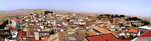
Troia, Apulia
- Italian comune
Hiking in Troia, Apulia
Troia is a charming town located in the Apulia region of southern Italy, known for its rich history and beautiful landscapes. Hiking in and around Troia offers a mix of cultural experiences and natural beauty, making it a great destination for outdoor enthusiasts. Here are some highlights for hiking in this area:...
- Country:
- Postal Code: 71029
- Local Dialing Code: 0881
- Licence Plate Code: FG
- Coordinates: 41° 22' 0" N, 15° 18' 0" E
- GPS tracks (wikiloc): [Link]
- AboveSeaLevel: 439 м m
- Area: 168.25 sq km
- Population: 7100
- Web site: [Link]
Vico del Gargano
- Italian comune
Hiking in Vico del Gargano
Vico del Gargano is a picturesque town located in the Apulia region of Italy, surrounded by the beautiful landscapes of the Gargano National Park. Hiking in this area offers a blend of stunning coastal views, lush forests, and charming rural landscapes. Here are some highlights and tips for hiking in Vico del Gargano:...
- Country:
- Postal Code: 71018
- Local Dialing Code: 0884
- Licence Plate Code: FG
- Coordinates: 41° 51' 0" N, 15° 57' 23" E
- GPS tracks (wikiloc): [Link]
- AboveSeaLevel: 462 м m
- Area: 111.08 sq km
- Population: 7674
- Web site: [Link]


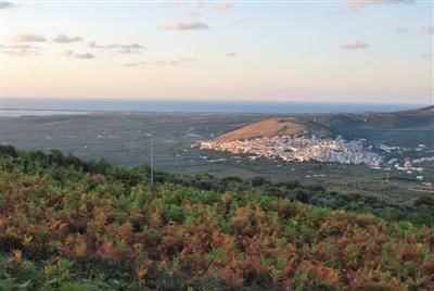
Vieste
- Italian comune
Hiking in Vieste
Vieste, located in the Gargano National Park in the Apulia region of Italy, offers a stunning backdrop for hiking enthusiasts. The combination of dramatic coastlines, lush forests, and charming historical sites makes it an attractive destination for outdoor activities....
- Country:
- Postal Code: 71019
- Local Dialing Code: 0884
- Licence Plate Code: FG
- Coordinates: 41° 53' 0" N, 16° 10' 0" E
- GPS tracks (wikiloc): [Link]
- AboveSeaLevel: 43 м m
- Area: 169.19 sq km
- Population: 13943
- Web site: [Link]


Volturara Appula
- Italian comune
Hiking in Volturara Appula
Volturara Appula is a quaint village located in the Apulia region of Italy, known for its beautiful landscapes and rich history. Hiking in and around Volturara Appula can offer a unique blend of natural beauty, cultural heritage, and adventure....
- Country:
- Postal Code: 71030
- Local Dialing Code: 0881
- Licence Plate Code: FG
- Coordinates: 41° 30' 0" N, 15° 3' 0" E
- GPS tracks (wikiloc): [Link]
- AboveSeaLevel: 510 м m
- Area: 52 sq km
- Population: 401
- Web site: [Link]


Volturino
- Italian comune
Hiking in Volturino
Hiking in Volturino, located in the Apennine Mountains of Italy, offers a wonderful opportunity to experience stunning landscapes, rich biodiversity, and a taste of the local culture. The area is known for its beautiful trails that wind through forests, past waterfalls, and up to panoramic viewpoints....
- Country:
- Postal Code: 71030
- Local Dialing Code: 0881
- Licence Plate Code: FG
- Coordinates: 41° 29' 0" N, 15° 7' 0" E
- GPS tracks (wikiloc): [Link]
- AboveSeaLevel: 735 м m
- Area: 58.35 sq km
- Population: 1679
- Web site: [Link]


Zapponeta
- Italian comune
Hiking in Zapponeta
Zapponeta is a charming village located in the Apulia region of southern Italy, along the Adriatic coast. While it may not be as widely recognized as some other hiking destinations, it offers opportunities for outdoor enthusiasts to enjoy the natural beauty of the surrounding areas....
- Country:
- Postal Code: 71030
- Local Dialing Code: 0884
- Licence Plate Code: FG
- Coordinates: 41° 27' 0" N, 15° 58' 0" E
- GPS tracks (wikiloc): [Link]
- AboveSeaLevel: 10 м m
- Area: 41.75 sq km
- Population: 3464
- Web site: [Link]
Shares border with regions:

Province of Avellino
- province in Italy
Hiking in Province of Avellino
The Province of Avellino, located in the Campania region of southern Italy, offers a variety of stunning hiking opportunities, thanks to its picturesque landscapes, mountainous terrain, and rich natural and cultural heritage. Here are some highlights and tips for hiking in this beautiful area:...
- Country:
- Capital: Avellino
- Postal Code: 83010–83059; 83100
- Local Dialing Code: 0827; 0825; 0824; 081
- Licence Plate Code: AV
- Coordinates: 40° 54' 55" N, 14° 47' 23" E
- GPS tracks (wikiloc): [Link]
- Area: 2791.64 sq km
- Population: 427310
- Web site: [Link]

Province of Barletta-Andria-Trani
- province of Italy
Hiking in Province of Barletta-Andria-Trani
The Province of Barletta-Andria-Trani, located in the Apulia region of southern Italy, is known for its scenic landscapes, rich history, and beautiful coastal areas, making it a fantastic destination for hiking enthusiasts. Here are some key highlights and suggestions for hiking in this province:...
- Country:
- Capital: Trani
- Postal Code: 76121 Barletta - 76123 Andria - 76125 Trani, 76011-76017 altri comuni.
- Licence Plate Code: BT
- Coordinates: 41° 19' 0" N, 16° 17' 0" E
- GPS tracks (wikiloc): [Link]
- Area: 1542.95 sq km
- Web site: [Link]

Benevento Province
- province of Italy
Hiking in Benevento Province
The Province of Benevento, located in the Campania region of Italy, offers a variety of hiking opportunities set against a backdrop of stunning landscapes, historical sites, and natural beauty. Here are some key highlights about hiking in this area:...
- Country:
- Capital: Benevento
- Postal Code: 82010; 82100
- Local Dialing Code: 0824; 0823
- Licence Plate Code: BN
- Coordinates: 41° 8' 0" N, 14° 47' 0" E
- GPS tracks (wikiloc): [Link]
- Area: 2070.63 sq km
- Web site: [Link]


Province of Campobasso
- province of Italy
Hiking in Province of Campobasso
The Province of Campobasso, located in the Molise region of Italy, offers a range of hiking opportunities for both beginners and experienced trekkers. The area is characterized by its stunning landscapes, which include mountains, forests, and picturesque villages. Here are some highlights to consider for hiking in this region:...
- Country:
- Capital: Campobasso
- Postal Code: 86049; 86010; 86100
- Local Dialing Code: 0875; 0874
- Licence Plate Code: CB
- Coordinates: 41° 34' 0" N, 14° 40' 0" E
- GPS tracks (wikiloc): [Link]
- Area: 2908.80 sq km
- Web site: [Link]

Province of Potenza
- province of Italy
Hiking in Province of Potenza
Hiking in the Province of Potenza offers a diverse array of landscapes, making it an appealing destination for outdoor enthusiasts. Located in the Basilicata region of southern Italy, Potenza features mountains, hills, and scenic valleys that present numerous hiking opportunities. Here are some highlights for hiking in this area:...
- Country:
- Capital: Potenza
- Postal Code: 85010–85059; 85100
- Local Dialing Code: 0976; 0975; 0973; 0972; 0971
- Licence Plate Code: PZ
- Coordinates: 40° 38' 19" N, 15° 48' 8" E
- GPS tracks (wikiloc): [Link]
- Area: 6548.49 sq km
- Web site: [Link]