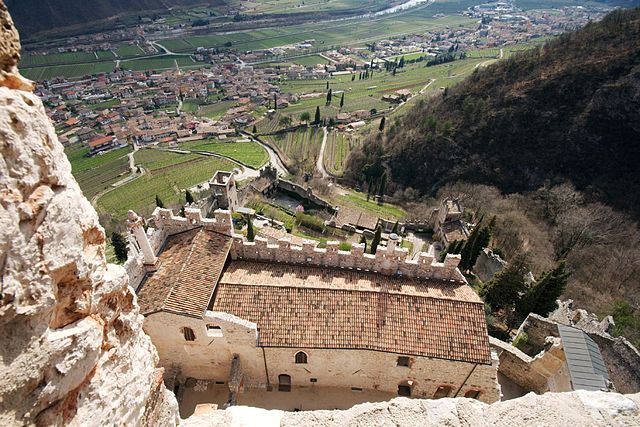
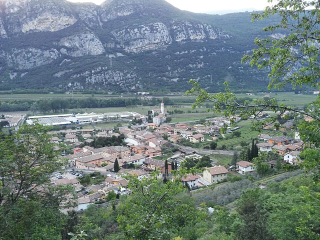
Sant'Anna d'Alfaedo (Sant'Anna d'Alfaedo)
.svg)
- Italian comune
 Hiking in Sant'Anna d'Alfaedo
Sant'Anna d'Alfaedo is a beautiful village located in the Province of Verona, in the northern Italian region of Veneto. This area is part of the Lessini Mountains, which are known for their stunning landscapes, diverse wildlife, and numerous hiking trails. Here are some key points about hiking in Sant'Anna d'Alfaedo:
Scenic Trails
- Variety of Trails: The region offers a range of hiking trails suitable for different skill levels, from easy walks to more challenging hikes that require a good level of fitness.
- Breathtaking Views: Many trails provide panoramic views of the Lessini Mountains and the surrounding valleys. Hiking here can yield picturesque vistas, especially during sunrise and sunset.
Nature and Wildlife
- Flora and Fauna: As you hike, you'll encounter diverse vegetation, including lush forests, meadows filled with wildflowers, and rocky terrains. Keep an eye out for local wildlife, including deer, foxes, and various bird species.
- Caves and Geological Features: The area is also known for its geological formations, including several interesting caves that can be explored on certain trails.
Cultural Aspects
- Local Heritage: The village itself is rich in history and culture, often featuring traditional architecture and local cuisine. Hiking can also lead you to historical landmarks and charming hamlets.
- Agricultural Landscape: Hikes may take you through vineyards and farmland, allowing for an appreciation of local agricultural practices.
Accessibility
- Trail Information: The trails are marked, and information boards are usually available at trailheads. Maps can often be obtained at local tourist information centers.
- Guided Tours: If you prefer a knowledgeable guide, local hiking organizations might offer guided tours, providing insights into the natural and cultural aspects of the area.
Best Time to Hike
- Spring and Fall: These seasons offer mild weather and vibrant colors, making them ideal for hiking.
- Summer: While hiking is popular, the temperatures can be warmer, so early morning or late afternoon hikes are recommended.
- Winter: Some trails may be suitable for winter hiking, particularly with the possibility of snow. However, check local conditions and safety recommendations.
Essential Gear
- Footwear: Sturdy hiking boots with good grip are essential, especially on uneven trails.
- Weather Protection: Always check the weather before heading out and consider layers, as conditions can change rapidly in mountainous areas.
- Hydration and Snacks: Bring plenty of water and snacks to keep your energy up during hikes.
When planning a hike in Sant'Anna d'Alfaedo, be sure to respect nature, follow local guidelines, and enjoy the stunning landscapes that this hidden gem offers!
- Country:

- Postal Code: 37020
- Local Dialing Code: 045
- Licence Plate Code: VR
- Coordinates: 45° 38' 0" N, 10° 57' 0" E


- GPS tracks (wikiloc): [Link]
- AboveSeaLevel: 939 м m
- Area: 43.43 sq km
- Population: 2535
- Web site: http://www.comune.santannadalfaedo.verona.it/
- Wikipedia en: wiki(en)
- Wikipedia: wiki(it)
- Wikidata storage: Wikidata: Q47442
- Wikipedia Commons Category: [Link]
- Freebase ID: [/m/0gb377]
- GeoNames ID: Alt: [6540378]
- VIAF ID: Alt: [238773803]
- OSM relation ID: [45419]
- ISTAT ID: 023078
- Italian cadastre code: I292
Shares border with regions:


Ala
- Italian comune
Hiking in Ala
Ala, located in the Trentino region of northern Italy, is a great base for hiking enthusiasts. Nestled in the Vallagarina valley, it offers a variety of trails that range from easy walks to more challenging hikes, all set against the backdrop of stunning landscapes, vineyards, and historical sites....
- Country:
- Postal Code: 38061
- Local Dialing Code: 0464
- Licence Plate Code: TN
- Coordinates: 45° 45' 0" N, 11° 0' 0" E
- GPS tracks (wikiloc): [Link]
- AboveSeaLevel: 210 м m
- Area: 119.87 sq km
- Population: 8887
- Web site: [Link]

Avio
- Italian comune
Hiking in Avio
Avio, located in the province of Trentino in northern Italy, is a fantastic destination for hiking enthusiasts. Nestled in the picturesque Adige Valley, it offers a variety of trails that cater to different skill levels, all while surrounded by breathtaking landscapes that feature mountains, vineyards, and historical sites....
- Country:
- Postal Code: 38063
- Local Dialing Code: 0464
- Licence Plate Code: TN
- Coordinates: 45° 44' 0" N, 10° 57' 0" E
- GPS tracks (wikiloc): [Link]
- AboveSeaLevel: 131 м m
- Area: 68.9 sq km
- Population: 4091
- Web site: [Link]


Negrar
- Italian comune
Hiking in Negrar
Negrar is a charming town located in the Valpolicella region of northern Italy, known for its beautiful landscapes, vineyards, and rich cultural heritage. It offers excellent opportunities for hiking enthusiasts, particularly those who enjoy exploring scenic trails amidst nature and stunning views....
- Country:
- Postal Code: 37024
- Local Dialing Code: 045
- Licence Plate Code: VR
- Coordinates: 45° 32' 0" N, 10° 56' 0" E
- GPS tracks (wikiloc): [Link]
- AboveSeaLevel: 190 м m
- Area: 40.42 sq km
- Population: 16935
- Web site: [Link]


Fumane
- Italian comune
Hiking in Fumane
Fumane is a charming area located in the Veneto region of northern Italy, known for its beautiful landscapes, vineyards, and rich archaeological history. It is situated near the Valpolicella region, which is famous for its wine production, and close to the natural wonder of the Lessinia Plateau....
- Country:
- Postal Code: 37022
- Local Dialing Code: 045
- Licence Plate Code: VR
- Coordinates: 45° 32' 35" N, 10° 52' 54" E
- GPS tracks (wikiloc): [Link]
- AboveSeaLevel: 198 м m
- Area: 34.21 sq km
- Population: 4151
- Web site: [Link]

Dolcè
- Italian comune
Hiking in Dolcè
Dolcè is a small village located in the province of Verona, Italy, nestled in the beautiful surroundings of the Lessinia Regional Park. This area is characterized by its stunning landscapes, charming rural architecture, and a variety of hiking trails that cater to different skill levels. Here are some key points about hiking in Dolcè:...
- Country:
- Postal Code: 37020
- Local Dialing Code: 045
- Licence Plate Code: VR
- Coordinates: 45° 36' 0" N, 10° 51' 0" E
- GPS tracks (wikiloc): [Link]
- AboveSeaLevel: 115 м m
- Area: 30.95 sq km
- Population: 2575
- Web site: [Link]
Erbezzo
- Italian comune
Hiking in Erbezzo
Erbezzo is a charming village nestled in the Lessinia region of the Veneto, Italy. It offers a variety of scenic hiking opportunities that can cater to different skill levels, making it a great destination for outdoor enthusiasts....
- Country:
- Postal Code: 37020
- Local Dialing Code: 045
- Licence Plate Code: VR
- Coordinates: 45° 38' 23" N, 11° 0' 2" E
- GPS tracks (wikiloc): [Link]
- AboveSeaLevel: 1118 м m
- Area: 31.97 sq km
- Population: 722
- Web site: [Link]


Grezzana
- Italian comune
Hiking in Grezzana
Grezzana is a picturesque village located in the Veneto region of Italy, near Verona. It's surrounded by beautiful landscapes, making it a great destination for hiking enthusiasts. Here are some details about hiking in and around Grezzana:...
- Country:
- Postal Code: 37020; 37023
- Local Dialing Code: 045
- Licence Plate Code: VR
- Coordinates: 45° 31' 0" N, 11° 1' 0" E
- GPS tracks (wikiloc): [Link]
- AboveSeaLevel: 169 м m
- Area: 49.49 sq km
- Population: 10805
- Web site: [Link]


Marano di Valpolicella
- Italian comune
Hiking in Marano di Valpolicella
Marano di Valpolicella, located in the Veneto region of Italy, is a picturesque area known for its beautiful landscapes, vineyards, and historic charm. It offers a range of hiking opportunities that appeal to both novice and experienced hikers. Here are some highlights for hiking in this region:...
- Country:
- Postal Code: 37020
- Local Dialing Code: 045
- Licence Plate Code: VR
- Coordinates: 45° 33' 0" N, 10° 55' 0" E
- GPS tracks (wikiloc): [Link]
- AboveSeaLevel: 318 м m
- Area: 18.62 sq km
- Population: 3145
- Web site: [Link]