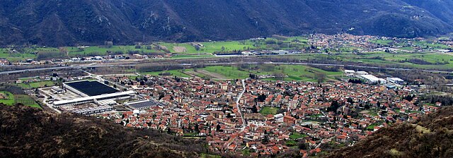
Sant'Antonino di Susa (Sant'Antonino di Susa)

- Italian comune
 Hiking in Sant'Antonino di Susa
Sant'Antonino di Susa is located in the Susa Valley of the Piedmont region in northern Italy, and it's known for its stunning natural landscapes and outdoor recreational opportunities, particularly hiking. The area is rich in history, culture, and scenic vistas, making it an attractive destination for hikers of all abilities.
Hiking Highlights in Sant'Antonino di Susa:
-
Variety of Trails: The Susa Valley offers a range of hiking trails that vary in difficulty, from easy walks suitable for families to challenging routes for experienced hikers. Most trails are well-marked and accessible.
-
Panoramic Views: Many trails provide breathtaking views of the surrounding mountains, valleys, and traditional alpine villages. Look for viewpoints along the trails that offer the best photo opportunities.
-
Natural Landmarks: Hikers can explore various natural features, including rivers, forests, and waterfalls. The area is home to diverse flora and fauna, and birdwatchers may spot unique species along their routes.
-
Cultural Sites: Along some hiking paths, you may encounter historical sites, such as old churches, ruins, and castles that reflect the rich history of the region.
-
Alpine Flora: The region is known for its diverse plant life, especially during spring and summer when many wildflowers bloom, adding vibrant colors to the landscapes.
-
Access to Higher Routes: Sant'Antonino serves as a gateway to higher elevation hikes in the nearby mountain ranges, including the Gran Paradiso National Park and the Susa Alps, which are ideal for more experienced hikers looking for alpine challenges.
-
Seasonal Considerations: The best time for hiking in this area is typically from late spring through early autumn. Snow can be prevalent in winter, impacting accessibility to certain trails.
Practical Tips:
-
Equipment: Bring proper hiking gear, including boots, weather-appropriate clothing, and a backpack with water and snacks.
-
Maps and Guides: Consider obtaining local maps or hiring a guide for more challenging trails to enhance your hiking experience and ensure you stay on the right path.
-
Weather Awareness: Be aware of the weather conditions before heading out, as mountain weather can change rapidly.
-
Local Information: Stop by local tourist information centers to get the latest updates on trail conditions and recommendations for specific hikes.
Whether you're looking for a leisurely stroll through scenic valleys or a more strenuous climb up the mountains, Sant'Antonino di Susa offers a wealth of hiking opportunities surrounded by stunning natural beauty.
- Country:

- Postal Code: 10050
- Local Dialing Code: 011
- Licence Plate Code: TO
- Coordinates: 45° 6' 25" N, 7° 16' 20" E


- GPS tracks (wikiloc): [Link]
- Area: 9.79 sq km
- Population: 4251
- Web site: http://www.comune.santantoninodisusa.to.it/
- Wikipedia en: wiki(en)
- Wikipedia: wiki(it)
- Wikidata storage: Wikidata: Q10292
- Wikipedia Commons Category: [Link]
- Freebase ID: [/m/0g8lxz]
- GeoNames ID: Alt: [6541436]
- VIAF ID: Alt: [148095093]
- OSM relation ID: [44157]
- TGN ID: [7041013]
- UN/LOCODE: [ITSA7]
- ISTAT ID: 001256
- Italian cadastre code: I296
Shares border with regions:


Vaie
- Italian comune
Hiking in Vaie
Vaie is a picturesque village located in the Dolomites region of northern Italy, in the province of Trento. This area is known for its stunning alpine scenery, rich woodlands, and numerous hiking trails suitable for outdoor enthusiasts of varying skill levels. Here are some key points to consider if you're planning to hike in Vaie:...
- Country:
- Postal Code: 10050
- Local Dialing Code: 011
- Licence Plate Code: TO
- Coordinates: 45° 6' 8" N, 7° 17' 22" E
- GPS tracks (wikiloc): [Link]
- Area: 7.23 sq km
- Population: 1456
- Web site: [Link]


Villar Focchiardo
- Italian comune
Hiking in Villar Focchiardo
Villar Focchiardo is a beautiful destination for hiking enthusiasts located in the Piedmont region of Italy, not far from the larger city of Turin. This area is characterized by its stunning natural landscapes, including lush valleys, rolling hills, and various flora and fauna. Here’s what you need to know about hiking in Villar Focchiardo:...
- Country:
- Postal Code: 10050
- Local Dialing Code: 011
- Licence Plate Code: TO
- Coordinates: 45° 7' 0" N, 7° 14' 0" E
- GPS tracks (wikiloc): [Link]
- Area: 25.69 sq km
- Population: 1987
- Web site: [Link]


Borgone Susa
- Italian comune
Hiking in Borgone Susa
Borgone Susa is a charming village located in the Susa Valley in the Piedmont region of Italy. Surrounded by the breathtaking peaks of the Alps, it offers a variety of hiking opportunities that cater to different skill levels, making it an ideal destination for both beginner and experienced hikers....
- Country:
- Postal Code: 10050
- Local Dialing Code: 011
- Licence Plate Code: TO
- Coordinates: 45° 7' 23" N, 7° 14' 28" E
- GPS tracks (wikiloc): [Link]
- AboveSeaLevel: 394 м m
- Area: 4.96 sq km
- Population: 2205
- Web site: [Link]


Coazze
- Italian comune
Hiking in Coazze
Coazze, a charming village located in the Susa Valley in the Piedmont region of Italy, offers a variety of hiking opportunities that cater to all levels of experience. The surrounding landscape features lush forests, stunning mountain views, and picturesque trails, making it a great destination for outdoor enthusiasts....
- Country:
- Postal Code: 10050
- Local Dialing Code: 011
- Licence Plate Code: TO
- Coordinates: 45° 3' 7" N, 7° 18' 2" E
- GPS tracks (wikiloc): [Link]
- AboveSeaLevel: 750 м m
- Area: 56.57 sq km
- Population: 3203
- Web site: [Link]

Condove
- Italian comune
Hiking in Condove
Condove is a small town located in the Susa Valley, within the Piedmont region of Italy. It's surrounded by stunning natural scenery, making it a wonderful spot for hiking and outdoor activities. The area is characterized by its picturesque landscapes, including the impressive peaks of the Susa Alps....
- Country:
- Postal Code: 10055
- Local Dialing Code: 011
- Licence Plate Code: TO
- Coordinates: 45° 7' 0" N, 7° 19' 0" E
- GPS tracks (wikiloc): [Link]
- AboveSeaLevel: 376 м m
- Area: 71.11 sq km
- Population: 4614
- Web site: [Link]