Santes (Santes)

- commune in Nord, France
- Country:

- Postal Code: 59211
- Coordinates: 50° 35' 36" N, 2° 57' 44" E


- GPS tracks (wikiloc): [Link]
- Area: 7.57 sq km
- Population: 5811
- Web site: http://www.santes.fr/
- Wikipedia en: wiki(en)
- Wikipedia: wiki(fr)
- Wikidata storage: Wikidata: Q665107
- Wikipedia Commons Category: [Link]
- Freebase ID: [/m/03h2b37]
- Freebase ID: [/m/03h2b37]
- GeoNames ID: Alt: [2976108]
- GeoNames ID: Alt: [2976108]
- SIREN number: [215905530]
- SIREN number: [215905530]
- BnF ID: [15267125r]
- BnF ID: [15267125r]
- VIAF ID: Alt: [143226950]
- VIAF ID: Alt: [143226950]
- GND ID: Alt: [4251453-8]
- GND ID: Alt: [4251453-8]
- Library of Congress authority ID: Alt: [n95045950]
- Library of Congress authority ID: Alt: [n95045950]
- WOEID: [620966]
- WOEID: [620966]
- INSEE municipality code: 59553
- INSEE municipality code: 59553
Shares border with regions:


Beaucamps-Ligny
- commune in Nord, France
- Country:
- Postal Code: 59134
- Coordinates: 50° 36' 17" N, 2° 55' 0" E
- GPS tracks (wikiloc): [Link]
- Area: 5.04 sq km
- Population: 857
- Web site: [Link]


Haubourdin
- commune in Nord, France
- Country:
- Postal Code: 59320
- Coordinates: 50° 36' 33" N, 2° 59' 13" E
- GPS tracks (wikiloc): [Link]
- Area: 5.31 sq km
- Population: 14804
- Web site: [Link]

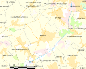
Wavrin
- commune in Nord, France
- Country:
- Postal Code: 59136
- Coordinates: 50° 34' 26" N, 2° 56' 20" E
- GPS tracks (wikiloc): [Link]
- Area: 13.55 sq km
- Population: 7656
- Web site: [Link]

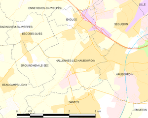
Hallennes-lez-Haubourdin
- commune in Nord, France
- Country:
- Postal Code: 59320
- Coordinates: 50° 36' 48" N, 2° 57' 34" E
- GPS tracks (wikiloc): [Link]
- AboveSeaLevel: 18 м m
- Area: 4.35 sq km
- Population: 4144
- Web site: [Link]


Houplin-Ancoisne
- commune in Nord, France
- Country:
- Postal Code: 59263
- Coordinates: 50° 33' 49" N, 3° 0' 6" E
- GPS tracks (wikiloc): [Link]
- Area: 6.48 sq km
- Population: 3470
- Web site: [Link]