Santo Stefano di Cadore (Santo Stefano di Cadore)
.svg)
- Italian comune
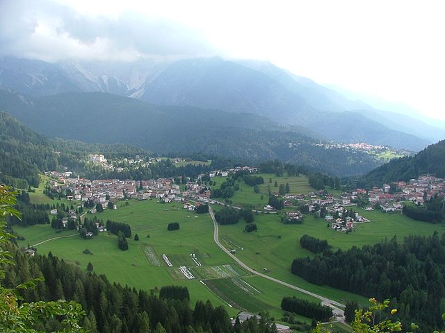
 Hiking in Santo Stefano di Cadore
Santo Stefano di Cadore is a charming town located in the Dolomite region of Italy, known for its stunning landscapes, lush valleys, and impressive mountain ranges. The area offers a variety of hiking trails suited for different skill levels, making it an excellent destination for hiking enthusiasts.
Trails & Routes
-
Alta Via 1: This renowned long-distance trail traverses the Dolomites and passes through the surrounding area of Santo Stefano di Cadore. It offers breathtaking views, with opportunities to experience rich flora and fauna.
-
Path of the Old Miners (Sentiero dei Minatori): This trail leads through historic mining areas, allowing hikers to explore the region's history while enjoying panoramic views of the valley and surrounding mountains.
-
Forcella Figara: A moderate hike that offers stunning views of the Cadore area. This trail typically takes around 3 to 4 hours, and it's suitable for those with some hiking experience.
-
Lago di Centro Cadore: A scenic lake that is accessible via shorter trails, perfect for families or beginners. The area around the lake is ideal for picnics and enjoying the natural beauty.
-
Skiing and Snowshoeing Trails: In winter, many of the summer hiking trails transform into routes for snowshoeing and cross-country skiing, providing year-round outdoor opportunities.
Best Time to Hike
- Summer (June to September): Ideal for hiking, with good weather and fully accessible trails.
- Autumn (October): Great for witnessing the fall colors, but weather can be unpredictable.
- Winter: Perfect for snow sports, though hiking requires special equipment like snowshoes.
Tips for Hiking in Santo Stefano di Cadore
- Gear Up: Wear sturdy hiking boots and dress in layers. Conditions can change rapidly in the mountains.
- Stay Hydrated: Carry enough water, especially on longer hikes.
- Maps & GPS: Always have a map or a GPS device, as trails may not be well-marked.
- Local Guidance: Consider hiring a local guide for more challenging routes or to learn about the area’s history and ecosystems.
Accommodations and Amenities
Santo Stefano di Cadore offers various accommodation options, from hotels to guesthouses and campsites, making it easy to find a base for your hiking adventures. Local restaurants also serve traditional dishes, providing a taste of the region's culture after a day on the trails.
Overall, Santo Stefano di Cadore is a fantastic destination for hikers, combining natural beauty, cultural heritage, and a welcoming atmosphere in the heart of the Dolomites.
- Country:

- Postal Code: 32045
- Local Dialing Code: 0435
- Licence Plate Code: BL
- Coordinates: 46° 34' 0" N, 12° 33' 0" E


- GPS tracks (wikiloc): [Link]
- AboveSeaLevel: 908 м m
- Area: 100.62 sq km
- Population: 2511
- Web site: http://www.santostefanodicadore.info/
- Wikipedia en: wiki(en)
- Wikipedia: wiki(it)
- Wikidata storage: Wikidata: Q40790
- Wikipedia Commons Category: [Link]
- Freebase ID: [/m/0dzp_j]
- GeoNames ID: Alt: [6538287]
- VIAF ID: Alt: [241857638]
- OSM relation ID: [47253]
- ISTAT ID: 025050
- Italian cadastre code: C919
Shares border with regions:
Untertilliach
- municipality in Austria
Hiking in Untertilliach
Untertilliach is a picturesque village located in the Lesachtal Valley of Austria, known for its stunning alpine scenery and extensive hiking opportunities. Nestled in the heart of the eastern Alps, the area is a paradise for nature lovers and hikers....
- Country:

- Postal Code: 9943
- Local Dialing Code: 04847
- Licence Plate Code: LZ
- Coordinates: 46° 42' 13" N, 12° 40' 39" E
- GPS tracks (wikiloc): [Link]
- AboveSeaLevel: 1235 м m
- Area: 36.3 sq km
- Population: 237

Vigo di Cadore
- Italian comune
Hiking in Vigo di Cadore
Vigo di Cadore is a picturesque village in the Dolomites, located in the Veneto region of Italy. It’s an excellent starting point for hiking enthusiasts due to its stunning landscapes, diverse trails, and rich natural and cultural heritage. Here are some highlights about hiking in Vigo di Cadore:...
- Country:
- Postal Code: 32040
- Local Dialing Code: 0435
- Licence Plate Code: BL
- Coordinates: 46° 30' 0" N, 12° 28' 0" E
- GPS tracks (wikiloc): [Link]
- AboveSeaLevel: 947 м m
- Area: 70.07 sq km
- Population: 1409
- Web site: [Link]


Auronzo di Cadore
- Italian comune
Hiking in Auronzo di Cadore
Auronzo di Cadore is a stunning destination located in the Dolomites of northeastern Italy, known for its breathtaking landscapes, rich history, and a plethora of outdoor activities, particularly hiking. Here’s an overview of what to expect when hiking in Auronzo di Cadore:...
- Country:
- Postal Code: 32041
- Local Dialing Code: 0435
- Licence Plate Code: BL
- Coordinates: 46° 33' 0" N, 12° 26' 0" E
- GPS tracks (wikiloc): [Link]
- AboveSeaLevel: 862 м m
- Area: 220.65 sq km
- Population: 3302
- Web site: [Link]
San Nicolò di Comelico
- Italian comune
Hiking in San Nicolò di Comelico
San Nicolò di Comelico is a picturesque village situated in the Dolomites of Italy, offering stunning hiking opportunities against a backdrop of breathtaking mountain landscapes, lush forests, and tranquil alpine meadows. Here are some highlights and considerations for hiking in this area:...
- Country:
- Postal Code: 32040
- Local Dialing Code: 0435
- Licence Plate Code: BL
- Coordinates: 46° 34' 55" N, 12° 31' 42" E
- GPS tracks (wikiloc): [Link]
- AboveSeaLevel: 1061 м m
- Area: 24.16 sq km
- Population: 390
- Web site: [Link]


Danta di Cadore
- Italian comune
Hiking in Danta di Cadore
Danta di Cadore is a beautiful mountain village located in the Dolomites, Northeast Italy. It's known for its picturesque landscapes, charming architecture, and numerous hiking opportunities suitable for various skill levels. Here are some highlights and tips for hiking in this area:...
- Country:
- Postal Code: 32040
- Local Dialing Code: 0435
- Licence Plate Code: BL
- Coordinates: 46° 34' 1" N, 12° 31' 14" E
- GPS tracks (wikiloc): [Link]
- AboveSeaLevel: 1398 м m
- Area: 7.95 sq km
- Population: 446
- Web site: [Link]


San Pietro di Cadore
- Italian comune
Hiking in San Pietro di Cadore
San Pietro di Cadore is a picturesque village located in the Cadore region of the Dolomites in northern Italy. This area is renowned for its stunning alpine scenery, rich culture, and numerous outdoor activities, making it an excellent destination for hiking enthusiasts....
- Country:
- Postal Code: 32040
- Local Dialing Code: 0435
- Licence Plate Code: BL
- Coordinates: 46° 34' 0" N, 12° 35' 0" E
- GPS tracks (wikiloc): [Link]
- AboveSeaLevel: 1100 м m
- Area: 52.13 sq km
- Population: 1601
- Web site: [Link]


Forni Avoltri
- commune and town in Italy
Hiking in Forni Avoltri
Forni Avoltri is a charming village located in the Friuli Venezia Giulia region of northeastern Italy, surrounded by the stunning landscapes of the Carnic Alps. The area is well-known for its beautiful hiking trails, which cater to a variety of skill levels, from beginners to more experienced hikers....
- Country:
- Postal Code: 33020
- Local Dialing Code: 0433
- Licence Plate Code: UD
- Coordinates: 46° 35' 0" N, 12° 47' 0" E
- GPS tracks (wikiloc): [Link]
- AboveSeaLevel: 888 м m
- Area: 80.75 sq km
- Population: 562
- Web site: [Link]

Lesachtal
- municipality in Austria
Hiking in Lesachtal
Lesachtal is a picturesque valley located in the Austrian Alps, primarily in Carinthia, and is known for its stunning natural landscapes, traditional villages, and a variety of hiking trails suited for different skill levels. Here’s what you can expect when hiking in Lesachtal:...
- Country:
- Local Dialing Code: 04716
- Licence Plate Code: HE
- Coordinates: 46° 41' 38" N, 12° 48' 57" E
- GPS tracks (wikiloc): [Link]
- AboveSeaLevel: 1043 м m
- Area: 190.69 sq km
- Population: 1318
- Web site: [Link]


Obertilliach
- place and municipality in Tyrol, Austria
Hiking in Obertilliach
Obertilliach is a picturesque village located in the East Tyrol region of Austria, surrounded by the stunning landscapes of the Lienz Dolomites and the Carnic Alps. It's an excellent destination for hikers of all levels, offering a mix of well-marked trails, breathtaking views, and a serene environment. Here are some highlights you can expect while hiking in and around Obertilliach:...
- Country:
- Postal Code: 9942
- Local Dialing Code: 04847
- Licence Plate Code: LZ
- Coordinates: 46° 42' 31" N, 12° 36' 58" E
- GPS tracks (wikiloc): [Link]
- AboveSeaLevel: 1450 м m
- Area: 65.13 sq km
- Population: 666
- Web site: [Link]