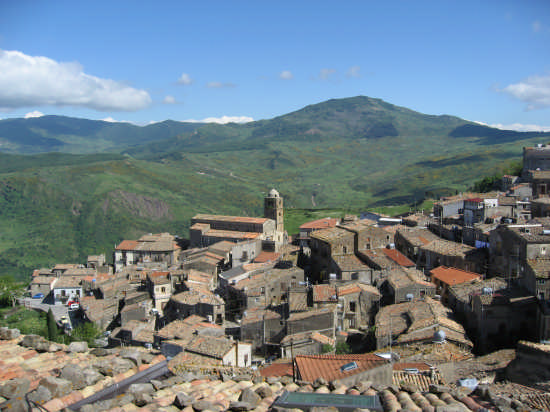
Santo Stefano di Camastra (Santo Stefano di Camastra)
.svg)
- Italian comune
 Hiking in Santo Stefano di Camastra
Santo Stefano di Camastra, located in Sicily, Italy, is known for its picturesque landscapes and rich cultural heritage. Hiking in this area offers a variety of trails that showcase the natural beauty of the surrounding landscape, which includes views of the Tyrrhenian Sea and the Nebrodi Mountains.
Key Hiking Areas and Trails:
-
Nebrodi National Park:
- This park is nearby and provides extensive trails for hikers. The park is known for its diverse flora and fauna, lush forests, and stunning vistas.
- Trails vary in difficulty, from easy walks to challenging hikes, making it suitable for hikers of all levels.
-
Mount San Calogero:
- A prominent peak near Santo Stefano di Camastra that offers a challenging hike with rewarding views. The trail takes you through varied terrain and is an excellent spot for more experienced hikers looking for adventure.
-
Coastal Trails:
- There are scenic coastal paths that allow hikers to enjoy the beauty of the Mediterranean Sea. These trails are generally less strenuous and great for families or those looking for a leisurely hike.
- Be prepared for some sections that may be rocky or sandy, depending on the specific route.
-
Cultural Attractions:
- While hiking, you can also explore local cultural sites such as the town's famous ceramics and historical architecture. Incorporating these stops into your hike can enhance your experience.
Preparation Tips:
- Weather: Check the weather conditions before heading out, as they can change rapidly, especially in mountainous areas.
- Gear: Wear sturdy hiking shoes, and pack plenty of water, snacks, and sunscreen.
- Local Guidance: Consider hiring a local guide if you are unfamiliar with the area or if you want to learn more about the local ecology and history.
When to Go:
- The best times to hike in Santo Stefano di Camastra are in the spring (April to June) and fall (September to October) when the temperatures are mild and the landscapes are at their most vibrant.
Safety Considerations:
- Always inform someone of your hiking plans and expected return time.
- Make sure to stick to marked trails and pay attention to local wildlife.
Hiking in Santo Stefano di Camastra can be a rewarding experience, combining physical activity with the exploration of Sicily's natural and cultural richness.
- Country:

- Postal Code: 98077
- Local Dialing Code: 0921
- Licence Plate Code: ME
- Coordinates: 38° 1' 0" N, 14° 21' 0" E


- GPS tracks (wikiloc): [Link]
- AboveSeaLevel: 70 м m
- Area: 21.92 sq km
- Population: 4670
- Web site: http://www.comune.santostefanodicamastra.me.it/
- Wikipedia en: wiki(en)
- Wikipedia: wiki(it)
- Wikidata storage: Wikidata: Q494809
- Wikipedia Commons Category: [Link]
- Freebase ID: [/m/0gqfbv]
- GeoNames ID: Alt: [6539165]
- VIAF ID: Alt: [167729056]
- OSM relation ID: [39456]
- GND ID: Alt: [4118350-2]
- Library of Congress authority ID: Alt: [nr89012149]
- UN/LOCODE: [ITTEF]
- ISTAT ID: 083091
- Italian cadastre code: I370
Shares border with regions:


Reitano
- Italian comune
Hiking in Reitano
Reitano is a charming village located in Sicily, Italy, surrounded by picturesque landscapes and rugged terrain, making it a great destination for hiking enthusiasts. The area is characterized by its natural beauty, including hills, valleys, and views of the nearby coastline. Here are some highlights and tips for hiking in and around Reitano:...
- Country:
- Postal Code: 98070
- Local Dialing Code: 0921
- Licence Plate Code: ME
- Coordinates: 37° 58' 0" N, 14° 21' 0" E
- GPS tracks (wikiloc): [Link]
- AboveSeaLevel: 396 м m
- Area: 14.12 sq km
- Population: 779
- Web site: [Link]

Mistretta
- Italian comune
Hiking in Mistretta
Mistretta, a charming medieval town located in the heart of Sicily, Italy, offers various hiking opportunities that allow you to experience the area's natural beauty and rich history. The surrounding Madonie Mountains are especially popular among hikers, providing a range of trails suitable for all experience levels....
- Country:
- Postal Code: 98073
- Local Dialing Code: 0921
- Coordinates: 37° 56' 0" N, 14° 22' 0" E
- GPS tracks (wikiloc): [Link]
- AboveSeaLevel: 950 м m
- Area: 127.47 sq km
- Population: 4639
- Web site: [Link]


Caronia
- Italian comune
Hiking in Caronia
Caronia, a small coastal town in Sicily, Italy, is a great place for hiking enthusiasts who appreciate stunning landscapes and a rich cultural backdrop. While the town itself may not have extensive marked trails, the surrounding areas offer a variety of hiking opportunities....
- Country:
- Postal Code: 98072
- Local Dialing Code: 0921
- Licence Plate Code: ME
- Coordinates: 38° 1' 0" N, 14° 26' 0" E
- GPS tracks (wikiloc): [Link]
- AboveSeaLevel: 304 м m
- Area: 227.26 sq km
- Population: 3279
- Web site: [Link]