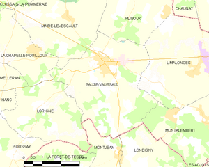
Sauzé-Vaussais (Sauzé-Vaussais)
- commune in Deux-Sèvres, France
- Country:

- Postal Code: 79190
- Coordinates: 46° 8' 7" N, 0° 6' 18" E


- GPS tracks (wikiloc): [Link]
- Area: 19.08 sq km
- Population: 1626
- Web site: https://www.mairie-sauze-vaussais.fr/
- Wikipedia en: wiki(en)
- Wikipedia: wiki(fr)
- Wikidata storage: Wikidata: Q1467299
- Wikipedia Commons Category: [Link]
- Freebase ID: [/m/03mg4g8]
- GeoNames ID: Alt: [2975612]
- SIREN number: [217903079]
- BnF ID: [152764397]
- Library of Congress authority ID: Alt: [no2003038420]
- PACTOLS thesaurus ID: [pcrtHgaV14ToNS]
- MusicBrainz area ID: [4a43d557-0bc1-4931-a24d-2530da11960d]
- WOEID: [621350]
- INSEE municipality code: 79307
Shares border with regions:
La Chapelle-Pouilloux
- commune in Deux-Sèvres, France
- Country:

- Postal Code: 79190
- Coordinates: 46° 8' 17" N, 0° 3' 18" E


- GPS tracks (wikiloc): [Link]
- Area: 7.85 sq km
- Population: 183


Limalonges
- commune in Deux-Sèvres, France
- Country:

- Postal Code: 79190
- Coordinates: 46° 7' 48" N, 0° 10' 8" E


- GPS tracks (wikiloc): [Link]
- Area: 24.39 sq km
- Population: 844
- Web site: [Link]
Mairé-Levescault
- commune in Deux-Sèvres, France
- Country:

- Postal Code: 79190
- Coordinates: 46° 9' 15" N, 0° 4' 53" E


- GPS tracks (wikiloc): [Link]
- AboveSeaLevel: 145 м m
- Area: 17.38 sq km
- Population: 559
- Web site: [Link]


Lorigné
- commune in Deux-Sèvres, France
- Country:

- Postal Code: 79190
- Coordinates: 46° 6' 36" N, 0° 3' 39" E


- GPS tracks (wikiloc): [Link]
- Area: 11.1 sq km
- Population: 296
- Web site: [Link]


Montjean
- commune in Charente, France
- Country:

- Postal Code: 16240
- Coordinates: 46° 5' 15" N, 0° 7' 10" E


- GPS tracks (wikiloc): [Link]
- Area: 8.01 sq km
- Population: 237

Londigny
- commune in Charente, France
- Country:

- Postal Code: 16700
- Coordinates: 46° 4' 59" N, 0° 8' 13" E


- GPS tracks (wikiloc): [Link]
- Area: 9.67 sq km
- Population: 249
Montalembert
- commune in Deux-Sèvres, France
- Country:

- Postal Code: 79190
- Coordinates: 46° 6' 38" N, 0° 9' 27" E


- GPS tracks (wikiloc): [Link]
- Area: 11.8 sq km
- Population: 273


Pliboux
- commune in Deux-Sèvres, France
- Country:

- Postal Code: 79190
- Coordinates: 46° 10' 4" N, 0° 7' 38" E


- GPS tracks (wikiloc): [Link]
- Area: 15.29 sq km
- Population: 208
