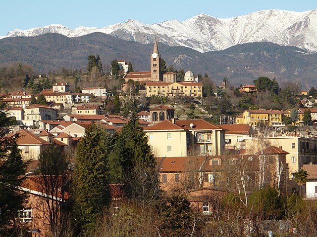
Scalenghe (Scalenghe)

- Italian comune
 Hiking in Scalenghe
Scalenghe is a small town located in the Piedmont region of Italy, not far from Turin. While it might not be as well-known for hiking as some larger mountain areas, there are still opportunities for outdoor enthusiasts to explore the natural beauty of the surrounding countryside.
Hiking Opportunities in and Around Scalenghe:
-
Natural Landscapes: The area around Scalenghe features rolling hills, vineyards, and agricultural fields, which can provide some pleasant, scenic walks. You might find trails that lead through these pastoral landscapes.
-
Nearby Parks and Reserves: The nearby Parco Naturale dei Laghi di Avigliana and the Val di Susa offer more extensive hiking opportunities. These areas are known for their stunning mountain scenery, and trails suited for various skill levels.
-
Cultural Routes: Consider walking along historical or cultural routes that may take you through nearby towns, vineyards, or historical sites. These can enrich your hiking experience by introducing you to local culture and history.
-
Trail Recommendations:
- Via Francigena: Portions of this ancient pilgrimage route pass through the region, offering beautiful paths and a chance to experience historical sites along the way.
- Local Trails: Check local tourist information for detailed maps and suggestions on shorter trails that can be easily accessed from Scalenghe.
-
Skills and Preparation: As always, ensure you’re well-prepared for your hike—carry sufficient water, wear appropriate footwear, and check the weather in advance. Also, since the area might not have extensive signage, a good map or GPS app can be helpful.
Tips:
- Local Guides: Hiring a local guide can provide insight into the area's flora, fauna, and history while safely navigating the trails.
- Seasonal Considerations: Spring and fall are typically the best times to hike in this region due to milder temperatures and vibrant scenery.
If you're planning a hiking trip around Scalenghe, you'll enjoy a combination of beautiful landscapes, cultural experiences, and a chance to appreciate the serene Italian countryside!
- Country:

- Postal Code: 10060
- Local Dialing Code: 011
- Licence Plate Code: TO
- Coordinates: 44° 53' 34" N, 7° 29' 37" E


- GPS tracks (wikiloc): [Link]
- AboveSeaLevel: 262 м m
- Area: 31.68 sq km
- Population: 3279
- Web site: http://www.comune.scalenghe.to.it/
- Wikipedia en: wiki(en)
- Wikipedia: wiki(it)
- Wikidata storage: Wikidata: Q10298
- Wikipedia Commons Category: [Link]
- Freebase ID: [/m/0g8l_s]
- GeoNames ID: Alt: [6541439]
- OSM relation ID: [43761]
- TGN ID: [7040130]
- UN/LOCODE: [ITSLH]
- ISTAT ID: 001260
- Italian cadastre code: I490
Shares border with regions:
Piscina
- Italian comune
Hiking in Piscina
Piscina, located in the Piedmont region of northern Italy, is a charming destination for hiking enthusiasts. Nestled in the foothills of the Alps, it offers a variety of trails that showcase scenic landscapes, dense forests, and sparkling streams....
- Country:
- Postal Code: 10060
- Local Dialing Code: 0121
- Licence Plate Code: TO
- Coordinates: 44° 55' 0" N, 7° 26' 0" E
- GPS tracks (wikiloc): [Link]
- AboveSeaLevel: 288 м m
- Area: 9.9 sq km
- Population: 3364
- Web site: [Link]


Airasca
- Italian comune of the Province of Turin in the Piedmont region
Hiking in Airasca
Airasca is a small town located in the Piedmont region of Italy, not far from Turin. While it may not be a well-known hiking destination, there are several opportunities for outdoor enthusiasts to enjoy nature in the surrounding areas....
- Country:
- Postal Code: 10060
- Local Dialing Code: 011
- Licence Plate Code: TO
- Coordinates: 44° 55' 0" N, 7° 29' 0" E
- GPS tracks (wikiloc): [Link]
- AboveSeaLevel: 257 м m
- Area: 15.74 sq km
- Population: 3726
- Web site: [Link]


Buriasco
- Italian comune
Hiking in Buriasco
Buriasco is a small municipality located in the province of Turin, in the Piedmont region of Italy. While it may not be as well-known as some of the larger hiking destinations, it offers various opportunities for outdoor enthusiasts, especially for those who enjoy exploring less crowded natural areas....
- Country:
- Postal Code: 10060
- Local Dialing Code: 0121
- Licence Plate Code: TO
- Coordinates: 44° 52' 0" N, 7° 25' 0" E
- GPS tracks (wikiloc): [Link]
- AboveSeaLevel: 301 м m
- Area: 14.69 sq km
- Population: 1370
- Web site: [Link]
Castagnole Piemonte
- Italian comune
Hiking in Castagnole Piemonte
Castagnole Piemonte is a charming municipality located in the Piedmont region of Italy, not far from Turin. Nestled in the fertile plains, it offers a mix of flat terrain and rolling hills, making it an ideal locale for various hiking experiences, even if it's not as mountainous as other parts of Italy....
- Country:
- Postal Code: 10060
- Local Dialing Code: 011
- Licence Plate Code: TO
- Coordinates: 44° 54' 0" N, 7° 34' 0" E
- GPS tracks (wikiloc): [Link]
- AboveSeaLevel: 244 м m
- Area: 17.28 sq km
- Population: 2246
- Web site: [Link]


Cercenasco
- Italian comune
Hiking in Cercenasco
Cercenasco, a municipality in the Metropolitan City of Turin in Italy, offers a beautiful setting for hiking enthusiasts looking to explore the natural beauty of the Piedmont region. The area is characterized by rolling hills, picturesque landscapes, and a rich variety of flora and fauna....
- Country:
- Postal Code: 10060
- Local Dialing Code: 011
- Licence Plate Code: TO
- Coordinates: 44° 52' 0" N, 7° 30' 0" E
- GPS tracks (wikiloc): [Link]
- AboveSeaLevel: 256 м m
- Area: 13.16 sq km
- Population: 1803
- Web site: [Link]


None
- Italian comune
Hiking in None
None, a small town in the Piedmont region of Italy, offers a charming backdrop for hiking enthusiasts. While it may not be as well-known as larger destinations, its proximity to the stunning landscapes of the surrounding areas makes it a worthwhile spot for hiking....
- Country:
- Postal Code: 10060
- Local Dialing Code: 011
- Licence Plate Code: TO
- Coordinates: 44° 56' 0" N, 7° 32' 0" E
- GPS tracks (wikiloc): [Link]
- AboveSeaLevel: 245 м m
- Area: 24.64 sq km
- Population: 8015
- Web site: [Link]

Pinerolo
- Italian comune
Hiking in Pinerolo
Pinerolo, located in the Piedmont region of Italy, is surrounded by beautiful mountainous terrain, making it a fantastic destination for hiking enthusiasts. Here are some key points about hiking in Pinerolo:...
- Country:
- Postal Code: 10064
- Local Dialing Code: 0121
- Licence Plate Code: TO
- Coordinates: 44° 53' 0" N, 7° 20' 0" E
- GPS tracks (wikiloc): [Link]
- AboveSeaLevel: 376 м m
- Area: 50.34 sq km
- Population: 35947
- Web site: [Link]