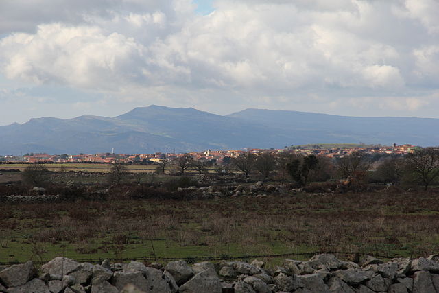
Scano di Montiferro (Scano di Montiferro)
%20-%202016.svg)
- Italian comune
 Hiking in Scano di Montiferro
Scano di Montiferro is a beautiful destination located in the province of Oristano, Sardinia, Italy. It's known for its stunning landscapes, rich history, and a variety of hiking opportunities suitable for different skill levels.
Hiking Trails
-
Montiferro Park Trails: The area is surrounded by rugged terrain and offers several trails in the Montiferro Regional Park. Trails vary in difficulty and length, providing options for both beginners and more experienced hikers.
-
The Path of the Ancient Nuragic Settlements: Some trails take you through the remnants of ancient Nuragic civilization, where you can explore archaeological sites and enjoy breathtaking views from rocky outcrops.
-
Forest Trails: There are paths winding through beautiful forests of oaks and Mediterranean scrub, ideal for those who enjoy nature and birdwatching. These areas are also perfect for relaxing and having a picnic.
Tips for Hiking in Scano di Montiferro
- Preparation: Always plan your hike according to your skill level. Carry a map and be aware of the trail conditions.
- Weather Check: Before heading out, check the weather forecast. Sardinian weather can change rapidly, especially in mountainous areas.
- Footwear: Wear sturdy hiking boots with good grip, as the terrain can be rocky and uneven.
- Hydration: Bring adequate water, especially during the warmer months. There may not be many water sources along the trails.
- Local Guides: If you're unfamiliar with the area, consider hiring a local guide who can provide insights into the landscape and history of Scano di Montiferro.
Best Time to Hike
The best times for hiking in Scano di Montiferro are typically in spring (April to June) and fall (September to October) when temperatures are mild, and the landscapes are lush and vibrant.
Additional Attractions
Besides hiking, Scano di Montiferro offers cultural experiences, including traditional Sardinian cuisine and local festivals. Don't miss the chance to explore the nearby villages, where you can learn about local traditions and crafts.
Overall, hiking in Scano di Montiferro is a rewarding experience, combining stunning natural beauty with rich cultural heritage. Enjoy your adventure!
- Country:

- Postal Code: 09078
- Local Dialing Code: 0785
- Licence Plate Code: OR
- Coordinates: 40° 12' 54" N, 8° 35' 14" E


- GPS tracks (wikiloc): [Link]
- AboveSeaLevel: 385 м m
- Area: 60.47 sq km
- Population: 1493
- Web site: https://www.comune.scanodimontiferro.or.it
- Wikipedia en: wiki(en)
- Wikipedia: wiki(it)
- Wikidata storage: Wikidata: Q387730
- Wikipedia Commons Category: [Link]
- Freebase ID: [/m/0gr0z2]
- GeoNames ID: Alt: [6542276]
- VIAF ID: Alt: [144498600]
- OSM relation ID: [40345]
- Library of Congress authority ID: Alt: [nb2004302859]
- ISTAT ID: 095051
- Italian cadastre code: I503
Shares border with regions:


Sagama
- Italian comune
Hiking in Sagama
Sagama, located in the beautiful mountainous regions of Japan, offers a variety of hiking trails that cater to different skill levels, from beginners to seasoned hikers. The region is known for its stunning landscapes, including lush forests, steep mountain paths, and breathtaking views....
- Country:
- Postal Code: 08010
- Local Dialing Code: 0785
- Licence Plate Code: OR
- Coordinates: 40° 15' 40" N, 8° 34' 39" E
- GPS tracks (wikiloc): [Link]
- AboveSeaLevel: 347 м m
- Area: 11.72 sq km
- Population: 199
- Web site: [Link]


Borore
- Italian comune
Hiking in Borore
Borore, a locality in Sardinia, Italy, offers a rich landscape for hiking enthusiasts. The area is known for its stunning natural beauty, diverse terrain, and cultural heritage. Here are some highlights for hiking in Borore:...
- Country:
- Postal Code: 08016
- Local Dialing Code: 0785
- Licence Plate Code: NU
- Coordinates: 40° 12' 55" N, 8° 48' 11" E
- GPS tracks (wikiloc): [Link]
- AboveSeaLevel: 394 м m
- Area: 42.68 sq km
- Population: 2079
- Web site: [Link]


Macomer
- Italian comune
Hiking in Macomer
Macomer, situated in the province of Nuoro on the island of Sardinia, Italy, is surrounded by beautiful landscapes that make it a great location for hiking enthusiasts. Here are some highlights and tips for hiking in and around Macomer:...
- Country:
- Postal Code: 08015
- Local Dialing Code: 0785
- Licence Plate Code: NU
- Coordinates: 40° 15' 52" N, 8° 46' 30" E
- GPS tracks (wikiloc): [Link]
- AboveSeaLevel: 550 м m
- Area: 122.77 sq km
- Population: 10019
- Web site: [Link]

Sindia, Sardinia
- Italian comune
Hiking in Sindia, Sardinia
Sardinia, an island in Italy, offers a wealth of stunning hiking opportunities, and Siniscola, located in the eastern part of the island, is a wonderful place to explore. Here are some highlights and tips for hiking in this area:...
- Country:
- Postal Code: 08018
- Local Dialing Code: 0785
- Licence Plate Code: NU
- Coordinates: 40° 17' 41" N, 8° 39' 27" E
- GPS tracks (wikiloc): [Link]
- AboveSeaLevel: 509 м m
- Area: 58.57 sq km
- Population: 1701
- Web site: [Link]


Cuglieri
- Italian comune
Hiking in Cuglieri
Cuglieri is a charming town located in the province of Oristano, Sardinia, Italy. It's set against a stunning backdrop of natural beauty, including mountainous terrain, coastal views, and rich Mediterranean vegetation, making it an excellent destination for hiking enthusiasts....
- Country:
- Postal Code: 09073
- Local Dialing Code: 0785
- Licence Plate Code: OR
- Coordinates: 40° 11' 20" N, 8° 34' 2" E
- GPS tracks (wikiloc): [Link]
- AboveSeaLevel: 479 м m
- Area: 120.6 sq km
- Population: 3146
- Web site: [Link]


Flussio
- Italian comune
Hiking in Flussio
Flussio is a small town located in the northern part of Sardinia, Italy. The region surrounding Flussio offers beautiful natural scenery and various hiking opportunities, ideal for both novice and experienced hikers. Here’s what you can expect when hiking in and around Flussio:...
- Country:
- Postal Code: 08010
- Local Dialing Code: 0785
- Licence Plate Code: OR
- Coordinates: 40° 16' 2" N, 8° 32' 21" E
- GPS tracks (wikiloc): [Link]
- AboveSeaLevel: 305 м m
- Area: 6.87 sq km
- Population: 433
- Web site: [Link]


Santu Lussurgiu
- Italian comune
Hiking in Santu Lussurgiu
Santu Lussurgiu is a beautiful town in the province of Oristano, Sardinia, known for its stunning landscapes and rich cultural heritage. Hiking in and around Santu Lussurgiu offers a fantastic opportunity to explore the natural beauty of the region, including its mountains, forests, and picturesque countryside....
- Country:
- Postal Code: 09075
- Local Dialing Code: 0783
- Licence Plate Code: OR
- Coordinates: 40° 8' 31" N, 8° 39' 7" E
- GPS tracks (wikiloc): [Link]
- AboveSeaLevel: 503 м m
- Area: 99.8 sq km
- Population: 2372
- Web site: [Link]


Sennariolo
- Italian comune
Hiking in Sennariolo
Sennariolo is a charming village located in the province of Nuoro in Sardinia, Italy, known for its stunning landscapes and rich cultural heritage. Hiking in and around Sennariolo offers visitors a unique opportunity to explore the natural beauty of the region, including rocky terrain, lush greenery, and panoramic views....
- Country:
- Postal Code: 09078
- Local Dialing Code: 0785
- Licence Plate Code: OR
- Coordinates: 40° 12' 44" N, 8° 33' 23" E
- GPS tracks (wikiloc): [Link]
- AboveSeaLevel: 274 м m
- Area: 15.61 sq km
- Population: 186
- Web site: [Link]