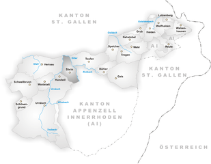
Schlatt-Haslen (Schlatt-Haslen)

- municipality in Switzerland
 Hiking in Schlatt-Haslen
Schlatt-Haslen is a picturesque area located in the canton of Appenzell Innerrhoden, Switzerland. Renowned for its beautiful landscapes, rolling hills, and traditional Swiss charm, it's a wonderful destination for hiking and outdoor activities.
Hiking Highlights in Schlatt-Haslen
-
Scenic Trails: The region offers a variety of trails suitable for different skill levels, ranging from easy walks to more challenging hikes. The paths often provide stunning views of the surrounding mountains and lush valleys.
-
Nature and Wildlife: As you hike, you may encounter diverse flora and fauna typical of the Swiss countryside. Keep an eye out for local wildlife, and enjoy the serenity of nature.
-
Cultural Experience: In addition to the natural landscape, hiking in Schlatt-Haslen allows you to experience traditional Swiss culture. You might pass by charming villages and farms, where you can learn about local customs and perhaps taste some regional delicacies.
-
Accessibility: The area is accessible by public transport, making it easy to reach from nearby cities like Appenzell. Most trails are well-marked, allowing for easy navigation.
-
Seasonal Beauty: Each season offers a unique experience; spring brings blooming wildflowers, summer is perfect for clear skies and warm temperatures, autumn showcases vibrant foliage, and winter can be magical with snow-covered landscapes.
Recommended Hikes
- Local Nature Trails: Explore well-marked nature trails that guide you through beautiful forests and meadows.
- Hilltop Hikes: Trails leading up to hilltops provide panoramic views of the Appenzell Alps and the surrounding landscape.
- Family-friendly Routes: There are several easy trails that are perfect for families with children or less experienced hikers.
Tips for Hiking in Schlatt-Haslen
- Check Weather Conditions: Always check the weather before heading out, as conditions can change rapidly in the mountains.
- Wear Appropriate Footwear: Good hiking boots are essential to navigate various terrains safely.
- Bring Supplies: Carry enough water, snacks, and a basic first-aid kit.
- Follow Local Guidelines: Respect any posted signs and guidelines to preserve the natural environment.
Whether you are an experienced hiker or just looking for a tranquil walk in nature, Schlatt-Haslen offers a delightful hiking experience in a stunning Swiss setting.
- Country:

- Postal Code: 9050
- Local Dialing Code: 071
- Licence Plate Code: AI
- Coordinates: 47° 21' 24" N, 9° 23' 46" E


- GPS tracks (wikiloc): [Link]
- AboveSeaLevel: 740 м m
- Area: 17.92 sq km
- Population: 1126
- Web site: http://www.schlatt-haslen.ch
- Wikipedia en: wiki(en)
- Wikipedia: wiki(de)
- Wikidata storage: Wikidata: Q64301
- Wikipedia Commons Category: [Link]
- Freebase ID: [/m/01vbzm]
- GeoNames ID: Alt: [7287088]
- VIAF ID: Alt: [248292787]
- OSM relation ID: [1683932]
- archINFORM location ID: [45196]
- HDS ID: [1316]
- Swiss municipality code: [3104]
Shares border with regions:


Gonten
- municipality in Switzerland
Hiking in Gonten
Gonten is a picturesque village located in the Appenzell Innerrhoden region of Switzerland, known for its stunning landscapes and charming Swiss countryside. The area offers a variety of hiking opportunities suitable for all levels, from leisurely walks to more challenging mountain routes....
- Country:
- Postal Code: 9108
- Local Dialing Code: 071
- Licence Plate Code: AI
- Coordinates: 47° 19' 9" N, 9° 20' 55" E
- GPS tracks (wikiloc): [Link]
- AboveSeaLevel: 1007 м m
- Area: 24.61 sq km
- Population: 1455
- Web site: [Link]


Gais
- municipality in Switzerland
Hiking in Gais
Gais, a charming village in the Appenzell Innerrhoden region of Switzerland, offers stunning hiking opportunities suitable for various skill levels. The surrounding landscapes are characterized by rolling hills, lush meadows, and spectacular mountain views, making it a paradise for outdoor enthusiasts....
- Country:
- Postal Code: 9056
- Local Dialing Code: 071
- Licence Plate Code: AR
- Coordinates: 47° 21' 38" N, 9° 27' 4" E
- GPS tracks (wikiloc): [Link]
- AboveSeaLevel: 983 м m
- Area: 21.23 sq km
- Population: 3096
- Web site: [Link]

Stein
- municipality in Switzerland
Hiking in Stein
Hiking in Stein, located in the Appenzell region of Switzerland, offers a fantastic experience surrounded by stunning landscapes, rolling hills, and mountainous terrain. This area is known for its picturesque scenery, vibrant green meadows, and traditional Swiss chalets, making it a perfect destination for outdoor enthusiasts....
- Country:
- Postal Code: 9063
- Local Dialing Code: 071
- Licence Plate Code: AR
- Coordinates: 47° 22' 36" N, 9° 20' 30" E
- GPS tracks (wikiloc): [Link]
- AboveSeaLevel: 800 м m
- Area: 9.37 sq km
- Population: 1423
- Web site: [Link]


Bühler
- municipality in Switzerland
Hiking in Bühler
Bühler is a beautiful area known for its stunning landscapes and hiking opportunities. Whether you're looking for leisurely walks or more challenging trails, Bühler offers a variety of options for outdoor enthusiasts....
- Country:
- Postal Code: 9055
- Local Dialing Code: 071
- Licence Plate Code: AR
- Coordinates: 47° 22' 22" N, 9° 25' 16" E
- GPS tracks (wikiloc): [Link]
- AboveSeaLevel: 824 м m
- Area: 5.61 sq km
- Population: 1766
- Web site: [Link]


Teufen
- municipality in Switzerland
Hiking in Teufen
Teufen, located in Appenzell Ausserrhoden, Switzerland, offers a stunning setting for hiking enthusiasts. The region is characterized by beautiful meadows, rolling hills, and breathtaking views of the Appenzell Alps. Here are some highlights of hiking in this area:...
- Country:
- Postal Code: 9053
- Local Dialing Code: 071
- Licence Plate Code: AR
- Coordinates: 47° 23' 37" N, 9° 23' 19" E
- GPS tracks (wikiloc): [Link]
- AboveSeaLevel: 875 м m
- Area: 15.3 sq km
- Population: 6267
- Web site: [Link]


Hundwil
- municipality in Switzerland
Hiking in Hundwil
Hundwil is a charming village located in the Appenzell region of Switzerland, surrounded by picturesque landscapes and rolling hills, making it an excellent destination for hiking enthusiasts. The area offers a variety of well-marked trails suitable for different skill levels, from leisurely walks to more challenging hikes....
- Country:
- Postal Code: 9064
- Local Dialing Code: 071
- Licence Plate Code: AR
- Coordinates: 47° 21' 55" N, 9° 19' 10" E
- GPS tracks (wikiloc): [Link]
- AboveSeaLevel: 897 м m
- Area: 23.96 sq km
- Population: 957
- Web site: [Link]