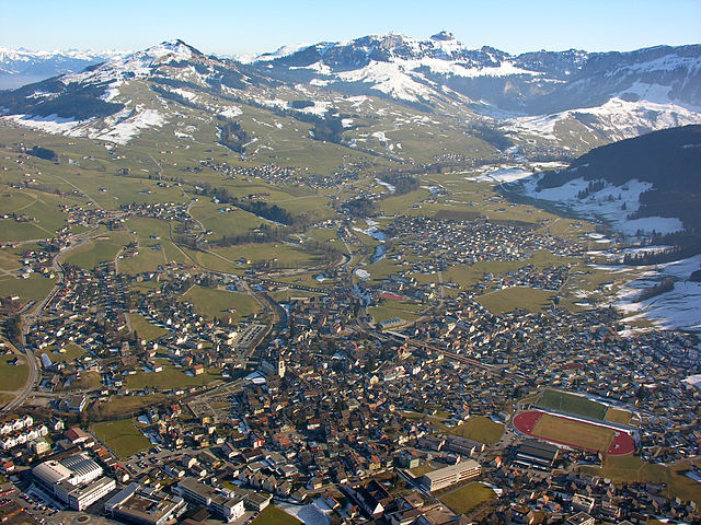
Appenzell Innerrhoden (Appenzell Innerrhoden)


- canton of Switzerland
 Hiking in Appenzell Innerrhoden
Hiking in the Canton of Appenzell Innerrhoden, located in eastern Switzerland, offers a unique opportunity to explore stunning landscapes, rich culture, and well-maintained trails. Here are some highlights and tips for hiking in this picturesque region:
Scenic Trails
-
Appenzeller Trail: This long-distance trail runs through the entire canton and offers a mix of challenging and moderate sections. Hikers will be treated to panoramic views, charming villages, and lush pastures dotted with traditional Swiss farms.
-
Hiking around the Ebenalp: A popular destination, Ebenalp is accessible via a cable car. From here, hikers can explore the legendary Wildkirchli caves, visit the Aescher cliff restaurant, and enjoy incredible views of the Appenzell region.
-
Säntis: The highest peak in the Alpstein massif, Säntis offers various hiking routes ranging from easy walks to more strenuous climbs. The summit provides breathtaking views across six countries on clear days.
-
Seealpsee: This picturesque mountain lake is a perfect spot for a leisurely hike. The trail from Wasserauen to Seealpsee is well-marked and includes beautiful landscapes, with options for picnicking by the lakeside.
Cultural Experience
The Canton of Appenzell Innerrhoden is known for its traditional Swiss culture, which you’ll experience along the hiking trails. The region is famous for its cheese production, and many hikes pass through cheese-making farms where you can taste fresh local products.
Practical Tips
- Weather: The weather can change rapidly in the Alps, so it’s essential to check forecasts before heading out. Dress in layers and carry waterproof clothing.
- Maps and Signage: Trails are well signposted, but it’s wise to carry a good hiking map or a GPS device.
- Safety: Hiking alone is possible, but it’s safer to go with a group or a partner, especially in more remote areas. Always let someone know your route and estimated return time.
- Accommodation: The region offers a range of accommodations, from cozy mountain inns to hotels in the charming town of Appenzell.
Accessibility
The trails are generally accessible from the towns of Appenzell and nearby villages, with public transportation options available to reach trailheads.
Overall, hiking in Appenzell Innerrhoden is a rewarding experience filled with natural beauty, cultural richness, and opportunities for adventure.
- Country:

- Licence Plate Code: AI
- Coordinates: 47° 18' 0" N, 9° 24' 0" E


- GPS tracks (wikiloc): [Link]
- AboveSeaLevel: 780 м m
- Area: 172.48 sq km
- Web site: http://www.ai.ch/
- Wikipedia en: wiki(en)
- Wikipedia: wiki(de)
- Wikidata storage: Wikidata: Q12094
- Wikipedia Commons Gallery: [Link]
- Wikipedia Commons Category: [Link]
- Freebase ID: [/m/01v5h1]
- GeoNames ID: Alt: [2661741]
- BnF ID: [13176661h]
- VIAF ID: Alt: [159441847]
- OSM relation ID: [373265]
- GND ID: Alt: [4002489-1]
- archINFORM location ID: [4616]
- Library of Congress authority ID: Alt: [n82039930]
- MusicBrainz area ID: [daec0765-b38e-4e74-acfc-6753ad6b7ae0]
- Quora topic ID: [Canton-of-Appenzell-Innerrhoden]
- TGN ID: [7003752]
- SUDOC authorities ID: [028991680]
- Gran Enciclopèdia Catalana ID: [0004551]
- HDS ID: [7475]
- ISNI: Alt: [0000 0001 2195 7977]
- NUTS code: [CH054]
- Ringgold ID: [325348]
- STW Thesaurus for Economics ID: [16957-4]
- ISO 3166-2 code: CH-AI
- FIPS 10-4 (countries and regions): SZ10
Includes regions:


Schlatt-Haslen
- municipality in Switzerland
Hiking in Schlatt-Haslen
Schlatt-Haslen is a picturesque area located in the canton of Appenzell Innerrhoden, Switzerland. Renowned for its beautiful landscapes, rolling hills, and traditional Swiss charm, it's a wonderful destination for hiking and outdoor activities....
- Country:
- Postal Code: 9050
- Local Dialing Code: 071
- Licence Plate Code: AI
- Coordinates: 47° 21' 24" N, 9° 23' 46" E
- GPS tracks (wikiloc): [Link]
- AboveSeaLevel: 740 м m
- Area: 17.92 sq km
- Population: 1126
- Web site: [Link]


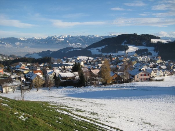
Gonten
- municipality in Switzerland
Hiking in Gonten
Gonten is a picturesque village located in the Appenzell Innerrhoden region of Switzerland, known for its stunning landscapes and charming Swiss countryside. The area offers a variety of hiking opportunities suitable for all levels, from leisurely walks to more challenging mountain routes....
- Country:
- Postal Code: 9108
- Local Dialing Code: 071
- Licence Plate Code: AI
- Coordinates: 47° 19' 9" N, 9° 20' 55" E
- GPS tracks (wikiloc): [Link]
- AboveSeaLevel: 1007 м m
- Area: 24.61 sq km
- Population: 1455
- Web site: [Link]

Appenzell District
- municipality in Switzerland
Hiking in Appenzell District
Appenzell District, located in the eastern part of Switzerland, is renowned for its stunning landscapes, rolling hills, picturesque villages, and rich cultural heritage. It's an excellent destination for hikers of all levels, offering a variety of trails that showcase the region's natural beauty and provide access to breathtaking mountain views....
- Country:
- Postal Code: 9050
- Local Dialing Code: 071
- Licence Plate Code: AI
- Coordinates: 47° 20' 0" N, 9° 25' 0" E
- GPS tracks (wikiloc): [Link]
- AboveSeaLevel: 780 м m
- Area: 16.9 sq km
- Population: 5809
- Web site: [Link]


Rüte
- municipality in Switzerland
Hiking in Rüte
Rüte, a charming area in Switzerland, is nestled in the picturesque Appenzell region. The region is characterized by rolling hills, lush pastures, and stunning mountain views, making it a fantastic destination for hiking enthusiasts. Here are some highlights and tips for hiking in Rüte:...
- Country:
- Postal Code: 9050
- Local Dialing Code: 071
- Licence Plate Code: AI
- Coordinates: 47° 19' 14" N, 9° 25' 48" E
- GPS tracks (wikiloc): [Link]
- AboveSeaLevel: 799 м m
- Area: 40.9 sq km
- Population: 3606
- Web site: [Link]


Schwende District
- municipality in Switzerland
Hiking in Schwende District
Schwende District, located in the Appenzell Innerrhoden region of Switzerland, is a beautiful and scenic area that offers a variety of hiking opportunities. Known for its breathtaking landscapes, picturesque villages, and rich cultural heritage, this district is a great choice for hikers of all skill levels. Here are some highlights to consider when hiking in the Schwende District:...
- Country:
- Postal Code: 9057
- Local Dialing Code: 071
- Licence Plate Code: AI
- Coordinates: 47° 16' 51" N, 9° 23' 35" E
- GPS tracks (wikiloc): [Link]
- AboveSeaLevel: 1611 м m
- Area: 57.5 sq km
- Population: 2202
- Web site: [Link]
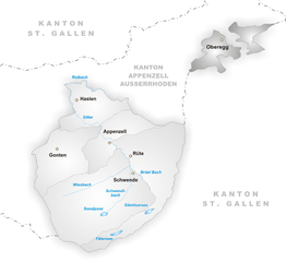
Oberegg
- municipality in Switzerland
Hiking in Oberegg
Hiking in the Oberegg District, located in the canton of Appenzell Innerrhoden in Switzerland, offers a beautiful blend of scenic landscapes, cultural experiences, and varied terrains. This area is characterized by rolling hills, lush fields, and magnificent views of the surrounding mountains, making it a perfect destination for both novice and experienced hikers....
- Country:
- Postal Code: 9413
- Local Dialing Code: 071
- Licence Plate Code: AI
- Coordinates: 47° 25' 1" N, 9° 33' 27" E
- GPS tracks (wikiloc): [Link]
- AboveSeaLevel: 885 м m
- Area: 14.7 sq km
- Population: 1907
- Web site: [Link]
Shares border with regions:


Appenzell Ausserrhoden
- canton of Switzerland
Hiking in Appenzell Ausserrhoden
Hiking in the Canton of Appenzell Ausserrhoden offers stunning landscapes, picturesque villages, and well-marked trails that cater to various skill levels. This region in Switzerland is known for its rolling hills, picturesque mountains, and scenic views of the surrounding areas....
- Country:
- Capital: Trogen
- Licence Plate Code: AR
- Coordinates: 47° 3' 0" N, 9° 1' 0" E
- GPS tracks (wikiloc): [Link]
- AboveSeaLevel: 771 м m
- Area: 242.84 sq km
- Web site: [Link]


Canton of St. Gallen
- canton of Switzerland
Hiking in Canton of St. Gallen
The Canton of St. Gallen, located in eastern Switzerland, is a fantastic destination for hiking enthusiasts, boasting a diverse range of trails that cater to various skill levels and interests. Here's an overview of what you can expect:...
- Country:
- Capital: St. Gallen
- Licence Plate Code: SG
- Coordinates: 47° 20' 0" N, 9° 10' 0" E
- GPS tracks (wikiloc): [Link]
- AboveSeaLevel: 668 м m
- Area: 2030.75 sq km
- Population: 75538
- Web site: [Link]