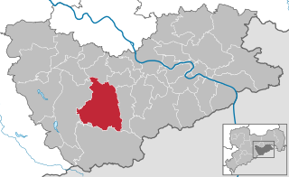
Schmiedeberg (Schmiedeberg)
- municipal subdivision of Dippoldiswalde
Schmiedeberg, located in the Saxon Switzerland region of Germany, is a picturesque area that offers a variety of hiking opportunities. This small town is nestled among stunning landscapes characterized by sandstone cliffs, dense forests, and scenic views of the Saxon countryside.
Hiking Highlights in Schmiedeberg:
-
Diverse Trail Options: The trails around Schmiedeberg cater to various skill levels, from easy walks suitable for families to more challenging hikes for experienced trekkers.
-
Saxon Switzerland National Park: Just a short distance away, the national park is famous for its unique rock formations, deep gorges, and rich biodiversity. Trails like the Bastei and Malerweg (Painter's Way) are particularly popular. The Malerweg is a long-distance trail that stretches 112 kilometers and showcases breathtaking landscapes.
-
Scenic Views: Hikers can enjoy panoramic views of the Elbe River Valley and the iconic sandstone formations. Places like the Bastei Bridge offer stunning vistas and photo opportunities.
-
Flora and Fauna: The region is rich in wildlife, and you might encounter various species of birds, deer, and other animals. The diverse vegetation adds to the beauty and enjoyment of the hikes.
-
Historical Routes: Some trails pass through historical sites, including old castles, ruins, and lovely villages, adding a cultural element to the hiking experience.
-
Accessibility: Schmiedeberg is well-connected by public transport to other hiking areas and towns, making it easy to explore different trails.
Tips for Hiking in Schmiedeberg:
- Weather Considerations: Check the weather forecast before you set out, as conditions can change quickly in mountainous regions.
- Gear Up: Wear suitable hiking gear, including good hiking boots, and consider bringing trekking poles for uneven terrain.
- Stay Hydrated and Snack: Carry enough water and snacks, especially if you’re heading out for a longer hike.
- Trail Maps and Guides: Use detailed hiking maps or mobile apps to avoid getting lost and to plan your route effectively.
Hiking in Schmiedeberg and its surrounding areas can be a truly rewarding experience, offering a mix of natural beauty and adventure. Enjoy the trails!
- Country:

- Postal Code: 01762
- Local Dialing Code: 035052
- Licence Plate Code: PIR
- Coordinates: 50° 50' 15" N, 13° 40' 31" E


- GPS tracks (wikiloc): [Link]
- AboveSeaLevel: 436 м m
- Area: 40.76 sq km
- Web site: http://www.schmiedeberg.net/
- Wikipedia en: wiki(en)
- Wikipedia: wiki(de)
- Wikidata storage: Wikidata: Q8239
- Wikipedia Commons Gallery: [Link]
- Wikipedia Commons Category: [Link]
- Freebase ID: [/m/02vz3cp]
- Freebase ID: [/m/02vz3cp]
- GeoNames ID: Alt: [2837788]
- GeoNames ID: Alt: [2837788]
- VIAF ID: Alt: [248566782]
- VIAF ID: Alt: [248566782]
- GND ID: Alt: [4440968-0]
- GND ID: Alt: [4440968-0]
Shares border with regions:


Altenberg
- municipality of Germany
Altenberg, Saxony, is a picturesque destination known for its stunning natural landscapes, making it an excellent location for hiking enthusiasts. Situated in the Ore Mountains (Erzgebirge), Altenberg offers a variety of hiking trails that cater to different skill levels and preferences....
- Country:

- Postal Code: 01778; 01773
- Local Dialing Code: 035057; 035056; 035054; 035052
- Licence Plate Code: PIR
- Coordinates: 50° 45' 52" N, 13° 45' 28" E


- GPS tracks (wikiloc): [Link]
- AboveSeaLevel: 750 м m
- Area: 145810000 sq km
- Population: 7926
- Web site: [Link]


Dippoldiswalde
- town in the Free State of Saxony, Germany
Dippoldiswalde, located in the German state of Saxony, is a lovely area for hiking enthusiasts. Nestled near the Erzgebirge (Ore Mountains), it offers beautiful landscapes, diverse trails, and rich natural scenery. Here are some highlights for hiking in and around Dippoldiswalde:...
- Country:

- Postal Code: 01744
- Local Dialing Code: 035052; 03504
- Coordinates: 50° 53' 36" N, 13° 40' 0" E


- GPS tracks (wikiloc): [Link]
- AboveSeaLevel: 375 м m
- Area: 104.13 sq km
- Population: 14405
- Web site: [Link]


Glashütte
- town in Sächsische Schweiz-Osterzgebirge, Free State of Saxony, Germany
Glashütte, located in the Saxon Switzerland region of Germany, offers a wonderful experience for hiking enthusiasts. Renowned for its striking sandstone cliffs, dense forests, and beautiful valleys, the area is part of the Saxon Switzerland National Park, which boasts numerous trails with varying degrees of difficulty, making it accessible for both beginners and experienced hikers....
- Country:

- Postal Code: 01768
- Local Dialing Code: 035053
- Licence Plate Code: PIR
- Coordinates: 50° 51' 0" N, 13° 47' 0" E


- GPS tracks (wikiloc): [Link]
- AboveSeaLevel: 340 м m
- Area: 95.57 sq km
- Population: 6691
- Web site: [Link]


Hartmannsdorf-Reichenau
- municipality in the Sächsische Schweiz-Osterzgebirge district, in Saxony, Germany
 Hiking in Hartmannsdorf-Reichenau
Hartmannsdorf-Reichenau is a picturesque area located in the Saxony region of Germany, known for its beautiful landscapes and outdoor activities. The region offers numerous hiking opportunities for various skill levels, ranging from easy walks to more challenging trails....
- Country:

- Postal Code: 01762
- Local Dialing Code: 037326
- Licence Plate Code: PIR
- Coordinates: 50° 49' 0" N, 13° 34' 30" E


- GPS tracks (wikiloc): [Link]
- AboveSeaLevel: 569 м m
- Area: 28.37 sq km
- Population: 1031
- Web site: [Link]


Hermsdorf/Erzgeb.
- municipality in the Sächsische Schweiz-Osterzgebirge district, in Saxony, Germany
Hermsdorf, located in Saxony, Germany, is a charming starting point for various hiking adventures thanks to its picturesque landscapes and proximity to the Ore Mountains (Erzgebirge). Here are some key points about hiking in and around Hermsdorf:...
- Country:

- Postal Code: 01776
- Local Dialing Code: 035057
- Licence Plate Code: PIR
- Coordinates: 50° 45' 40" N, 13° 37' 47" E


- GPS tracks (wikiloc): [Link]
- AboveSeaLevel: 720 м m
- Area: 20.06 sq km
- Population: 792
- Web site: [Link]