Scorbé-Clairvaux (Scorbé-Clairvaux)

- commune in Vienne, France
- Country:

- Postal Code: 86140
- Coordinates: 46° 48' 46" N, 0° 24' 47" E


- GPS tracks (wikiloc): [Link]
- Area: 22.85 sq km
- Population: 2281
- Web site: http://www.scorbe-clairvaux.fr
- Wikipedia en: wiki(en)
- Wikipedia: wiki(fr)
- Wikidata storage: Wikidata: Q1439932
- Wikipedia Commons Category: [Link]
- Freebase ID: [/m/03qhg_d]
- GeoNames ID: Alt: [2975400]
- SIREN number: [218602589]
- BnF ID: [15278683r]
- INSEE municipality code: 86258
Shares border with regions:

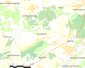
Colombiers
- commune in Vienne, France
- Country:
- Postal Code: 86490
- Coordinates: 46° 46' 20" N, 0° 25' 33" E
- GPS tracks (wikiloc): [Link]
- Area: 20.77 sq km
- Population: 1518

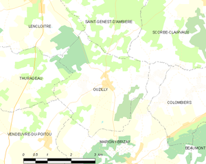
Ouzilly
- commune in Vienne, France
- Country:
- Postal Code: 86380
- Coordinates: 46° 46' 35" N, 0° 21' 42" E
- GPS tracks (wikiloc): [Link]
- Area: 10.63 sq km
- Population: 909
- Web site: [Link]


Marigny-Brizay
- former commune in Vienne, France
- Country:
- Postal Code: 86380
- Coordinates: 46° 44' 44" N, 0° 22' 33" E
- GPS tracks (wikiloc): [Link]
- Area: 20.81 sq km
- Population: 1336
- Web site: [Link]

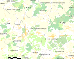
Saint-Genest-d'Ambière
- commune in Vienne, France
- Country:
- Postal Code: 86140
- Coordinates: 46° 49' 12" N, 0° 22' 3" E
- GPS tracks (wikiloc): [Link]
- Area: 32.06 sq km
- Population: 1280
- Web site: [Link]

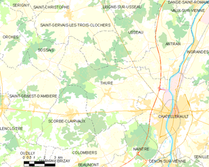
Thuré
- commune in Vienne, France
- Country:
- Postal Code: 86540
- Coordinates: 46° 49' 55" N, 0° 27' 33" E
- GPS tracks (wikiloc): [Link]
- Area: 43.47 sq km
- Population: 2885