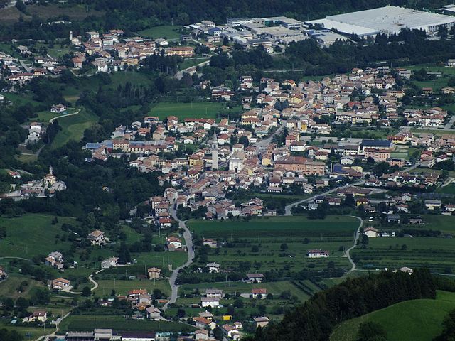
Seren del Grappa (Seren del Grappa)
.svg)
- Italian comune
 Hiking in Seren del Grappa
Seren del Grappa, located in the Veneto region of Italy, is a beautiful destination for hikers, known for its stunning landscapes and rich cultural heritage. The area is characterized by picturesque mountains, lush forests, and charming local villages. Here are some key points about hiking in Seren del Grappa:
Hiking Trails
-
Diverse Trail Options: The area offers a variety of trails, ranging from easy walks suitable for families to more challenging hikes for experienced adventurers. Trails often provide opportunities to explore the natural beauty and experience breathtaking viewpoints.
-
Panoramic Views: Many of the hikes offer panoramic views of the surrounding valleys and mountains. The scenic beauty is particularly stunning during sunrise and sunset.
-
Historical Sites: Some hiking routes will lead you to historical sites and remnants of World War I, as the region has a rich military history. You can find fortifications, trenches, and memorials along certain paths.
Best Seasons for Hiking
- Spring and Fall: These seasons are ideal for hiking in Seren del Grappa as the weather is mild, and the flora is vibrant. The autumn foliage can be particularly picturesque.
- Summer: While summer can be warm, it's also a popular time for hiking. Make sure to carry enough water and wear sun protection.
- Winter: Certain trails may be accessible for snowshoeing or winter hiking, but check local conditions and trail status beforehand.
Preparation and Tips
- Gear: Wear sturdy hiking boots and appropriate clothing. Layers are recommended, as temperatures can vary throughout the day.
- Map and Navigation: Download or carry a physical map of the area. Some trails may not be well-marked, so it’s essential to have a good sense of navigation.
- Local Guidance: Consider hiring a local guide or joining a hiking group for an enhanced experience and safety, especially if you're unfamiliar with the terrain.
Wildlife and Nature
- The area is home to diverse wildlife including deer, various bird species, and plant life. Be respectful of nature and maintain a safe distance from any wildlife you encounter.
Cultural Experience
- Take time to explore the local villages, experience the local cuisine, and interact with residents. Often, small eateries serve traditional dishes made from local ingredients.
Hiking in Seren del Grappa is not only about the physical activity but also about appreciating the stunning natural environment and immersing yourself in the rich cultural tapestry of the region. Always make sure to follow responsible hiking practices to preserve the beauty of the landscape for future visitors.
- Country:

- Postal Code: 32030
- Local Dialing Code: 0439
- Licence Plate Code: BL
- Coordinates: 45° 59' 0" N, 11° 51' 0" E


- GPS tracks (wikiloc): [Link]
- AboveSeaLevel: 385 м m
- Area: 62.53 sq km
- Population: 2448
- Web site: http://www.comune.serendelgrappa.bl.it
- Wikipedia en: wiki(en)
- Wikipedia: wiki(it)
- Wikidata storage: Wikidata: Q40799
- Wikipedia Commons Category: [Link]
- Freebase ID: [/m/0gk29d]
- GeoNames ID: Alt: [6540991]
- VIAF ID: Alt: [125954054]
- OSM relation ID: [46472]
- GND ID: Alt: [4541088-4]
- ISTAT ID: 025055
- Italian cadastre code: I626
Shares border with regions:


Feltre
- town and comune in Italy
Hiking in Feltre
Feltre is a charming town located in the Dolomites region of northern Italy, known for its beautiful landscapes, historical architecture, and a variety of hiking opportunities. Here’s a convenient guide to hiking in and around Feltre:...
- Country:
- Postal Code: 32032
- Local Dialing Code: 0439
- Licence Plate Code: BL
- Coordinates: 46° 1' 0" N, 11° 54' 0" E
- GPS tracks (wikiloc): [Link]
- AboveSeaLevel: 325 м m
- Area: 99.79 sq km
- Population: 20608
- Web site: [Link]

Alano di Piave
- Italian comune
Hiking in Alano di Piave
Alano di Piave is a picturesque town located in the province of Belluno in the Veneto region of Italy. Nestled in the foothills of the Alps, it offers stunning natural scenery, making it a great destination for hiking enthusiasts. Here are some key points to consider if you’re planning to hike in Alano di Piave:...
- Country:
- Postal Code: 32031
- Local Dialing Code: 0439
- Licence Plate Code: BL
- Coordinates: 45° 54' 26" N, 11° 54' 28" E
- GPS tracks (wikiloc): [Link]
- AboveSeaLevel: 308 м m
- Area: 36.52 sq km
- Population: 2787
- Web site: [Link]


Fonzaso
- Italian comune
Hiking in Fonzaso
Fonzaso, located in the Belluno region of northern Italy, is a beautiful destination for hiking enthusiasts. Nestled in the foothills of the Dolomites, Fonzaso offers stunning landscapes, rich flora and fauna, and a variety of trails suited for different skill levels. Here are some highlights for hiking in the area:...
- Country:
- Postal Code: 32030
- Local Dialing Code: 0439
- Licence Plate Code: BL
- Coordinates: 46° 1' 0" N, 11° 48' 0" E
- GPS tracks (wikiloc): [Link]
- AboveSeaLevel: 329 м m
- Area: 27.62 sq km
- Population: 3186
- Web site: [Link]


Arsiè
- Italian comune
Hiking in Arsiè
Arsiè is a charming town located in the province of Belluno, in the Veneto region of Italy. It is situated at the foothills of the Dolomites, making it a fantastic destination for hiking enthusiasts. The surrounding landscapes are characterized by stunning mountain scenery, lush forests, and picturesque valleys....
- Country:
- Postal Code: 32030
- Local Dialing Code: 0439
- Licence Plate Code: BL
- Coordinates: 45° 59' 0" N, 11° 45' 0" E
- GPS tracks (wikiloc): [Link]
- AboveSeaLevel: 315 м m
- Area: 64.76 sq km
- Population: 2275
- Web site: [Link]