Sermizelles (Sermizelles)

- commune in Yonne, France
- Country:

- Postal Code: 89200
- Coordinates: 47° 32' 11" N, 3° 47' 36" E


- GPS tracks (wikiloc): [Link]
- Area: 7.01 sq km
- Population: 262
- Wikipedia en: wiki(en)
- Wikipedia: wiki(fr)
- Wikidata storage: Wikidata: Q1145284
- Wikipedia Commons Category: [Link]
- Freebase ID: [/m/03qfj1h]
- Freebase ID: [/m/03qfj1h]
- GeoNames ID: Alt: [2974888]
- GeoNames ID: Alt: [2974888]
- SIREN number: [218903920]
- SIREN number: [218903920]
- BnF ID: [152798481]
- BnF ID: [152798481]
- INSEE municipality code: 89392
- INSEE municipality code: 89392
Shares border with regions:


Girolles
- commune in Yonne, France
- Country:
- Postal Code: 89200
- Coordinates: 47° 31' 56" N, 3° 50' 33" E
- GPS tracks (wikiloc): [Link]
- Area: 16.35 sq km
- Population: 178

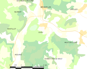
Givry
- commune in Yonne, France
- Country:
- Postal Code: 89200
- Coordinates: 47° 31' 11" N, 3° 47' 42" E
- GPS tracks (wikiloc): [Link]
- Area: 8.43 sq km
- Population: 175


Voutenay-sur-Cure
- commune in Yonne, France
- Country:
- Postal Code: 89270
- Coordinates: 47° 33' 43" N, 3° 47' 5" E
- GPS tracks (wikiloc): [Link]
- Area: 10.04 sq km
- Population: 215


Blannay
- commune in Yonne, France
- Country:
- Postal Code: 89200
- Coordinates: 47° 31' 43" N, 3° 46' 52" E
- GPS tracks (wikiloc): [Link]
- Area: 7.26 sq km
- Population: 120