Serrières (Serrières)

- commune in Saône-et-Loire, France
- Country:

- Postal Code: 71960
- Coordinates: 46° 18' 44" N, 4° 40' 47" E


- GPS tracks (wikiloc): [Link]
- Area: 9.84 sq km
- Population: 281
- Wikipedia en: wiki(en)
- Wikipedia: wiki(fr)
- Wikidata storage: Wikidata: Q1637281
- Wikipedia Commons Category: [Link]
- Wikipedia Commons Maps Category: [Link]
- Freebase ID: [/m/03qh6yk]
- GeoNames ID: Alt: [6442493]
- SIREN number: [217105188]
- INSEE municipality code: 71518
Shares border with regions:

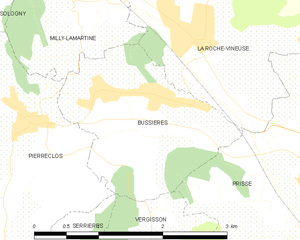
Bussières, Saône-et-Loire
- commune in Saône-et-Loire, France
- Country:
- Postal Code: 71960
- Coordinates: 46° 20' 21" N, 4° 42' 4" E
- GPS tracks (wikiloc): [Link]
- AboveSeaLevel: 250 м m
- Area: 4.08 sq km
- Population: 566


Pierreclos
- commune in Saône-et-Loire, France
- Country:
- Postal Code: 71960
- Coordinates: 46° 20' 1" N, 4° 41' 15" E
- GPS tracks (wikiloc): [Link]
- Area: 12.41 sq km
- Population: 903
- Web site: [Link]

Cenves
- commune in Rhône, France
- Country:
- Postal Code: 69840
- Coordinates: 46° 16' 5" N, 4° 38' 59" E
- GPS tracks (wikiloc): [Link]
- Area: 26.48 sq km
- Population: 407
- Web site: [Link]


Saint-Point
- commune in Saône-et-Loire, France
- Country:
- Postal Code: 71520
- Coordinates: 46° 20' 24" N, 4° 37' 1" E
- GPS tracks (wikiloc): [Link]
- Area: 14.24 sq km
- Population: 320
- Web site: [Link]