Settingiano (Settingiano)
.svg)
- Italian comune
 Hiking in Settingiano
Settingiano is a charming municipality located in the Calabria region of southern Italy, known for its scenic landscapes, rich history, and outdoor activities. While it may not be as renowned as some other hiking destinations in Italy, there are several opportunities for hiking enthusiasts in and around the area. Here are some highlights:
Hiking Trails
-
Local Trails: The surrounding countryside features a variety of trails that offer beautiful views of the hills and valleys. These trails can vary in difficulty, so it's important to choose one that matches your experience level.
-
Aspromonte National Park: A bit further afield, this national park features rugged terrain and a diverse ecosystem. You'll find trails ranging from easy walks to challenging hikes that take you to stunning vistas, waterfalls, and unique flora and fauna.
-
Sila National Park: Situated north of Settingiano, Sila offers extensive hiking options, including trails through ancient forests, around lakes, and up to mountain peaks. It’s a great place for those who enjoy both leisurely strolls and more strenuous hikes.
Tips for Hiking in Settingiano
-
Season: The best time to hike in this region is typically in spring (April to June) and fall (September to October) when temperatures are moderate, and the scenery is vibrant.
-
Gear: Proper hiking gear is essential. Make sure to wear sturdy shoes, bring plenty of water, snacks, and consider weather conditions by packing accordingly.
-
Navigation: While some trails may be marked, it's wise to carry a map or use a GPS app to stay oriented. Local hiking clubs or guides can provide valuable insights and ensure safety.
-
Cultural Sites: Take the opportunity to explore local historical sites before or after your hikes. Settingiano has various churches and monuments that reflect its rich cultural heritage.
Safety Considerations
Always let someone know your hiking plans, especially if you’re going alone. Be aware of the weather conditions, wildlife, and any potential hazards on the trails.
In summary, while Settingiano itself may not be a major hiking destination, the surrounding areas provide ample opportunities for both casual strolls and more adventurous hikes amidst beautiful Calabrian landscapes. Enjoy your outdoor adventures in this picturesque part of Italy!
- Country:

- Postal Code: 88040
- Local Dialing Code: 0961
- Licence Plate Code: CZ
- Coordinates: 38° 55' 0" N, 16° 31' 0" E


- GPS tracks (wikiloc): [Link]
- AboveSeaLevel: 170 м m
- Area: 14.35 sq km
- Population: 3159
- Web site: http://www.comune.settingiano.cz.it/
- Wikipedia en: wiki(en)
- Wikipedia: wiki(it)
- Wikidata storage: Wikidata: Q53720
- Wikipedia Commons Category: [Link]
- Freebase ID: [/m/0fhjtm]
- GeoNames ID: Alt: [6543633]
- OSM relation ID: [39733]
- TGN ID: [1046897]
- ISTAT ID: 079131
- Italian cadastre code: I704
Shares border with regions:
Catanzaro
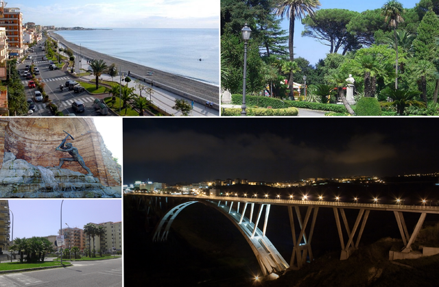
- Italian city and capital of the Calabria province
Hiking in Catanzaro
Catanzaro, located in the Calabria region of southern Italy, offers a variety of hiking opportunities that showcase its beautiful landscapes, rich history, and diverse flora and fauna. Here are some details about hiking in and around Catanzaro:...
- Country:
- Postal Code: 88100
- Local Dialing Code: 0961
- Licence Plate Code: CZ
- Coordinates: 38° 54' 36" N, 16° 35' 15" E
- GPS tracks (wikiloc): [Link]
- AboveSeaLevel: 342 м m
- Area: 112.72 sq km
- Population: 90240
- Web site: [Link]
Caraffa di Catanzaro
- Italian comune
Hiking in Caraffa di Catanzaro
Caraffa di Catanzaro is a charming town located in the Calabria region of southern Italy, known for its beautiful landscapes and proximity to various natural parks. Hiking in this area can offer a rich experience of nature, culture, and history....
- Country:
- Postal Code: 88050
- Local Dialing Code: 0961
- Licence Plate Code: CZ
- Coordinates: 38° 53' 0" N, 16° 29' 0" E
- GPS tracks (wikiloc): [Link]
- AboveSeaLevel: 450 м m
- Area: 24 sq km
- Population: 1814
- Web site: [Link]
Marcellinara
- Italian comune
Hiking in Marcellinara
Marcellinara is a quaint village located in the Calabria region of southern Italy. While it may not be as widely known as some other hiking destinations, it offers a range of outdoor activities that can be appealing to hikers and nature enthusiasts. Here are some key points to consider if you're considering hiking in and around Marcellinara:...
- Country:
- Postal Code: 88044
- Local Dialing Code: 0961
- Licence Plate Code: CZ
- Coordinates: 38° 56' 0" N, 16° 30' 0" E
- GPS tracks (wikiloc): [Link]
- AboveSeaLevel: 337 м m
- Area: 20.91 sq km
- Population: 2257
- Web site: [Link]

Tiriolo
- Italian comune
Hiking in Tiriolo
Tiriolo is a quaint village located in the Calabria region of southern Italy, known for its beautiful landscapes and diverse hiking opportunities. The area is characterized by its picturesque hills, rich forests, and magnificent views of the surrounding mountains and the Gulf of Squillace....
- Country:
- Postal Code: 88056
- Local Dialing Code: 0961
- Licence Plate Code: CZ
- Coordinates: 38° 57' 0" N, 16° 30' 0" E
- GPS tracks (wikiloc): [Link]
- AboveSeaLevel: 690 м m
- Area: 29.26 sq km
- Population: 3874
- Web site: [Link]