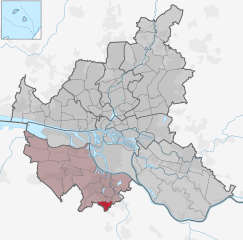
Sinstorf (Sinstorf)
- suburb in the district Harburg, Germany
Sinstorf is a neighborhood located in the city of Hamburg, Germany, known for its scenic landscapes and proximity to nature. While it may not be a typical hiking destination like national parks or mountainous regions, there are still opportunities for walking and exploring the outdoors in and around Sinstorf.
Hiking Opportunities in and Around Sinstorf:
-
Local Parks and Trails:
- Check for nearby parks where you can enjoy walking trails. Parks often have marked paths suitable for casual hikers and walkers.
- Areas like the Hamburg's Harburg district, which is close by, offer green spaces and small trails.
-
Naturpark Lüneburger Heide:
- A bit farther from Sinstorf, this natural park is well-known for its heathlands, forests, and diverse wildlife. It provides various hiking trails suitable for all skill levels.
- The area is perfect for day hikes and offers picturesque views, especially in late summer when the heather is in bloom.
-
Alte Süderelbe:
- This area along the River Elbe is characterized by beautiful paths and nature reserves. It’s great for leisurely walks and hiking in a natural riverside setting.
-
Hiking Tips:
- Always wear comfortable, sturdy footwear suitable for different terrains.
- Bring plenty of water and a map or a navigation device to avoid getting lost.
- Check the weather conditions before heading out, and dress appropriately for the climate.
-
Public Transportation:
- Use Hamburg's public transport system to reach further hiking spots. Trains and buses can take you to more extensive trail networks nearby.
-
Local Hiking Groups:
- Consider joining local hiking groups or clubs. They often have organized hikes that can enhance your experience and introduce you to other enthusiasts.
-
Safety and Environment:
- Always follow the Leave No Trace principles to protect the natural environment and wildlife.
- Stay on marked trails and respect private property.
Exploring Sinstorf and its surroundings can provide a relaxing hiking experience, even if it’s not as expansive as other hiking destinations. Think about setting off for a nearby nature reserve or national park for a more immersive outdoor experience!
- Country:

- Coordinates: 53° 25' 26" N, 9° 58' 50" E


- GPS tracks (wikiloc): [Link]
- Area: 2.6 sq km
- Wikipedia en: wiki(en)
- Wikipedia: wiki(de)
- Wikidata storage: Wikidata: Q3534
- Wikipedia Commons Category: [Link]
- Wikipedia Commons Maps Category: [Link]
- VIAF ID: Alt: [246111246]
- VIAF ID: Alt: [246111246]
- VIAF ID: Alt: [246111246]
- VIAF ID: Alt: [246111246]
- TGN ID: [7097542]
- TGN ID: [7097542]
- TGN ID: [7097542]
- TGN ID: [7097542]
Shares border with regions:


Langenbek
- quarter in the district Harburg, Germany
Langenbek is a small neighborhood located in the city of Hamburg, Germany. While it may not be widely known as a hiking destination, there are scenic spots and parks in and around Hamburg where you can enjoy hiking and nature walks. Here are some tips and information about hiking in the Langenbek area and nearby locations:...
- Country:

- Postal Code: 21079; 21075; 21073
- Coordinates: 53° 25' 53" N, 9° 59' 22" E


- GPS tracks (wikiloc): [Link]
- AboveSeaLevel: 79 м m
- Area: 0.8 sq km
- Population: 4020
- Web site: [Link]


Marmstorf
- quarter in the district Harburg, Germany
Marmstorf, while not extensively known as a hiking destination, is a suburb of Hamburg, Germany, and offers some beautiful opportunities for local walks and nature exploration. The surrounding areas of Hamburg provide access to several parks and green spaces which can make for pleasant hiking experiences. Here are some points to consider if you're looking to hike in and around Marmstorf:...
- Country:

- Coordinates: 53° 26' 9" N, 9° 58' 7" E


- GPS tracks (wikiloc): [Link]
- Area: 5.8 sq km


Rönneburg
- quarter in the district Hamburg, Germany
Rönneburg, located in northern Germany, is a charming area that offers a variety of hiking opportunities. The region is characterized by its scenic landscapes, including forests, fields, and rolling hills. Here are some highlights and tips for hiking in Rönneburg:...
- Country:

- Coordinates: 53° 26' 15" N, 10° 0' 16" E


- GPS tracks (wikiloc): [Link]
- AboveSeaLevel: 45 м m
- Area: 2.3 sq km

