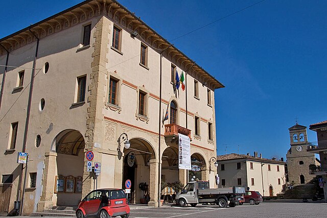
Sogliano al Rubicone (Sogliano al Rubicone)
.svg)
- Italian comune
 Hiking in Sogliano al Rubicone
Sogliano al Rubicone is a charming town located in the Emilia-Romagna region of Italy, known for its beautiful landscapes, rich history, and delicious cuisine. Hiking in this area offers a unique experience, combining natural beauty with cultural heritage.
Hiking Trails
-
Natural Landscapes: The region features rolling hills, lush forests, and scenic views of the Rubicone River. The trails here are often well-marked and vary in difficulty, catering to different skill levels.
-
Historic Paths: Many hikes pass through ancient villages and historical sites. Along the way, you can explore medieval architecture, old churches, and traditional farms.
-
Guided Hikes: Consider joining a guided hiking tour which can provide insights into the local flora, fauna, and history of the region.
Recommended Hiking Routes
-
The "Sentiero della Romagna": This is a well-known trail that runs through the hills of Romagna, showcasing fantastic views of the Rubicone valley. Sections of this trail can be accessed from Sogliano al Rubicone.
-
Local Loop Trails: Various shorter loop trails are accessible from the town, allowing for half-day hikes that can range from easy to moderate. These trails are ideal for families or those looking for a leisurely experience.
Best Time to Hike
-
Spring and Fall: These seasons offer moderate temperatures and beautiful scenery, making it ideal for hiking. The wildflowers in spring and the autumn foliage provide stunning backdrops.
-
Summer: While summer can be hot, early morning or late afternoon hikes can be enjoyable. Be sure to stay hydrated and wear appropriate sun protection.
Tips for Hiking in Sogliano al Rubicone
-
Footwear: Wear sturdy hiking shoes with good traction as some paths can be rocky or uneven.
-
Pack Essentials: Bring water, snacks, a first-aid kit, and a map or GPS device. Cell service may be limited in some areas.
-
Respect Nature: Follow the Leave No Trace principles. Stay on designated trails to protect the local ecosystem.
-
Local Cuisine: After your hike, treat yourself to local specialties. Sogliano is famous for its cheese, cured meats, and wine, making it a perfect way to end your outdoor adventure.
With its stunning landscapes and rich cultural heritage, hiking in Sogliano al Rubicone can offer a rewarding experience for both novice and experienced hikers. Enjoy your adventure!
- Country:

- Postal Code: 47030
- Local Dialing Code: 0541; 0541 - 0547
- Licence Plate Code: FC
- Coordinates: 44° 0' 0" N, 12° 18' 0" E


- GPS tracks (wikiloc): [Link]
- AboveSeaLevel: 362 м m
- Area: 93.43 sq km
- Population: 3230
- Web site: http://www.comunedisoglianocavour.gov.it
- Wikipedia en: wiki(en)
- Wikipedia: wiki(it)
- Wikidata storage: Wikidata: Q99958
- Wikipedia Commons Category: [Link]
- Freebase ID: [/m/0gkmbb]
- GeoNames ID: Alt: [6536759]
- VIAF ID: Alt: [135251673]
- OSM relation ID: [42738]
- UN/LOCODE: [ITSRU]
- ISTAT ID: 040046
- Italian cadastre code: I779
Shares border with regions:

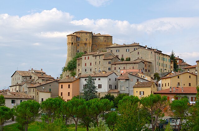
Novafeltria
- Italian comune
Hiking in Novafeltria
Novafeltria, located in the Emilia-Romagna region of Italy, is surrounded by the stunning landscapes of the Apennine Mountains. This area offers a variety of hiking opportunities for different skill levels. Here’s what you can expect when hiking in Novafeltria:...
- Country:
- Postal Code: 47863
- Local Dialing Code: 0541
- Licence Plate Code: RN
- Coordinates: 43° 53' 43" N, 12° 17' 26" E
- GPS tracks (wikiloc): [Link]
- AboveSeaLevel: 275 м m
- Area: 41.84 sq km
- Population: 7119
- Web site: [Link]

Sant'Agata Feltria
- Italian comune
Hiking in Sant'Agata Feltria
Sant'Agata Feltria is a charming town located in the Emilia-Romagna region of Italy, surrounded by beautiful natural landscapes, making it an excellent destination for hiking enthusiasts. Here’s what you should know about hiking in this area:...
- Country:
- Postal Code: 47866
- Local Dialing Code: 0547
- Licence Plate Code: RN
- Coordinates: 43° 51' 50" N, 12° 12' 31" E
- GPS tracks (wikiloc): [Link]
- AboveSeaLevel: 606 м m
- Area: 79.74 sq km
- Population: 2121
- Web site: [Link]


Talamello
- Italian comune
Hiking in Talamello
Talamello, located in the Emilia-Romagna region of Italy, is a charming destination for hiking enthusiasts. The area is characterized by its picturesque landscapes, rolling hills, and dense forests, making it ideal for a variety of hiking experiences....
- Country:
- Postal Code: 47867
- Local Dialing Code: 0541
- Licence Plate Code: RN
- Coordinates: 43° 54' 17" N, 12° 17' 11" E
- GPS tracks (wikiloc): [Link]
- AboveSeaLevel: 386 м m
- Area: 10.59 sq km
- Population: 1097
- Web site: [Link]


Borghi
- Italian comune
Hiking in Borghi
Hiking in Borghi, a picturesque village located in Italy, offers a unique blend of beautiful landscapes, rich history, and charming Italian culture. Nestled in the Emilia-Romagna region, Borghi is surrounded by rolling hills, vineyards, and scenic countryside, making it an ideal location for outdoor enthusiasts. Here are some key points to consider if you're planning to hike in this beautiful area:...
- Country:
- Postal Code: 47030
- Local Dialing Code: 0541
- Licence Plate Code: FC
- Coordinates: 44° 1' 56" N, 12° 21' 22" E
- GPS tracks (wikiloc): [Link]
- AboveSeaLevel: 267 м m
- Area: 30.23 sq km
- Population: 2857
- Web site: [Link]
Mercato Saraceno
- Italian comune
Hiking in Mercato Saraceno
Mercato Saraceno is a charming town located in the Emilia-Romagna region of Italy, specifically in the province of Forlì-Cesena. It’s surrounded by beautiful landscapes, including rolling hills, forests, and stunning vistas, making it a great place for hiking enthusiasts....
- Country:
- Postal Code: 47025
- Local Dialing Code: 0547
- Licence Plate Code: FC
- Coordinates: 43° 57' 0" N, 12° 12' 0" E
- GPS tracks (wikiloc): [Link]
- AboveSeaLevel: 134 м m
- Area: 99.33 sq km
- Population: 6837
- Web site: [Link]
Roncofreddo
- Italian comune
Hiking in Roncofreddo
Roncofreddo is a charming village located in the Emilia-Romagna region of Italy, nestled in the Apennine hills. The area is known for its beautiful landscapes, rolling hills, and rich natural diversity, which makes it an excellent destination for hiking enthusiasts....
- Country:
- Postal Code: 47020
- Local Dialing Code: 0541
- Licence Plate Code: FC
- Coordinates: 44° 2' 32" N, 12° 19' 7" E
- GPS tracks (wikiloc): [Link]
- AboveSeaLevel: 314 м m
- Area: 51.53 sq km
- Population: 3388
- Web site: [Link]


Sarsina
- Italian comune
Hiking in Sarsina
Sarsina, located in the Emilia-Romagna region of Italy, is a charming town that offers various hiking opportunities amidst beautiful landscapes and rich historical and cultural heritage. The surrounding area includes the Appenine Mountains, which provide a variety of trails suitable for different skill levels....
- Country:
- Postal Code: 47027
- Local Dialing Code: 0547
- Licence Plate Code: FC
- Coordinates: 43° 55' 0" N, 12° 9' 0" E
- GPS tracks (wikiloc): [Link]
- AboveSeaLevel: 243 м m
- Area: 100 sq km
- Population: 3662
- Web site: [Link]