Soyers (Soyers)

- commune in Haute-Marne, France
- Country:

- Postal Code: 52400
- Coordinates: 47° 52' 9" N, 5° 41' 38" E


- GPS tracks (wikiloc): [Link]
- Area: 6.05 sq km
- Population: 62
- Wikipedia en: wiki(en)
- Wikipedia: wiki(fr)
- Wikidata storage: Wikidata: Q1322607
- Wikipedia Commons Category: [Link]
- Freebase ID: [/m/03nttrs]
- Freebase ID: [/m/03nttrs]
- GeoNames ID: Alt: [6436349]
- GeoNames ID: Alt: [6436349]
- SIREN number: [215203449]
- SIREN number: [215203449]
- BnF ID: [152637274]
- BnF ID: [152637274]
- INSEE municipality code: 52483
- INSEE municipality code: 52483
Shares border with regions:


Anrosey
- commune in Haute-Marne, France
- Country:
- Postal Code: 52500
- Coordinates: 47° 50' 10" N, 5° 40' 21" E
- GPS tracks (wikiloc): [Link]
- Area: 11.04 sq km
- Population: 126
Chézeaux
- commune in Haute-Marne, France
- Country:
- Postal Code: 52400
- Coordinates: 47° 52' 34" N, 5° 38' 57" E
- GPS tracks (wikiloc): [Link]
- AboveSeaLevel: 360 м m
- Area: 10.75 sq km
- Population: 71

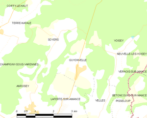
Guyonvelle
- commune in Haute-Marne, France
- Country:
- Postal Code: 52400
- Coordinates: 47° 51' 15" N, 5° 42' 28" E
- GPS tracks (wikiloc): [Link]
- Area: 5.34 sq km
- Population: 106


Voisey
- commune in Haute-Marne, France
- Country:
- Postal Code: 52400
- Coordinates: 47° 53' 4" N, 5° 46' 56" E
- GPS tracks (wikiloc): [Link]
- Area: 31.6 sq km
- Population: 297