
Strasbourg (Strasbourg)

- commune in Bas-Rhin, France
- Country:

- Postal Code: 67200; 67100; 67000
- Local Dialing Code: 368; 390; 388
- Coordinates: 48° 34' 24" N, 7° 45' 8" E


- GPS tracks (wikiloc): [Link]
- AboveSeaLevel: 143 м m
- Area: 78.26 sq km
- Population: 279284
- Web site: https://www.strasbourg.eu
- Wikipedia en: wiki(en)
- Wikipedia: wiki(fr)
- Wikidata storage: Wikidata: Q6602
- Wikipedia Commons Gallery: [Link]
- Wikipedia Commons Category: [Link]
- Wikipedia Commons Maps Category: [Link]
- Freebase ID: [/m/09b83]
- GeoNames ID: Alt: [2973783]
- SIREN number: [216704825]
- BnF ID: [15271624j]
- VIAF ID: Alt: [150696197]
- OSM relation ID: [71033]
- GND ID: Alt: [4057878-1]
- archINFORM location ID: [566]
- Library of Congress authority ID: Alt: [n79077528]
- PACTOLS thesaurus ID: [pcrtfT87QiFl82]
- MusicBrainz area ID: [153f5e62-2111-4c9e-9d4b-4c0b039bdf4f]
- Quora topic ID: [Strasbourg-France]
- TGN ID: [7012346]
- Encyclopædia Britannica Online ID: [place/Strasbourg]
- Gran Enciclopèdia Catalana ID: [0025387]
- Encyclopædia Universalis ID: [strasbourg]
- HDS ID: [6606]
- EMLO location ID: [0d580846-853d-451a-9252-a41c6466ea33]
- Facebook Places ID: [114470468564233]
- Twitter username: Alt: [strasbourg]
- Great Russian Encyclopedia Online ID: [4167974]
- ISNI: Alt: [0000 0001 2337 3844]
- NKCR AUT ID: [ge131549]
- DMOZ ID: Alt: [Regional/Europe/France/Regions/Alsace/Bas-Rhin/Localities/Strasbourg/]
- National Library of Israel ID: [000983722]
- YSO ID: [169016]
- Klexikon article ID: [Straßburg]
- NDL Auth ID: [00628641]
- UK Parliament thesaurus ID: [13075]
- INSEE municipality code: 67482
- US National Archives Identifier: 10045574
Shares border with regions:


Eckbolsheim
- commune in Bas-Rhin, France
- Country:
- Postal Code: 67201
- Coordinates: 48° 34' 44" N, 7° 41' 23" E
- GPS tracks (wikiloc): [Link]
- Area: 5.34 sq km
- Population: 6595

Ostwald
- commune in Bas-Rhin, France
- Country:
- Postal Code: 67540
- Coordinates: 48° 33' 4" N, 7° 42' 49" E
- GPS tracks (wikiloc): [Link]
- Area: 7.11 sq km
- Population: 12325
- Web site: [Link]


Lingolsheim
- commune in Bas-Rhin, France
- Country:
- Postal Code: 67380
- Coordinates: 48° 33' 27" N, 7° 40' 59" E
- GPS tracks (wikiloc): [Link]
- Area: 5.69 sq km
- Population: 18328
- Web site: [Link]


Oberhausbergen
- commune in Bas-Rhin, France
- Country:
- Postal Code: 67205
- Coordinates: 48° 36' 24" N, 7° 41' 7" E
- GPS tracks (wikiloc): [Link]
- Area: 3.79 sq km
- Population: 5207
- Web site: [Link]


Bischheim
- commune in Bas-Rhin, France
- Country:
- Postal Code: 67800
- Coordinates: 48° 36' 50" N, 7° 45' 7" E
- GPS tracks (wikiloc): [Link]
- Area: 4.41 sq km
- Population: 17188
- Web site: [Link]


La Wantzenau
- commune in Bas-Rhin, France
- Country:
- Postal Code: 67610
- Coordinates: 48° 39' 29" N, 7° 49' 42" E
- GPS tracks (wikiloc): [Link]
- Area: 25.39 sq km
- Population: 5768
- Web site: [Link]


Schiltigheim
- commune in Bas-Rhin, France
- Country:
- Postal Code: 67300
- Coordinates: 48° 36' 25" N, 7° 44' 57" E
- GPS tracks (wikiloc): [Link]
- Area: 7.63 sq km
- Population: 31767
- Web site: [Link]

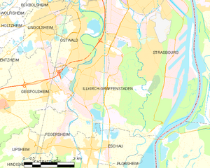
Illkirch-Graffenstaden
- commune in Bas-Rhin, France
- Country:
- Postal Code: 67400
- Coordinates: 48° 31' 29" N, 7° 42' 52" E
- GPS tracks (wikiloc): [Link]
- Area: 22.21 sq km
- Population: 26605
- Web site: [Link]


Eschau
- commune in Bas-Rhin, France
- Country:
- Postal Code: 67114
- Coordinates: 48° 29' 17" N, 7° 42' 57" E
- GPS tracks (wikiloc): [Link]
- Area: 11.83 sq km
- Population: 4984
- Web site: [Link]