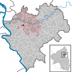
Sulzbach (Sulzbach)
- human settlement in Germany
Sulzbach, located in the Rhein-Lahn district of Germany, offers a variety of hiking opportunities that showcase the natural beauty of the region. The area is characterized by rolling hills, lush forests, and scenic views along the Lahn River.
Hiking Trails
-
Lahn Trail (Lahnwanderweg): This long-distance trail follows the Lahn River, providing a picturesque backdrop of riverbanks, woodlands, and charming villages. The section around Sulzbach offers both leisurely walks and more challenging hikes.
-
Round Walks: There are several circular routes around Sulzbach that typically range from 5 to 15 kilometers. These trails often include signage for easy navigation and lead through forests, fields, and past local landmarks.
-
Nature Reserve Paths: The nearby nature reserves may have designated trails that allow hikers to observe local wildlife and flora. These paths are often well-marked and maintained.
Tips for Hiking in Sulzbach
-
Difficulty Levels: Make sure to choose a hike that matches your fitness level. Many trails are well-suited for families and beginners, while some can be quite challenging.
-
Seasonal Considerations: Spring and fall are ideal times for hiking due to moderate temperatures and beautiful scenery. Be cautious in winter, as some paths may be icy or muddy.
-
Equipment: Wear appropriate hiking boots and bring plenty of water, snacks, and a map or a GPS device. A walking stick can be useful for more challenging terrain.
-
Local Information: Check with local tourism offices for updated trail information, maps, and recommendations. They can provide insights into the best spots to visit based on the season.
Local Attractions
After a day of hiking, consider exploring Sulzbach’s historical sites, such as the local church or nearby small towns. Enjoying a meal at a local restaurant can also be a great way to end your hiking adventure.
Hiking in Sulzbach, Rhein-Lahn, provides a delightful combination of natural beauty and cultural experiences. Always remember to respect the environment and follow local guidelines to preserve the trails for future hikers.
- Country:

- Postal Code: 56379
- Local Dialing Code: 02604
- Licence Plate Code: EMS
- Coordinates: 50° 18' 13" N, 7° 45' 12" E


- GPS tracks (wikiloc): [Link]
- AboveSeaLevel: 250 м m
- Area: 2.22 sq km
- Population: 197
- Web site: http://www.vgnassau.info
- Wikipedia en: wiki(en)
- Wikipedia: wiki(de)
- Wikidata storage: Wikidata: Q693212
- Wikipedia Commons Category: [Link]
- Freebase ID: [/m/02z3j18]
- GeoNames ID: Alt: [6554104]
- OSM relation ID: [540065]
- GND ID: Alt: [5331325-2]
- Historical Gazetteer (GOV) ID: [SULACH_W5409]
- German municipality key: 07141132

