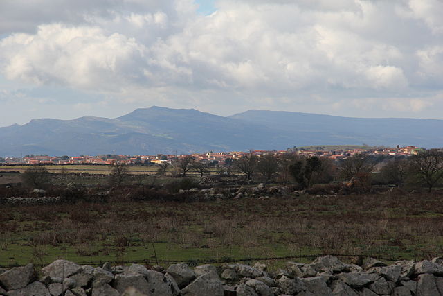
Suni, Sardinia (Suni)
%20-%202016.svg)
- Italian comune
 Hiking in Suni, Sardinia
Suni is a small village located in the beautiful region of Sardinia, Italy. While it may not be as widely known as some other destinations on the island, it offers excellent opportunities for hiking and outdoor exploration. Here are some highlights and tips for hiking in and around Suni:
Trails and Natural Features
-
Supramonte Mountain Range: Located not too far from Suni, the Supramonte offers breathtaking landscapes, rugged terrains, and a variety of hiking trails suitable for different skill levels. The area is famous for its limestone cliffs, deep gorges, and stunning vistas.
-
Oliena and Gola di Gorropu: A short drive from Suni, you can explore some of the most dramatic gorges in Sardinia. The Gola di Gorropu is often regarded as the Grand Canyon of Sardinia and is a must-visit for hikers looking for a challenge.
-
Forested Areas: The area surrounding Suni is covered with lush Mediterranean forests, offering a tranquil environment for hiking, bird-watching, and enjoying the diverse flora and fauna.
-
Local Trails: There may be marked trails closer to Suni that lead through olive groves, vineyards, and panoramic viewpoints. It's a good idea to consult local maps or visit a nearby tourist information center for guidance.
Useful Tips
-
Season: The best time to hike is during spring (April to June) and autumn (September to October) when the weather is mild, and the landscapes are vibrant with wildflowers or autumn colors.
-
Equipment: Wear sturdy hiking boots and bring plenty of water, snacks, and sun protection. A good map or GPS device can be very helpful in navigating the trails.
-
Cultural Considerations: As you hike, take time to appreciate local Sardinian culture, including traditional villages, local foods, and historic sites.
-
Leave No Trace: Remember to follow Leave No Trace principles to preserve the natural beauty of the area.
With its serene landscapes and diverse ecosystems, hiking in Suni and the surrounding areas is sure to offer a memorable experience for hikers of all levels. Enjoy your adventure in Sardinia!
- Country:

- Postal Code: 08010
- Local Dialing Code: 0785
- Licence Plate Code: OR
- Coordinates: 40° 16' 51" N, 8° 33' 1" E


- GPS tracks (wikiloc): [Link]
- AboveSeaLevel: 340 м m
- Area: 47.46 sq km
- Population: 1073
- Web site: http://www.comune.suni.or.it
- Wikipedia en: wiki(en)
- Wikipedia: wiki(it)
- Wikidata storage: Wikidata: Q388786
- Wikipedia Commons Gallery: [Link]
- Wikipedia Commons Category: [Link]
- Freebase ID: [/m/0gqwp4]
- GeoNames ID: Alt: [6537880]
- VIAF ID: Alt: [235741307]
- OSM relation ID: [40408]
- WOEID: [724638]
- ISTAT ID: 095087
- Italian cadastre code: L006
Shares border with regions:


Sagama
- Italian comune
Hiking in Sagama
Sagama, located in the beautiful mountainous regions of Japan, offers a variety of hiking trails that cater to different skill levels, from beginners to seasoned hikers. The region is known for its stunning landscapes, including lush forests, steep mountain paths, and breathtaking views....
- Country:
- Postal Code: 08010
- Local Dialing Code: 0785
- Licence Plate Code: OR
- Coordinates: 40° 15' 40" N, 8° 34' 39" E
- GPS tracks (wikiloc): [Link]
- AboveSeaLevel: 347 м m
- Area: 11.72 sq km
- Population: 199
- Web site: [Link]

Sindia, Sardinia
- Italian comune
Hiking in Sindia, Sardinia
Sardinia, an island in Italy, offers a wealth of stunning hiking opportunities, and Siniscola, located in the eastern part of the island, is a wonderful place to explore. Here are some highlights and tips for hiking in this area:...
- Country:
- Postal Code: 08018
- Local Dialing Code: 0785
- Licence Plate Code: NU
- Coordinates: 40° 17' 41" N, 8° 39' 27" E
- GPS tracks (wikiloc): [Link]
- AboveSeaLevel: 509 м m
- Area: 58.57 sq km
- Population: 1701
- Web site: [Link]


Bosa
- Italian comune
Hiking in Bosa
Bosa is a picturesque town located in the northwest of Sardinia, Italy, known for its colorful medieval buildings and stunning views of the surrounding landscapes. Hiking in and around Bosa offers a mix of breathtaking coastal vistas, lush countryside, and historical landmarks. Here’s an overview of what you can expect when hiking in this beautiful region:...
- Country:
- Postal Code: 08013
- Local Dialing Code: 0785
- Licence Plate Code: OR
- Coordinates: 40° 17' 56" N, 8° 29' 52" E
- GPS tracks (wikiloc): [Link]
- AboveSeaLevel: 5 м m
- Area: 128.02 sq km
- Population: 7927
- Web site: [Link]


Flussio
- Italian comune
Hiking in Flussio
Flussio is a small town located in the northern part of Sardinia, Italy. The region surrounding Flussio offers beautiful natural scenery and various hiking opportunities, ideal for both novice and experienced hikers. Here’s what you can expect when hiking in and around Flussio:...
- Country:
- Postal Code: 08010
- Local Dialing Code: 0785
- Licence Plate Code: OR
- Coordinates: 40° 16' 2" N, 8° 32' 21" E
- GPS tracks (wikiloc): [Link]
- AboveSeaLevel: 305 м m
- Area: 6.87 sq km
- Population: 433
- Web site: [Link]


Modolo
- Italian comune
Hiking in Modolo
Modolo is a charming village located in the region of Sardinia, Italy. It offers a picturesque setting for hiking enthusiasts due to its stunning natural landscapes, including rolling hills, lush forests, and panoramic views of the surrounding area....
- Country:
- Postal Code: 08019
- Local Dialing Code: 0785
- Licence Plate Code: OR
- Coordinates: 40° 16' 31" N, 8° 31' 48" E
- GPS tracks (wikiloc): [Link]
- AboveSeaLevel: 131 м m
- Area: 2.47 sq km
- Population: 163
- Web site: [Link]


Tinnura
- Italian comune
Hiking in Tinnura
Tinnura is a charming village located in the province of Nuoro, Sardinia, Italy, known for its scenic beauty and rich cultural heritage. Hiking in and around Tinnura offers a wonderful opportunity to explore the natural landscapes and enjoy stunning views of the coastline and the surrounding mountains....
- Country:
- Postal Code: 08010
- Local Dialing Code: 0785
- Licence Plate Code: OR
- Coordinates: 40° 16' 9" N, 8° 32' 53" E
- GPS tracks (wikiloc): [Link]
- AboveSeaLevel: 328 м m
- Area: 3.85 sq km
- Population: 242
- Web site: [Link]


Pozzomaggiore
- Italian comune
Hiking in Pozzomaggiore
Pozzomaggiore is a charming village located in the region of Sardinia, Italy, known for its stunning landscapes and hiking opportunities. The area is characterized by rugged mountains, dense forests, and picturesque rural scenery, offering a range of hikes suitable for different skill levels....
- Country:
- Postal Code: 07018
- Local Dialing Code: 079
- Licence Plate Code: SS
- Coordinates: 40° 23' 52" N, 8° 39' 35" E
- GPS tracks (wikiloc): [Link]
- AboveSeaLevel: 450 м m
- Area: 78.77 sq km
- Population: 2577
- Web site: [Link]