Talazac (Talazac)

- commune in Hautes-Pyrénées, France
- Country:

- Postal Code: 65500
- Coordinates: 43° 19' 58" N, 0° 2' 17" E


- GPS tracks (wikiloc): [Link]
- Area: 1.58 sq km
- Population: 72
- Wikipedia en: wiki(en)
- Wikipedia: wiki(fr)
- Wikidata storage: Wikidata: Q927565
- Wikipedia Commons Category: [Link]
- Freebase ID: [/m/03nv7hj]
- Freebase ID: [/m/03nv7hj]
- GeoNames ID: Alt: [6440936]
- GeoNames ID: Alt: [6440936]
- SIREN number: [216504381]
- SIREN number: [216504381]
- BnF ID: [15270868g]
- BnF ID: [15270868g]
- INSEE municipality code: 65438
- INSEE municipality code: 65438
Shares border with regions:

Saint-Lézer
- commune in Hautes-Pyrénées, France
- Country:
- Postal Code: 65500
- Coordinates: 43° 22' 7" N, 0° 1' 56" E
- GPS tracks (wikiloc): [Link]
- Area: 11.17 sq km
- Population: 417

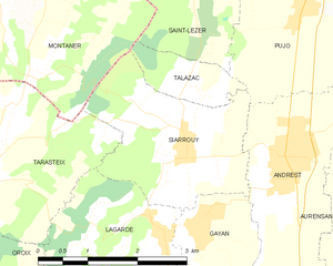
Siarrouy
- commune in Hautes-Pyrénées, France
- Country:
- Postal Code: 65500
- Coordinates: 43° 19' 15" N, 0° 2' 13" E
- GPS tracks (wikiloc): [Link]
- Area: 6.2 sq km
- Population: 434


Pujo
- commune in Hautes-Pyrénées, France
- Country:
- Postal Code: 65500
- Coordinates: 43° 20' 52" N, 0° 3' 57" E
- GPS tracks (wikiloc): [Link]
- Area: 5.28 sq km
- Population: 635
- Web site: [Link]


Montaner
- commune in Pyrénées-Atlantiques, France
- Country:
- Postal Code: 64460
- Coordinates: 43° 20' 44" N, 0° 0' 31" E
- GPS tracks (wikiloc): [Link]
- AboveSeaLevel: 240 м m
- Area: 19.13 sq km
- Population: 450