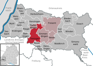
Teningen (Teningen)
- municipality in Baden-Württemberg, Germany
Teningen is a charming town in the Freiburg region of Baden-Württemberg, Germany, and is surrounded by beautiful natural landscapes perfect for hiking enthusiasts. The area offers various trails that cater to different skill levels, from easy walks to more challenging hikes.
Hiking Recommendations
-
Kandel Mountain:
- Just a short distance from Teningen, Kandel is one of the most popular hiking destinations in the Black Forest. You can hike to the summit for breathtaking views of the surrounding areas. The trails can be steep but are well-marked.
-
Nature Trails:
- Teningen has several well-marked nature trails that showcase the local flora and fauna. These trails are generally easy and perfect for families or beginners.
-
The Gurtweiler Trail:
- This trail offers a pleasant loop through scenic countryside, vineyards, and orchards. It is particularly enjoyable in the fall when the foliage changes color.
-
Regional Park Trails:
- The surrounding region has designated parks with lengthy trails that offer a mix of forest paths and vineyard walks. These trails often have rest areas and viewpoints.
Tips for Hiking in Teningen
-
Weather Preparedness: Always check the weather before heading out, as conditions can change rapidly in the mountains.
-
Footwear: Sturdy, comfortable hiking boots are essential, especially for steep or rocky trails.
-
Hydration and Nutrition: Carry enough water and snacks, as some trails may lack facilities.
-
Navigation: While trails are generally well-marked, bringing a map or GPS device is helpful, especially for longer or less familiar hikes.
-
Local Guides: Consider hiring a guide or joining local hiking groups for a more enriching experience, as they can provide insights into the area's history and ecology.
Hiking in and around Teningen offers a great way to experience the beautiful landscapes of Baden-Württemberg while enjoying the peace of nature. Happy hiking!
- Country:

- Postal Code: 79331
- Local Dialing Code: 07663; 07641
- Licence Plate Code: EM
- Coordinates: 48° 7' 46" N, 7° 48' 43" E


- GPS tracks (wikiloc): [Link]
- AboveSeaLevel: 188 м m
- Area: 40.27 sq km
- Population: 11596
- Web site: http://www.teningen.de
- Wikipedia en: wiki(en)
- Wikipedia: wiki(de)
- Wikidata storage: Wikidata: Q539862
- Wikipedia Commons Category: [Link]
- Freebase ID: [/m/0dx368]
- GeoNames ID: Alt: [2823504]
- VIAF ID: Alt: [244542127]
- OSM relation ID: [1124271]
- GND ID: Alt: [4059457-9]
- archINFORM location ID: [10790]
- WOEID: [698842]
- Quora topic ID: [Teningen]
- Gran Enciclopèdia Catalana ID: [0465575]
- Historical Gazetteer (GOV) ID: [TENGENJN38VD]
- German municipality key: 08316043

