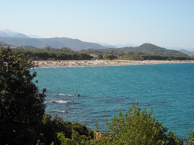
Tertenia (Tertenia)
%20-%202016.svg)
- Italian comune
 Hiking in Tertenia
Tertenia is a picturesque town located on the eastern coast of Sardinia, Italy. It's surrounded by stunning landscapes that offer excellent opportunities for hiking enthusiasts. Here are some key points about hiking in and around Tertenia:
Trails and Natural Beauty
-
Diverse Terrain: The area features a mix of coastal trails, hills, and rugged landscapes that provide various difficulty levels for hikers. You can experience lush forests, rocky paths, and cliffside views of the Mediterranean Sea.
-
Cala dei Turchi: This beautiful beach is accessible via hiking paths, and the views along the way are breathtaking. The trail provides an opportunity to enjoy the natural beauty of sandy and rocky coastlines.
-
Monte Comuni: This mountain offers more challenging hikes. The ascent rewards trekkers with panoramic views of the surrounding area, including the coast and distant mountains.
-
Flora and Fauna: The region is rich in biodiversity. Hikers may encounter various plant species, as well as local wildlife, including birds and perhaps even a glimpse of native mammals.
Hiking Tips
- Best Time to Hike: The ideal months for hiking in Tertenia are usually from late spring to early autumn (April to October), when the weather is generally mild and pleasant.
- Gear: Good hiking boots are essential due to rocky and uneven terrain. Don’t forget to bring plenty of water, snacks, and sun protection, as some trails can be exposed to the sun.
- Local Guides: If you're unfamiliar with the area or prefer a structured experience, consider hiring a local guide for a more in-depth exploration of the trails and local culture.
Cultural Aspects
Tertenia offers not just amazing hiking opportunities but also a glimpse into Sardinian culture. After a day of trekking, you can explore the town, enjoy local cuisine, and perhaps visit historical sites and churches.
Conclusion
Whether you're an experienced hiker or a beginner, Tertenia offers beautiful landscapes and trails suitable for all abilities. Always check local trail maps and guidelines, and prepare adequately for a safe and enjoyable hike.
- Country:

- Postal Code: 08047
- Local Dialing Code: 0782
- Licence Plate Code: NU
- Coordinates: 39° 41' 47" N, 9° 34' 44" E


- GPS tracks (wikiloc): [Link]
- AboveSeaLevel: 129 м m
- Area: 117.65 sq km
- Population: 3927
- Web site: http://www.comunetertenia.it/
- Wikipedia en: wiki(en)
- Wikipedia: wiki(it)
- Wikidata storage: Wikidata: Q340611
- Wikipedia Commons Category: [Link]
- Freebase ID: [/m/0gqwpw]
- Freebase ID: [/m/0gqwpw]
- GeoNames ID: Alt: [6537881]
- GeoNames ID: Alt: [6537881]
- VIAF ID: Alt: [245418886]
- VIAF ID: Alt: [245418886]
- OSM relation ID: [40012]
- OSM relation ID: [40012]
- GND ID: Alt: [4664843-4]
- GND ID: Alt: [4664843-4]
- UN/LOCODE: [ITTNU]
- UN/LOCODE: [ITTNU]
- Digital Atlas of the Roman Empire ID: [32837]
- Digital Atlas of the Roman Empire ID: [32837]
- ISTAT ID: 091089
- ISTAT ID: 091089
- Italian cadastre code: L140
- Italian cadastre code: L140
Shares border with regions:


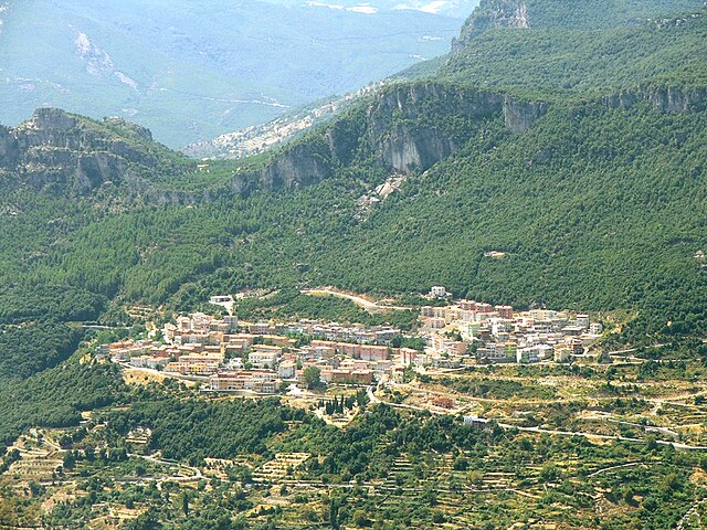
Lanusei
- Italian comune
Hiking in Lanusei
Lanusei, located in the Ogliastra region of Sardinia, Italy, is a fantastic destination for hiking enthusiasts. The area offers a combination of stunning landscapes, diverse flora and fauna, and rich cultural heritage. Here are some highlights and tips for hiking in and around Lanusei:...
- Country:
- Postal Code: 08045
- Local Dialing Code: 0782
- Licence Plate Code: NU
- Coordinates: 39° 52' 43" N, 9° 32' 29" E
- GPS tracks (wikiloc): [Link]
- AboveSeaLevel: 595 м m
- Area: 53.17 sq km
- Population: 5387
- Web site: [Link]

Cardedu
- Italian comune
Hiking in Cardedu
Cardedu, located on the eastern coast of Sardinia, Italy, offers beautiful landscapes and a variety of hiking opportunities. The area is known for its stunning coastal views, pristine beaches, and rugged terrain, making it a perfect destination for hikers of all skill levels....
- Country:
- Postal Code: 08040
- Local Dialing Code: 0782
- Licence Plate Code: NU
- Coordinates: 39° 47' 48" N, 9° 37' 36" E
- GPS tracks (wikiloc): [Link]
- AboveSeaLevel: 49 м m
- Area: 33.39 sq km
- Population: 1928
- Web site: [Link]


Gairo, Sardinia
- Italian comune
Hiking in Gairo, Sardinia
Gairo, a small village in Sardinia, Italy, is known for its stunning landscapes, rugged terrain, and rich cultural heritage, making it a fantastic destination for hiking enthusiasts. Here are some highlights of hiking in Gairo:...
- Country:
- Postal Code: 08040
- Local Dialing Code: 0782
- Licence Plate Code: NU
- Coordinates: 39° 50' 47" N, 9° 30' 24" E
- GPS tracks (wikiloc): [Link]
- AboveSeaLevel: 690 м m
- Area: 77.49 sq km
- Population: 1412
- Web site: [Link]


Jerzu
- Italian comune
Hiking in Jerzu
Jerzu is a picturesque town located in the heart of Sardinia, Italy, known for its stunning natural landscape, rich culture, and outdoor activities, particularly hiking. The area surrounding Jerzu offers a variety of trails that cater to different skill levels, making it an excellent destination for hikers of all abilities....
- Country:
- Postal Code: 08044
- Local Dialing Code: 0782
- Licence Plate Code: NU
- Coordinates: 39° 47' 33" N, 9° 31' 4" E
- GPS tracks (wikiloc): [Link]
- AboveSeaLevel: 427 м m
- Area: 102.61 sq km
- Population: 3177
- Web site: [Link]
Loceri
- Italian comune
Hiking in Loceri
Loceri is a small village located in the province of Nuoro in Sardinia, Italy. The surrounding area is characterized by beautiful landscapes, including rolling hills, mountains, and a rich mix of flora and fauna, making it a great destination for hiking enthusiasts....
- Country:
- Postal Code: 08040
- Local Dialing Code: 0782
- Licence Plate Code: NU
- Coordinates: 39° 51' 27" N, 9° 34' 59" E
- GPS tracks (wikiloc): [Link]
- AboveSeaLevel: 206 м m
- Area: 19.37 sq km
- Population: 1298
- Web site: [Link]

Osini
- Italian comune
Hiking in Osini
Osini, located in Sardinia, Italy, is a charming and lesser-known destination for hikers. This area is characterized by its stunning landscapes, rich history, and unique geological features, including limestone cliffs and beautiful coves. Here’s what you might want to know about hiking in Osini:...
- Country:
- Postal Code: 08040
- Local Dialing Code: 0782
- Licence Plate Code: NU
- Coordinates: 39° 49' 21" N, 9° 29' 48" E
- GPS tracks (wikiloc): [Link]
- AboveSeaLevel: 645 м m
- Area: 39.81 sq km
- Population: 776
- Web site: [Link]


Ulassai
- Italian comune
Hiking in Ulassai
Ulassai, located in the province of Ogliastra in Sardinia, Italy, is known for its breathtaking landscapes and rich natural beauty, making it a fantastic destination for hiking enthusiasts. Here are some key points about hiking in Ulassai:...
- Country:
- Postal Code: 08040
- Local Dialing Code: 0782
- Licence Plate Code: NU
- Coordinates: 39° 48' 42" N, 9° 29' 56" E
- GPS tracks (wikiloc): [Link]
- AboveSeaLevel: 775 м m
- Area: 122.41 sq km
- Population: 1448
- Web site: [Link]