Tournières (Tournières)

- commune in Calvados, France
- Country:

- Postal Code: 14330
- Coordinates: 49° 14' 0" N, 0° 55' 48" E


- GPS tracks (wikiloc): [Link]
- Area: 3.41 sq km
- Population: 153
- Wikipedia en: wiki(en)
- Wikipedia: wiki(fr)
- Wikidata storage: Wikidata: Q226718
- Wikipedia Commons Category: [Link]
- Freebase ID: [/m/03_rfm]
- GeoNames ID: Alt: [6427527]
- SIREN number: [211407051]
- BnF ID: [15248113k]
- INSEE municipality code: 14705
Shares border with regions:


Sainte-Marguerite-d'Elle
- commune in Calvados, France
- Country:
- Postal Code: 14330
- Coordinates: 49° 12' 26" N, 1° 1' 17" E
- GPS tracks (wikiloc): [Link]
- Area: 20.49 sq km
- Population: 767

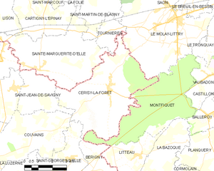
Cerisy-la-Forêt
- commune in Manche, France
- Country:
- Postal Code: 50680
- Coordinates: 49° 11' 42" N, 0° 56' 12" E
- GPS tracks (wikiloc): [Link]
- Area: 23.81 sq km
- Population: 979


Le Molay-Littry
- commune in Calvados, France
- Country:
- Postal Code: 14330
- Coordinates: 49° 14' 33" N, 0° 52' 23" E
- GPS tracks (wikiloc): [Link]
- Area: 27.12 sq km
- Population: 3053
- Web site: [Link]

Saint-Martin-de-Blagny
- commune in Calvados, France
- Country:
- Postal Code: 14710
- Coordinates: 49° 15' 5" N, 0° 56' 52" E
- GPS tracks (wikiloc): [Link]
- Area: 8.89 sq km
- Population: 132