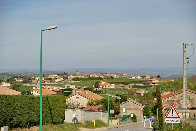
Tournon-sur-Rhône (Tournon-sur-Rhône)
- commune in Ardèche, France
 Hiking in Tournon-sur-Rhône
Tournon-sur-Rhône, located in the Auvergne-Rhône-Alpes region of France, is an excellent starting point for hikers interested in exploring the stunning landscapes of the Rhône Valley and the surrounding area. Here’s a guide to hiking in this picturesque town and its surroundings:
Hiking Trails
-
Col de l'Escrinet:
- This area offers several trails with varying difficulty levels. The routes provide breathtaking views of the surrounding hills and vineyards. The ascent is moderate, and the trails are well-marked.
-
Les Chemins de Traverse:
- A network of hiking paths that connect Tournon to neighboring villages and scenic viewpoints. This is a great way to explore the local countryside, with opportunities to see vineyards and historic sites along the way.
-
La ViaRhôna:
- This is a long-distance cycling and walking route along the Rhône River from Lake Geneva to the Mediterranean. Parts of it run close to Tournon and offer a flat, easy hike along the river with beautiful views.
-
Mont Pilat Regional Natural Park:
- Just a short drive from Tournon, this park offers more challenging hiking opportunities. The trails vary from easy walks to more strenuous hikes with steep climbs, leading to stunning vistas of the Rhône Valley and the surrounding mountains.
Nature and Scenery
Hiking around Tournon-sur-Rhône provides beautiful landscapes, including vineyards, rivers, and rolling hills. The region is known for its wine production, particularly the famous Syrah grapes grown in the nearby Hermitage and Côte Rôtie appellations.
Local Wildlife
Expect to encounter a diverse range of flora and fauna while hiking, including various bird species and native plants. The proximity to the Rhône River also offers chances to observe riverine ecosystems.
Best Times to Hike
- Spring (April to June): Mild temperatures and blooming wildflowers make this an ideal time for hiking.
- Autumn (September to November): The fall foliage adds a beautiful backdrop to your hikes, and the weather is still relatively mild.
Hiking Tips
- Water and Snacks: Always bring enough water and snacks, especially on longer hikes.
- Appropriate Gear: Wear sturdy hiking shoes and dress in layers, as temperatures can vary.
- Map and GPS: Familiarize yourself with trail maps and have a GPS or compass for navigation.
- Local Guides: If you're new to the area or wanting to learn more about the local flora and fauna, consider hiring a local guide.
Conclusion
Hiking in and around Tournon-sur-Rhône offers a wonderful way to experience the region’s natural beauty and rich heritage. Whether you’re looking for a leisurely stroll or a challenging hike, you’ll find plenty of options to enjoy the great outdoors.
- Country:

- Postal Code: 07300
- Coordinates: 45° 4' 2" N, 4° 49' 58" E


- GPS tracks (wikiloc): [Link]
- AboveSeaLevel: 123 м m
- Area: 21.01 sq km
- Population: 10326
- Web site: http://www.ville-tournon.com
- Wikipedia en: wiki(en)
- Wikipedia: wiki(fr)
- Wikidata storage: Wikidata: Q213155
- Wikipedia Commons Category: [Link]
- Freebase ID: [/m/08pxm0]
- GeoNames ID: Alt: [2972214]
- SIREN number: [210703245]
- BnF ID: [119343755]
- VIAF ID: Alt: [141170566]
- Library of Congress authority ID: Alt: [nr95037046]
- PACTOLS thesaurus ID: [pcrtGRXomYP0Km]
- MusicBrainz area ID: [0b0d196f-1a7d-40ff-a1d8-8d0b2413819a]
- Quora topic ID: [Tournon-sur-Rhône]
- SUDOC authorities ID: [034725075]
- EMLO location ID: [13d6b0bb-1ac0-42bc-8ab3-98a2da46b65e]
- INSEE municipality code: 07324
Shares border with regions:


Mercurol
- former commune in Drôme, France
Hiking in Mercurol
Mercurol, located in the Auvergne-Rhône-Alpes region of France, is a small commune known primarily for its beautiful landscapes, vineyards, and proximity to the Rhône River. While it may not be as famous for hiking as some other areas in the region, it offers several opportunities for outdoor activities, including hiking....
- Country:
- Postal Code: 26600
- Coordinates: 45° 4' 34" N, 4° 53' 27" E
- GPS tracks (wikiloc): [Link]
- Area: 20.82 sq km
- Population: 2245
- Web site: [Link]


La Roche-de-Glun
- commune in Drôme, France
Hiking in La Roche-de-Glun
La Roche-de-Glun, located in the Drôme department of the Auvergne-Rhône-Alpes region in southeastern France, offers various hiking opportunities that highlight its natural beauty and scenic landscapes. Here are some key points about hiking in this area:...
- Country:
- Postal Code: 26600
- Coordinates: 45° 0' 43" N, 4° 50' 51" E
- GPS tracks (wikiloc): [Link]
- Area: 12.79 sq km
- Population: 3258
- Web site: [Link]
Saint-Barthélemy-le-Plain
- commune in Ardèche, France
- Country:
- Postal Code: 07300
- Coordinates: 45° 3' 16" N, 4° 44' 48" E
- GPS tracks (wikiloc): [Link]
- Area: 19.08 sq km
- Population: 822

Plats
- commune in Ardèche, France
- Country:
- Postal Code: 07300
- Coordinates: 45° 0' 36" N, 4° 46' 56" E
- GPS tracks (wikiloc): [Link]
- Area: 16.25 sq km
- Population: 843
- Web site: [Link]

Mauves
- commune in Ardèche, France
Hiking in Mauves
Mauves is a picturesque village located in the Rhône-Alpes region of France, surrounded by stunning landscapes and natural beauty, making it a great destination for hiking enthusiasts. Here are some highlights of hiking in and around Mauves:...
- Country:
- Postal Code: 07300
- Coordinates: 45° 2' 18" N, 4° 49' 46" E
- GPS tracks (wikiloc): [Link]
- Area: 7.05 sq km
- Population: 1171

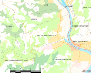
Saint-Jean-de-Muzols
- commune in Ardèche, France
- Country:
- Postal Code: 07300
- Coordinates: 45° 4' 54" N, 4° 48' 50" E
- GPS tracks (wikiloc): [Link]
- Area: 10.68 sq km
- Population: 2391


Tain-l'Hermitage, Drôme
- commune in Drôme, France
Hiking in Tain-l'Hermitage, Drôme
Tain-l'Hermitage, located in the Rhône-Alpes region of France, is surrounded by beautiful landscapes and scenic trails that make it a great destination for hiking enthusiasts. Here are a few highlights and tips for hiking in the area:...
- Country:
- Postal Code: 26600
- Coordinates: 45° 4' 14" N, 4° 50' 33" E
- GPS tracks (wikiloc): [Link]
- Area: 4.85 sq km
- Population: 6100
- Web site: [Link]