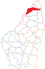
arrondissement of Tournon-sur-Rhône (arrondissement de Tournon-sur-Rhône)

- arrondissement of France
 Hiking in arrondissement of Tournon-sur-Rhône
The Arrondissement of Tournon-sur-Rhône, located in the Auvergne-Rhône-Alpes region of southeastern France, offers some fantastic hiking opportunities, showcasing the beautiful landscapes of the Rhone Valley, vineyards, and the surrounding mountains.
Key Hiking Areas:
-
Vercors Regional Natural Park:
- Just to the west, this park offers a range of trails through its stunning limestone mountains.
- Hikes vary from easy walks to challenging treks, often with incredible views.
-
Ardèche Gorges:
- Located to the south, the gorges provide breathtaking scenery.
- Various trails lead along the cliffs and riverbanks, showcasing the dramatic landscape and rich wildlife.
-
Monts d’Ardèche Regional Natural Park:
- Offers a range of hiking options with diverse terrain, including forests, waterfalls, and volcanic landscapes.
- The trails cater to various skill levels and lengths, perfect for a day hike or a longer excursion.
Tips for Hiking in the Area:
- Prepare for Varying Weather: The weather can change rapidly, particularly in mountainous areas, so be prepared with the right clothing and gear.
- Stay Hydrated: Always carry enough water, especially during warmer months.
- Trail Maps: It’s recommended to carry a map or use a hiking app to stay on the right track. Trails are usually well-marked, but it’s good to have a backup.
- Respect Nature: Follow Leave No Trace principles to protect the natural environment while enjoying the trails.
- Local Guides: Consider hiring a local guide for unique insights into the area's natural history and culture.
Highlights:
- Beautiful Vineyards: The region is known for its wine production, so some trails may take you through picturesque vineyards where you can taste local wines.
- Historical Sites: Some trails might lead you to historical ruins or charming villages, adding to the hiking experience.
Conclusion:
Hiking in the Arrondissement of Tournon-sur-Rhône is rewarding with its rich natural beauty and variety of trails. Whether you’re an experienced hiker or just looking for a scenic walk, this region is a great destination for outdoor enthusiasts. Remember to plan accordingly and enjoy the vistas along the way!
- Country:

- Capital: Tournon-sur-Rhône
- Coordinates: 45° 5' 0" N, 4° 35' 0" E


- GPS tracks (wikiloc): [Link]
- Area: 1858 sq km
- Population: 138206
- Wikipedia en: wiki(en)
- Wikipedia: wiki(fr)
- Wikidata storage: Wikidata: Q702655
- Freebase ID: [/m/095hl7]
- GeoNames ID: Alt: [2972212]
- INSEE arrondissement code: [073]
- GNS Unique Feature ID: -1473269
Includes regions:

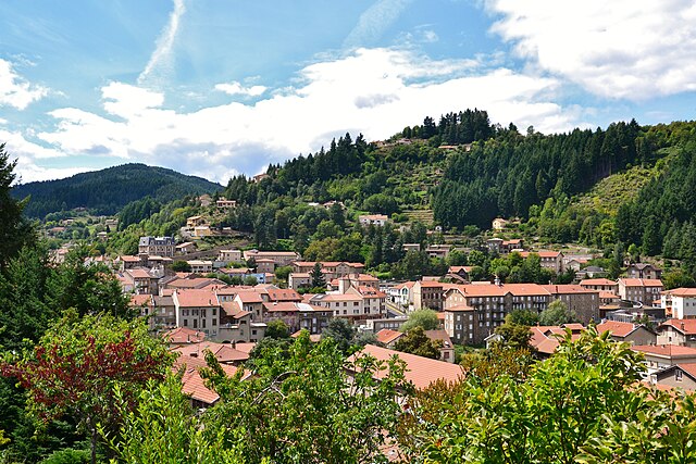
canton of Saint-Agrève
- canton of France (until March 2015)
- Country:
- Capital: Saint-Agrève
- Coordinates: 45° 1' 0" N, 4° 24' 0" E
- GPS tracks (wikiloc): [Link]

canton of Haut-Eyrieux
- canton of France
- Country:
- Capital: Le Cheylard
- Coordinates: 44° 54' 22" N, 4° 25' 23" E
- GPS tracks (wikiloc): [Link]
- Population: 18317


canton of Vernoux-en-Vivarais
- canton of France
- Country:
- Capital: Vernoux-en-Vivarais
- Coordinates: 44° 54' 0" N, 4° 39' 0" E
- GPS tracks (wikiloc): [Link]

canton of Saint-Martin-de-Valamas
- French canton
- Country:
- Capital: Saint-Martin-de-Valamas
- Coordinates: 44° 56' 17" N, 4° 22' 10" E
- GPS tracks (wikiloc): [Link]
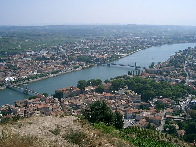

canton of Tournon-sur-Rhône
- canton of France
Hiking in canton of Tournon-sur-Rhône
The Canton of Tournon-sur-Rhône, located in the Auvergne-Rhône-Alpes region of France, offers a variety of hiking opportunities that cater to different skill levels and preferences. This picturesque area is characterized by its beautiful landscapes, vineyards, and proximity to the Rhône River, making it an ideal destination for outdoor enthusiasts....
- Country:
- Capital: Tournon-sur-Rhône
- Coordinates: 45° 4' 0" N, 4° 50' 0" E
- GPS tracks (wikiloc): [Link]
- Population: 20641

canton of Saint-Félicien
- canton of France (until March 2015)
- Country:
- Capital: Saint-Félicien
- Coordinates: 45° 5' 12" N, 4° 37' 41" E
- GPS tracks (wikiloc): [Link]


canton of Haut-Vivarais
- canton of France
- Country:
- Capital: Lamastre
- Coordinates: 44° 59' 0" N, 4° 35' 0" E
- GPS tracks (wikiloc): [Link]
- Population: 21283
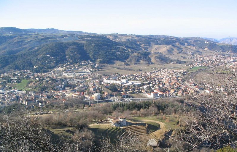
canton of Saint-Péray
- canton of France (until March 2015)
Hiking in canton of Saint-Péray
Canton de Saint-Péray, located in the Ardèche department of France, offers beautiful landscapes and diverse hiking opportunities. The region is characterized by its stunning views of the Rhône Valley, vineyards, and the surrounding hills. Here are some highlights for hiking in this area:...
- Country:
- Capital: Saint-Péray
- Coordinates: 44° 57' 0" N, 4° 50' 0" E
- GPS tracks (wikiloc): [Link]