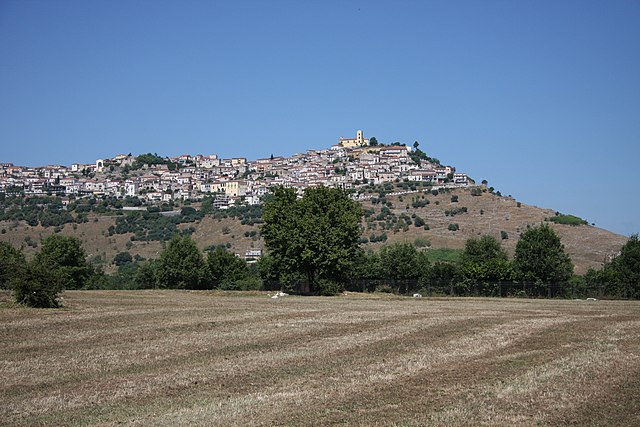
Tramutola (Tramutola)
.svg)
- Italian comune
 Hiking in Tramutola
Tramutola is a charming village located in the Basilicata region of southern Italy, known for its scenic landscapes and rich natural beauty, making it an excellent destination for hiking enthusiasts. Here are some highlights and tips for hiking in and around Tramutola:
Natural Landscapes
- Mounts and Hills: The area surrounding Tramutola features rolling hills and nearby mountainous terrains, offering a variety of trails with varying levels of difficulty.
- Cascading Streams: As you hike, you may encounter beautiful streams and rivers that enhance the pristine natural scenery.
- Flora and Fauna: The region is home to diverse plant and animal species, providing opportunities for nature observation and photography.
Popular Hiking Trails
- Sentiero degli Alpini: This path provides beautiful views of the surrounding valleys, ideal for both experienced hikers and beginners.
- Paths in the Gallipoli Cognato Forest: This nearby national park offers well-marked trails through forests of beech and fir, showcasing the area's biodiversity.
Hiking Tips
- Best Time to Go: The optimal time for hiking in Tramutola is during the spring (April to June) and fall (September to October), when temperatures are milder and nature is at its most vibrant.
- Gear Up: Ensure you have appropriate hiking gear, including sturdy footwear, weather-appropriate clothing, and adequate supplies of water and snacks.
- Maps and Guides: Having a good map or a local guide can enhance your hiking experience, helping you navigate the various trails and discover hidden gems.
- Respect the Environment: Always follow Leave No Trace principles to preserve the natural beauty of the area for future hikers.
Local Culture and Cuisine
While hiking, take the opportunity to enjoy the local culture in Tramutola. Engage with the friendly locals, and don't miss out on trying traditional Lucanian dishes, which often feature hearty ingredients like legumes, meats, and homemade pasta.
Safety
Ensure you check the weather forecast before heading out and inform someone about your hiking plan. If you're unfamiliar with the area, consider joining a guided hike to enhance safety and knowledge.
Hiking in Tramutola can be a peaceful and enriching experience, allowing you to connect with nature and enjoy the picturesque Italian countryside. Enjoy your adventure!
- Country:

- Postal Code: 85057
- Local Dialing Code: 0975
- Licence Plate Code: PZ
- Coordinates: 40° 19' 0" N, 15° 47' 0" E


- GPS tracks (wikiloc): [Link]
- AboveSeaLevel: 650 м m
- Area: 36.65 sq km
- Population: 3033
- Web site: http://www.comune.tramutola.pz.it
- Wikipedia en: wiki(en)
- Wikipedia: wiki(it)
- Wikidata storage: Wikidata: Q52686
- Wikipedia Commons Category: [Link]
- Freebase ID: [/m/0fh40d]
- GeoNames ID: Alt: [6539017]
- VIAF ID: Alt: [308730143]
- OSM relation ID: [40410]
- MusicBrainz area ID: [f0dd88fc-9dad-4188-8c2c-f7b8edc5e992]
- WOEID: [725188]
- ISTAT ID: 076091
- Italian cadastre code: L326
Shares border with regions:

Grumento Nova
- Italian comune
Hiking in Grumento Nova
Grumento Nova, located in the Basilicata region of southern Italy, is an excellent destination for hiking enthusiasts. The area is rich in natural beauty, offering stunning landscapes, historical sites, and a variety of trails suitable for different skill levels. Here are some highlights for hiking in and around Grumento Nova:...
- Country:
- Postal Code: 85050
- Local Dialing Code: 0975
- Licence Plate Code: PZ
- Coordinates: 40° 17' 2" N, 15° 53' 23" E
- GPS tracks (wikiloc): [Link]
- AboveSeaLevel: 771 м m
- Area: 66.65 sq km
- Population: 1694
- Web site: [Link]


Marsicovetere
- Italian comune
Hiking in Marsicovetere
Marsicovetere, located in the Basilicata region of southern Italy, offers a variety of hiking opportunities amidst beautiful landscapes, rich history, and charming villages. The area is characterized by its rolling hills, scenic valleys, and proximity to the Appennine Mountains, making it an attractive destination for outdoor enthusiasts....
- Country:
- Postal Code: 85050
- Local Dialing Code: 0975
- Licence Plate Code: PZ
- Coordinates: 40° 22' 28" N, 15° 49' 34" E
- GPS tracks (wikiloc): [Link]
- AboveSeaLevel: 1037 м m
- Area: 38.01 sq km
- Population: 5531
- Web site: [Link]


Moliterno
- Italian comune
Hiking in Moliterno
Moliterno is a small town in the Basilicata region of Southern Italy, nestled in the Appennine mountains. The area around Moliterno is known for its stunning natural landscapes, which provide excellent opportunities for hiking and outdoor activities....
- Country:
- Postal Code: 85047
- Local Dialing Code: 0975
- Licence Plate Code: PZ
- Coordinates: 40° 14' 24" N, 15° 51' 36" E
- GPS tracks (wikiloc): [Link]
- AboveSeaLevel: 879 м m
- Area: 98.55 sq km
- Population: 3916
- Web site: [Link]


Paterno
- Italian comune in the Basilicata region
Hiking in Paterno
Paterno, located in the Basilicata region of southern Italy, is a lesser-known gem for hiking enthusiasts. The region is characterized by its stunning landscapes, rich history, and diverse wildlife, making it a unique destination for outdoor activities....
- Country:
- Postal Code: 85050
- Local Dialing Code: 0975
- Licence Plate Code: PZ
- Coordinates: 40° 23' 0" N, 15° 44' 0" E
- GPS tracks (wikiloc): [Link]
- AboveSeaLevel: 634 м m
- Area: 40.74 sq km
- Population: 3327
- Web site: [Link]


Montesano sulla Marcellana
- Italian comune
Hiking in Montesano sulla Marcellana
Montesano sulla Marcellana is a charming town located in the province of Salerno in the Campania region of Italy. Nestled in the heart of the Cilento National Park, the area is rich in natural beauty, making it an excellent destination for hiking enthusiasts. Here are some key aspects to consider for hiking in and around Montesano sulla Marcellana:...
- Country:
- Postal Code: 84033
- Local Dialing Code: 0975
- Licence Plate Code: SA
- Coordinates: 40° 17' 0" N, 15° 42' 0" E
- GPS tracks (wikiloc): [Link]
- AboveSeaLevel: 850 м m
- Area: 110.22 sq km
- Population: 6544
- Web site: [Link]
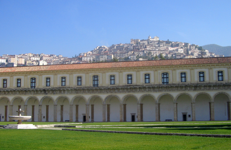

Padula
- Italian comune
Hiking in Padula
Padula, located in the province of Salerno in the Campania region of Italy, is famous not only for its rich history and culture but also for its stunning natural landscape that offers excellent hiking opportunities. Here are some key points about hiking in and around Padula:...
- Country:
- Postal Code: 84030; 84034
- Local Dialing Code: 0975
- Licence Plate Code: SA
- Coordinates: 40° 20' 20" N, 15° 39' 23" E
- GPS tracks (wikiloc): [Link]
- AboveSeaLevel: 699 м m
- Area: 67.12 sq km
- Population: 5377
- Web site: [Link]