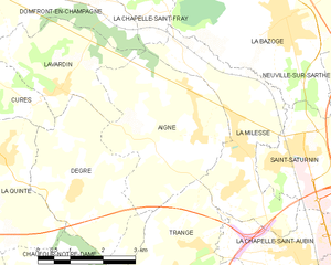
Trangé (Trangé)

- commune in Sarthe, France
- Country:

- Postal Code: 72650
- Coordinates: 48° 1' 36" N, 0° 6' 40" E


- GPS tracks (wikiloc): [Link]
- Area: 11.11 sq km
- Population: 1356
- Wikipedia en: wiki(en)
- Wikipedia: wiki(fr)
- Wikidata storage: Wikidata: Q1226355
- Wikipedia Commons Category: [Link]
- Freebase ID: [/m/03qk_vk]
- SIREN number: [217203603]
- INSEE municipality code: 72360
Shares border with regions:


La Chapelle-Saint-Aubin
- commune in Sarthe, France
- Country:
- Postal Code: 72650
- Coordinates: 48° 2' 7" N, 0° 9' 38" E
- GPS tracks (wikiloc): [Link]
- Area: 5.93 sq km
- Population: 2398


Fay
- commune in Sarthe, France
- Country:
- Postal Code: 72550
- Coordinates: 48° 0' 29" N, 0° 4' 14" E
- GPS tracks (wikiloc): [Link]
- Area: 9.48 sq km
- Population: 617
- Web site: [Link]

Aigné
- commune in Sarthe, France
- Country:
- Postal Code: 72650
- Coordinates: 48° 4' 1" N, 0° 7' 8" E
- GPS tracks (wikiloc): [Link]
- Area: 12.59 sq km
- Population: 1627
- Web site: [Link]

Le Mans
- commune in Sarthe, France
- Country:
- Postal Code: 72100; 72000
- Coordinates: 48° 0' 15" N, 0° 11' 49" E
- GPS tracks (wikiloc): [Link]
- AboveSeaLevel: 51 м m
- Area: 52.81 sq km
- Population: 143325
- Web site: [Link]


Pruillé-le-Chétif
- commune in Sarthe, France
- Country:
- Postal Code: 72700
- Coordinates: 47° 59' 34" N, 0° 6' 31" E
- GPS tracks (wikiloc): [Link]
- Area: 10.3 sq km
- Population: 1322
- Web site: [Link]


Rouillon
- commune in Sarthe, France
- Country:
- Postal Code: 72700
- Coordinates: 48° 0' 27" N, 0° 8' 10" E
- GPS tracks (wikiloc): [Link]
- Area: 9.15 sq km
- Population: 2304
- Web site: [Link]


La Milesse
- commune in Sarthe, France
- Country:
- Postal Code: 72650
- Coordinates: 48° 3' 53" N, 0° 8' 8" E
- GPS tracks (wikiloc): [Link]
- Area: 10.41 sq km
- Population: 2617
- Web site: [Link]


Chaufour-Notre-Dame
- commune in Sarthe, France
- Country:
- Postal Code: 72550
- Coordinates: 48° 1' 31" N, 0° 4' 30" E
- GPS tracks (wikiloc): [Link]
- Area: 11.19 sq km
- Population: 1059