
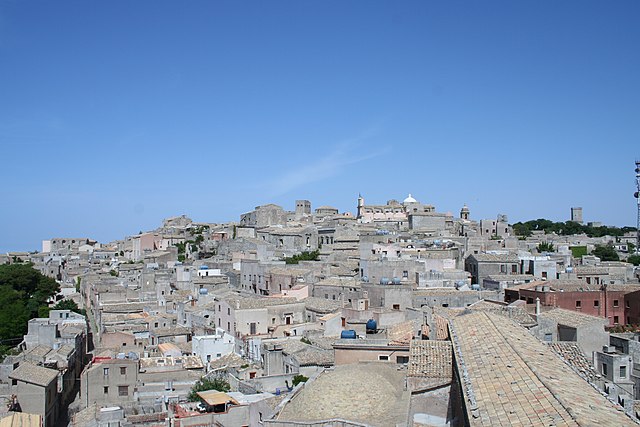
Trapani (Trapani)
.svg)
- Italian comune
 Hiking in Trapani
Trapani is a beautiful coastal city located on the northwest coast of Sicily, Italy. It offers a rich variety of hiking opportunities that allow you to experience the stunning landscapes, unique geological formations, and beautiful Mediterranean scenery. Here are some highlights for hiking in and around Trapani:
1.
- Location: Just a short drive from Trapani, near the village of Custonaci.
- Hiking Trails: The trails in Monte Cofano provide breathtaking views of the coastline and surrounding mountains. The reserve features a mix of coastal paths and inland trails, with wildlife sightings and historic sites, such as the ancient ruins of a defensive watchtower.
- Difficulty: Moderate; suitable for most hikers.
2.
- Location: A bit farther from Trapani, between Scopello and San Vito lo Capo.
- Features: This reserve is famous for its rugged coastline, crystal-clear waters, and diverse flora and fauna. The hiking path traverses the reserve along the coast, offering access to beautiful beaches and stunning vistas.
- Difficulty: Moderate; ensure to carry enough water as there are limited facilities.
3.
- Location: A medieval hilltop town near Trapani.
- Hiking Trail: You can hike up to Erice from Trapani, taking the winding paths that offer expansive views over the Gulf of Trapani. The area is rich in history, with many ancient buildings and ruins to explore once you reach the top.
- Difficulty: Moderate to challenging, depending on the chosen path.
4.
- Description: A unique area where you can hike along salt pans, observing traditional salt harvesting methods and diverse birdlife, including flamingos.
- Difficulty: Easy; mostly flat paths, ideal for a leisurely stroll.
5.
- Location: A stunning white limestone cliff located further east of Trapani, close to Agrigento.
- Hiking Opportunities: While not a traditional hiking area, you can walk along the beach to admire the rock formations and coastal scenery. It's a great spot for photography.
- Difficulty: Easy; mainly beach access.
- Weather: Always check the weather conditions before heading out, as temperatures can vary, especially in summer.
- Gear: Wear appropriate hiking shoes, bring plenty of water, snacks, sun protection, and a map or GPS device.
- Local Guidance: Consider hiring a local guide for more in-depth knowledge of the area and for safety.
The best times for hiking in Trapani are during spring (April to June) and fall (September to October) when the weather is mild and the landscapes are particularly beautiful.
Enjoy your hiking adventures in Trapani, and don't forget to take in the stunning views along the way!
- Country:

- Postal Code: 91100
- Local Dialing Code: 0923
- Licence Plate Code: TP
- Coordinates: 38° 1' 0" N, 12° 31' 0" E


- GPS tracks (wikiloc): [Link]
- AboveSeaLevel: 3 м m
- Area: 273.13 sq km
- Population: 67923
- Web site: http://www.comune.trapani.it
- Wikipedia en: wiki(en)
- Wikipedia: wiki(it)
- Wikidata storage: Wikidata: Q13664
- Wikipedia Commons Gallery: [Link]
- Wikipedia Commons Category: [Link]
- Wikipedia Commons Maps Category: [Link]
- Freebase ID: [/m/0c63w]
- GeoNames ID: Alt: [6542155]
- BnF ID: [119646988]
- VIAF ID: Alt: [153613527]
- OSM relation ID: [39404]
- GND ID: Alt: [4249472-2]
- archINFORM location ID: [6926]
- Library of Congress authority ID: Alt: [n81043335]
- PACTOLS thesaurus ID: [pcrtSEvuuiYN2x]
- MusicBrainz area ID: [ece8412e-3090-4c0a-a434-f61bab22e32c]
- Quora topic ID: [Trapani]
- UN/LOCODE: [ITTPS]
- Encyclopædia Britannica Online ID: [place/Trapani]
- EMLO location ID: [0d42159b-979d-4c23-ad77-ec09188bd6d3]
- DMOZ ID: Alt: [Regional/Europe/Italy/Regions/Sicily/Localities/Trapani/]
- ISTAT ID: 081021
- Italian cadastre code: L331
- US National Archives Identifier: 10044882
Shares border with regions:

Erice
- Italian comune
Hiking in Erice
Erice, a charming medieval town located in Sicily, Italy, offers some fantastic hiking opportunities with breathtaking views and diverse landscapes. Here are some highlights and tips for hiking in and around Erice:...
- Country:
- Postal Code: 91016
- Local Dialing Code: 0923
- Licence Plate Code: TP
- Coordinates: 38° 2' 15" N, 12° 35' 15" E
- GPS tracks (wikiloc): [Link]
- AboveSeaLevel: 751 м m
- Area: 47.34 sq km
- Population: 27655
- Web site: [Link]


Marsala
- Italian comune
Hiking in Marsala
Marsala, located in the western part of Sicily, Italy, is known for its stunning landscapes, rich history, and delicious wines. While Marsala itself may not be a traditional hiking destination, it serves as an excellent base for exploring the surrounding natural areas and trails. Here are some key points about hiking near Marsala:...
- Country:
- Postal Code: 91025
- Local Dialing Code: 0923
- Licence Plate Code: TP
- Coordinates: 37° 47' 58" N, 12° 26' 4" E
- GPS tracks (wikiloc): [Link]
- AboveSeaLevel: 3 м m
- Area: 243.26 sq km
- Population: 82802
- Web site: [Link]


Buseto Palizzolo
- Italian comune
Hiking in Buseto Palizzolo
Buseto Palizzolo is a charming village located in the province of Trapani in Sicily, Italy. It offers a variety of hiking opportunities that showcase the natural beauty and cultural heritage of the area. Here are some key aspects to consider when hiking in and around Buseto Palizzolo:...
- Country:
- Postal Code: 91012
- Local Dialing Code: 0923
- Licence Plate Code: TP
- Coordinates: 38° 1' 0" N, 12° 44' 0" E
- GPS tracks (wikiloc): [Link]
- AboveSeaLevel: 249 м m
- Area: 72.81 sq km
- Population: 2928
- Web site: [Link]


Calatafimi-Segesta
- Italian comune
Hiking in Calatafimi-Segesta
Calatafimi-Segesta, located in Sicily, Italy, is a fantastic destination for hiking enthusiasts. This area is rich in natural beauty, archaeological sites, and historical significance. Here are some key aspects of hiking in Calatafimi-Segesta:...
- Country:
- Postal Code: 91013
- Local Dialing Code: 0924
- Licence Plate Code: TP
- Coordinates: 37° 54' 0" N, 12° 51' 0" E
- GPS tracks (wikiloc): [Link]
- AboveSeaLevel: 338 м m
- Area: 154.86 sq km
- Population: 6537
- Web site: [Link]


Paceco
- Italian comune
Hiking in Paceco
Paceco is a charming area located in Sicily, Italy, known for its natural beauty and proximity to the stunning landscapes of the Sicilian countryside, as well as the nearby Egadi Islands and the beautiful coastline. Here’s an overview of what you can expect when hiking in and around Paceco:...
- Country:
- Postal Code: 91027
- Local Dialing Code: 0923
- Licence Plate Code: TP
- Coordinates: 37° 59' 0" N, 12° 33' 0" E
- GPS tracks (wikiloc): [Link]
- AboveSeaLevel: 36 м m
- Area: 58.01 sq km
- Population: 11307
- Web site: [Link]


Salemi
- Italian comune
Hiking in Salemi
Salemi, a charming town located in Sicily, Italy, offers a unique blend of history, culture, and natural beauty that makes it an excellent destination for hiking enthusiasts. Here are some highlights and tips for hiking in and around Salemi:...
- Country:
- Postal Code: 91018
- Local Dialing Code: 0924
- Licence Plate Code: TP
- Coordinates: 37° 49' 19" N, 12° 48' 18" E
- GPS tracks (wikiloc): [Link]
- AboveSeaLevel: 446 м m
- Area: 182.42 sq km
- Population: 10647
- Web site: [Link]


Valderice
- Italian comune
Hiking in Valderice
Valderice, situated in Sicily, Italy, is a beautiful area that offers a range of hiking opportunities. Nestled between the coastline and the mountains, this region provides hikers with stunning views, diverse landscapes, and a chance to explore the rich natural and cultural heritage of the area. Here are some key points about hiking in Valderice:...
- Country:
- Postal Code: 91019
- Local Dialing Code: 0923
- Licence Plate Code: TP
- Coordinates: 38° 3' 0" N, 12° 37' 0" E
- GPS tracks (wikiloc): [Link]
- AboveSeaLevel: 240 м m
- Area: 52.96 sq km
- Population: 12253
- Web site: [Link]