Trichiana (Trichiana)
- Italian hamlet
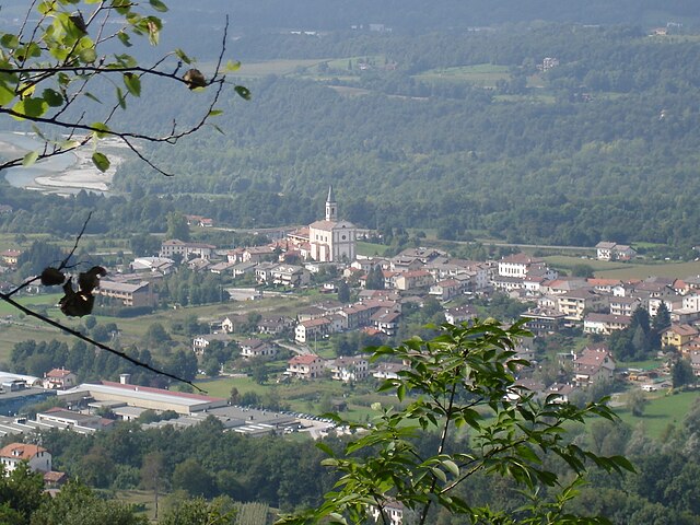
Trichiana is a picturesque village located in the Veneto region of Italy, near the foothills of the Dolomites. This area is known for its stunning natural beauty, making it an excellent destination for hiking enthusiasts. Here are some details about hiking in and around Trichiana:
Trail Options
-
Local Trails: There are numerous well-marked trails around Trichiana, suitable for hikers of various skill levels. These trails often lead through lush forests, along rivers, and up to panoramic viewpoints.
-
Dolomites Hiking: Since Trichiana is in proximity to the Dolomites, more challenging hikes can be accessed with a bit of travel. The stunning rock formations, alpine meadows, and diverse flora and fauna make the Dolomites a hiker's paradise.
-
Via Ferrata: For the more adventurous, nearby regions offer via ferrata routes, which are protected climbing paths that allow hikers to explore steep and rocky terrains safely.
Recommended Hikes
- Sentiero dell'Acqua: This is a particularly charming trail that follows water courses, providing breathtaking views of waterfalls and the surrounding landscape.
- Col Visentin: A hike that can be started from Trichiana leading to the summit of Col Visentin, offering fantastic panoramic views of the surrounding valleys and mountains.
Best Time to Hike
- Spring and Fall: These seasons generally offer the best weather for hiking, with mild temperatures and fewer crowds.
- Summer: Ideal for experiencing vibrant greenery and blooming wildflowers, though it can get crowded on popular trails.
- Winter: While some trails may be open, caution is advised due to snow and ice.
Tips for Hiking in Trichiana
- Footwear: Wear sturdy hiking boots for support and traction.
- Clothing: Dress in layers to accommodate changing temperatures, especially in mountainous areas.
- Hydration and Nutrition: Always carry enough water and snacks for your hike.
- Navigation: Although trails are often well-marked, it’s good practice to carry a map or GPS device.
- Local Regulations: Respect local wildlife and adhere to any guidelines regarding trail usage.
Hiking in Trichiana offers a blend of natural beauty and local culture, providing a memorable experience for outdoor enthusiasts. Whether you're a beginner or an experienced hiker, there's something for everyone in this stunning part of Italy. Enjoy your hike!
- Country:

- Postal Code: 32028
- Local Dialing Code: 0437
- Licence Plate Code: BL
- Coordinates: 46° 4' 28" N, 12° 8' 4" E


- GPS tracks (wikiloc): [Link]
- AboveSeaLevel: 347 м m
- Area: 43.96 sq km
- Population: 4820
- Web site: http://trichiana.valbelluna.bl.it/
- Wikipedia en: wiki(en)
- Wikipedia: wiki(it)
- Wikidata storage: Wikidata: Q40468
- Wikipedia Commons Category: [Link]
- Freebase ID: [/m/0gk2dc]
- GeoNames ID: Alt: [6538289]
- VIAF ID: Alt: [245452787]
- OSM relation ID: [46721]
- archINFORM location ID: [46096]
- WOEID: [15000353]
- UN/LOCODE: [ITTHA]
- ISTAT ID: 025061
- Italian cadastre code: L422
Shares border with regions:


Limana
- Italian comune
Limana is a charming town located in the Province of Belluno in the Veneto region of northern Italy, nestled near the foothills of the Dolomites. This area is known for its stunning landscapes, rich natural beauty, and a network of hiking trails suitable for various skill levels....
- Country:

- Postal Code: 32020
- Local Dialing Code: 0437
- Licence Plate Code: BL
- Coordinates: 46° 6' 0" N, 12° 11' 0" E


- GPS tracks (wikiloc): [Link]
- AboveSeaLevel: 364 м m
- Area: 39.12 sq km
- Population: 5335
- Web site: [Link]


Revine Lago
- Italian comune
Revine Lago, located in the beautiful region of Treviso in Italy, is a fantastic destination for hiking enthusiasts. Nestled between the stunning hills and surrounded by lush forests, Revine Lago offers a variety of trails that cater to different skill levels, all set against the backdrop of scenic views and serene lakes....
- Country:

- Postal Code: 31020
- Local Dialing Code: 0438
- Licence Plate Code: TV
- Coordinates: 45° 59' 4" N, 12° 12' 6" E


- GPS tracks (wikiloc): [Link]
- AboveSeaLevel: 225 м m
- Area: 18.79 sq km
- Population: 2162
- Web site: [Link]

