Tripleville (Tripleville)

- former commune in Loir-et-Cher, France
- Country:

- Postal Code: 41240
- Coordinates: 47° 56' 37" N, 1° 29' 10" E


- GPS tracks (wikiloc): [Link]
- Area: 13.07 sq km
- Population: 170
- Wikipedia en: wiki(en)
- Wikipedia: wiki(fr)
- Wikidata storage: Wikidata: Q765516
- Wikipedia Commons Category: [Link]
- Freebase ID: [/m/03nw2v_]
- GeoNames ID: Alt: [2971657]
- BnF ID: [15259538g]
- INSEE municipality code: 41264
Shares border with regions:

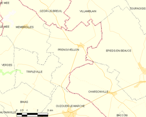
Prénouvellon
- former commune in Loir-et-Cher, France
- Country:
- Postal Code: 41240
- Coordinates: 47° 58' 8" N, 1° 32' 19" E
- GPS tracks (wikiloc): [Link]
- Area: 19.77 sq km
- Population: 244

Binas
- commune in Loir-et-Cher, France
- Country:
- Postal Code: 41240
- Coordinates: 47° 54' 12" N, 1° 27' 45" E
- GPS tracks (wikiloc): [Link]
- Area: 26.38 sq km
- Population: 727
Verdes
- former commune in Loir-et-Cher, France
- Country:
- Postal Code: 41240
- Coordinates: 47° 57' 29" N, 1° 25' 45" E
- GPS tracks (wikiloc): [Link]
- Area: 28.59 sq km
- Population: 462


Membrolles
- former commune in Loir-et-Cher, France
- Country:
- Postal Code: 41240
- Coordinates: 47° 59' 5" N, 1° 28' 2" E
- GPS tracks (wikiloc): [Link]
- Area: 18.95 sq km
- Population: 268