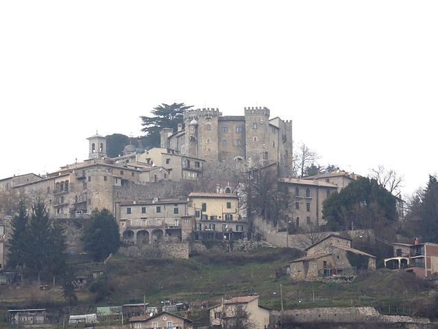
Turania (Turania)
.svg)
- Italian comune
 Hiking in Turania
Turania, known for its stunning landscapes and rich biodiversity, offers an array of hiking opportunities for outdoor enthusiasts. While it's not one of the most famous hiking destinations, it can provide a unique experience, especially for those looking to explore natural beauty away from the typical trails.
Hiking Features in Turania:
-
Scenic Trails: The region boasts a variety of trails that vary in difficulty. You can find easier, well-marked paths suitable for families and beginners, as well as challenging routes for experienced hikers looking for adventure.
-
Natural Landscapes: Hikers can expect to encounter lush forests, open meadows, and spectacular views of distant mountains. Wildlife is abundant, making it a great spot for birdwatching and nature photography.
-
Cultural Experience: Hiking in Turania can also provide insights into local culture and communities. You may come across traditional villages and have the opportunity to interact with locals, which can enrich your hiking experience.
-
Seasonality: Spring and fall are ideal times to hike in Turania, as temperatures are mild, and the scenery is particularly beautiful with blooming flowers or autumn foliage. Summer can get hot, and winters may bring snow, making some trails difficult or inaccessible.
-
Preparation and Safety: Always prepare adequately before embarking on a hike. Research trail conditions, pack sufficient water and snacks, wear appropriate footwear, and check the weather forecast. It's advisable to inform someone of your hiking plans, particularly if you are going into less-trafficked areas.
-
Guided Tours: If you’re unfamiliar with the area or prefer a more structured experience, consider joining a guided hiking tours. Local guides can provide you with information about the flora and fauna, as well as ensure your safety.
Conclusion
Hiking in Turania can be a breathtaking experience, offering a blend of natural beauty and cultural richness. Whether you are seeking solitude or a family-friendly adventure, the trails in this region present a wonderful opportunity for exploration in the great outdoors. Remember to respect the environment by following Leave No Trace principles and enjoy your hike!
- Country:

- Postal Code: 02020
- Local Dialing Code: 0765
- Licence Plate Code: RI
- Coordinates: 42° 8' 0" N, 13° 1' 0" E


- GPS tracks (wikiloc): [Link]
- AboveSeaLevel: 703 м m
- Area: 8.51 sq km
- Population: 238
- Web site: http://www.halleyegov.it/c057071/hh/index.php?jvs=0&acc=1
- Wikipedia en: wiki(en)
- Wikipedia: wiki(it)
- Wikidata storage: Wikidata: Q224705
- Wikipedia Commons Category: [Link]
- Freebase ID: [/m/0gm6kh]
- GeoNames ID: Alt: [6536935]
- VIAF ID: Alt: [248720696]
- OSM relation ID: [41793]
- ISTAT ID: 057071
- Italian cadastre code: G507
Shares border with regions:

Collalto Sabino
- Italian comune
Hiking in Collalto Sabino
Collalto Sabino, located in the Province of Rieti in the Lazio region of Italy, offers a range of beautiful hiking opportunities set in a stunning natural landscape. Here are some highlights of hiking in this area:...
- Country:
- Postal Code: 02022
- Local Dialing Code: 0765
- Licence Plate Code: RI
- Coordinates: 42° 8' 12" N, 13° 2' 54" E
- GPS tracks (wikiloc): [Link]
- AboveSeaLevel: 980 м m
- Area: 22.37 sq km
- Population: 416
- Web site: [Link]
Collegiove
- Italian comune
Hiking in Collegiove
Collegiove is a picturesque village located in the Lazio region of Italy, nestled within the beautiful landscape of the Apennine Mountains. This area is known for its natural beauty, making it a great destination for hiking enthusiasts. Here are some highlights for hiking in Collegiove:...
- Country:
- Postal Code: 02020
- Local Dialing Code: 0765
- Licence Plate Code: RI
- Coordinates: 42° 11' 0" N, 13° 2' 0" E
- GPS tracks (wikiloc): [Link]
- AboveSeaLevel: 1001 м m
- Area: 10.61 sq km
- Population: 150
- Web site: [Link]


Pozzaglia Sabina
- Italian comune
Hiking in Pozzaglia Sabina
Pozzaglia Sabina is a picturesque village located in the Sabina region of Italy, known for its beautiful natural landscapes, rolling hills, and rich history. The area is perfect for hiking enthusiasts due to its varied terrain and scenic views. Here are some key points to consider for hiking in Pozzaglia Sabina:...
- Country:
- Postal Code: 02030
- Local Dialing Code: 0765
- Licence Plate Code: RI
- Coordinates: 42° 10' 0" N, 12° 58' 0" E
- GPS tracks (wikiloc): [Link]
- AboveSeaLevel: 878 м m
- Area: 24.98 sq km
- Population: 331
- Web site: [Link]


Vivaro Romano
- Italian comune
Hiking in Vivaro Romano
Vivaro Romano is a charming town located in the province of Rome, Italy, surrounded by stunning landscapes and natural beauty, making it a fantastic destination for hiking enthusiasts....
- Country:
- Postal Code: 00020
- Local Dialing Code: 0774
- Licence Plate Code: RM
- Coordinates: 42° 6' 2" N, 13° 0' 27" E
- GPS tracks (wikiloc): [Link]
- AboveSeaLevel: 756 м m
- Area: 12.54 sq km
- Population: 158
- Web site: [Link]


Carsoli
- Italian comune
Hiking in Carsoli
Carsoli, located in the Abruzzo region of Italy, offers some beautiful hiking opportunities amidst its picturesque landscapes, rich history, and diverse flora and fauna. Here are some highlights and tips for hiking in and around Carsoli:...
- Country:
- Postal Code: 67061
- Local Dialing Code: 0863
- Licence Plate Code: AQ
- Coordinates: 42° 5' 56" N, 13° 5' 19" E
- GPS tracks (wikiloc): [Link]
- AboveSeaLevel: 616 м m
- Area: 95.8 sq km
- Population: 5314
- Web site: [Link]