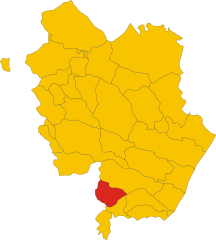
Tursi (Tursi)
.svg)
- Italian comune
 Hiking in Tursi
Tursi is a charming town located in the Basilicata region of Southern Italy, known for its rich history and beautiful landscapes. While it may not be as well-known as some other hiking destinations in Italy, Tursi and its surrounding areas offer some lovely opportunities for outdoor enthusiasts.
Hiking Opportunities in Tursi
-
Pollino National Park: Located a short drive from Tursi, Pollino National Park is the largest protected natural area in Italy. It features dramatic mountain ranges, deep gorges, and diverse flora and fauna. There are numerous trails for various skill levels, from easy walks to challenging hikes. The park is also home to the famous Loricate Pine, which is a unique species found in this region.
-
Rivers and Streams: Tursi is situated near the Sinni River, which provides opportunities for scenic hikes alongside the riverbanks and through the surrounding countryside. You can enjoy the serenity of the water and the lush landscapes that characterize the area.
-
Historic Trails: Exploring the historic pathways that connect Tursi with nearby villages and ancient ruins can be rewarding. Some trails may lead you through picturesque olive groves, vineyards, and rocky terrains, providing a glimpse into the region's agricultural heritage.
-
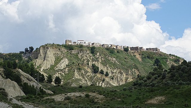
The Ancient City of Tursi: Within the town itself, you can hike through the narrow streets of Tursi, observing its historic architecture, churches, and the well-known "Civita" district, which is perched on a hill and offers stunning views of the surrounding valley.
Tips for Hiking in Tursi
-
Check Trail Conditions: Before heading out, check local maps and trail conditions, as some paths may be less maintained.
-
Gear Up: Wear appropriate footwear and clothing, and carry a good backpack with water, snacks, and a first-aid kit.
-
Respect Nature: As with any hiking experience, remember to follow Leave No Trace principles, which include staying on marked trails and respecting wildlife.
-
Local Guidance: Consider contacting local hiking groups or guides who can help you navigate the area and discover hidden gems along the trails.
-
Seasonal Considerations: The best time to hike in this region is during the spring and fall when the weather is mild. Summer can be hot, and winter may lead to snow in higher elevations.
Hiking in Tursi allows you to experience both natural beauty and rich cultural heritage, making for a memorable outdoor adventure.
- Country:

- Postal Code: 75028
- Local Dialing Code: 0835
- Licence Plate Code: MT
- Coordinates: 40° 15' 0" N, 16° 28' 0" E


- GPS tracks (wikiloc): [Link]
- AboveSeaLevel: 243 м m
- Area: 159.93 sq km
- Population: 4981
- Web site: http://www.comune.tursi.mt.it
- Wikipedia en: wiki(en)
- Wikipedia: wiki(it)
- Wikidata storage: Wikidata: Q52337
- Wikipedia Commons Gallery: [Link]
- Wikipedia Commons Category: [Link]
- Freebase ID: [/m/0fgv6f]
- Freebase ID: [/m/0fgv6f]
- GeoNames ID: Alt: [6539028]
- GeoNames ID: Alt: [6539028]
- BnF ID: [13514907h]
- BnF ID: [13514907h]
- VIAF ID: Alt: [123236875]
- VIAF ID: Alt: [123236875]
- OSM relation ID: [40359]
- OSM relation ID: [40359]
- GND ID: Alt: [4373562-9]
- GND ID: Alt: [4373562-9]
- ISTAT ID: 077029
- ISTAT ID: 077029
- Italian cadastre code: L477
- Italian cadastre code: L477
Shares border with regions:

Colobraro
- Italian comune
Hiking in Colobraro
Colobraro is a small hilltop village located in the Basilicata region of southern Italy, known for its stunning landscapes, historical charm, and various hiking opportunities. While it may not be as widely recognized as some other hiking destinations in Italy, it offers a unique experience for those looking to explore serene trails and enjoy nature....
- Country:
- Postal Code: 75021
- Local Dialing Code: 0835
- Licence Plate Code: MT
- Coordinates: 40° 11' 0" N, 16° 26' 0" E
- GPS tracks (wikiloc): [Link]
- AboveSeaLevel: 630 м m
- Area: 66.61 sq km
- Population: 1203
- Web site: [Link]

Montalbano Jonico
- Italian comune
Hiking in Montalbano Jonico
Montalbano Jonico, located in the Basilicata region of Italy, is a charming town that offers beautiful landscapes and opportunities for hiking enthusiasts. The area is characterized by rolling hills, stunning views, and a rich natural environment that includes vineyards, olive groves, and Mediterranean vegetation....
- Country:
- Postal Code: 75023
- Local Dialing Code: 0835
- Licence Plate Code: MT
- Coordinates: 40° 17' 0" N, 16° 34' 0" E
- GPS tracks (wikiloc): [Link]
- AboveSeaLevel: 292 м m
- Area: 136 sq km
- Population: 7208
- Web site: [Link]


Policoro
- Italian comune
Hiking in Policoro
Policoro, located in the Basilicata region of southern Italy, offers a unique mix of natural beauty, history, and Mediterranean landscapes, making it a great spot for hiking enthusiasts. Here are some key points to consider when hiking in and around Policoro:...
- Country:
- Postal Code: 75025
- Local Dialing Code: 0835
- Licence Plate Code: MT
- Coordinates: 40° 12' 0" N, 16° 40' 0" E
- GPS tracks (wikiloc): [Link]
- AboveSeaLevel: 25 м m
- Area: 67.66 sq km
- Population: 17694
- Web site: [Link]
Rotondella
- Italian comune
Hiking in Rotondella
Rotondella is a charming town located in the Basilicata region of Italy, known for its beautiful landscapes and rich history. When it comes to hiking in and around Rotondella, there are several aspects to consider:...
- Country:
- Postal Code: 75026
- Local Dialing Code: 0835
- Licence Plate Code: MT
- Coordinates: 40° 10' 0" N, 16° 31' 0" E
- GPS tracks (wikiloc): [Link]
- AboveSeaLevel: 576 м m
- Area: 76.72 sq km
- Population: 2592
- Web site: [Link]
Scanzano Jonico
- Italian comune
Hiking in Scanzano Jonico
Scanzano Jonico, located in the Basilicata region of southern Italy, is primarily known for its beautiful coastline along the Ionian Sea, but it also offers several opportunities for hiking and exploring the surrounding landscape. While the area may not be as famous for hiking as other regions in Italy, there are still some noteworthy trails and natural areas to consider:...
- Country:
- Postal Code: 75020
- Local Dialing Code: 0835
- Licence Plate Code: MT
- Coordinates: 40° 15' 0" N, 16° 42' 0" E
- GPS tracks (wikiloc): [Link]
- AboveSeaLevel: 21 м m
- Area: 72.18 sq km
- Population: 7624
- Web site: [Link]


Stigliano
- Italian comune
Hiking in Stigliano
Stigliano is a charming town located in the Basilicata region of southern Italy, known for its beautiful landscapes and opportunities for outdoor activities, including hiking. While the town might not be as famous as some other Italian hiking destinations, it offers a unique experience for outdoor enthusiasts who are looking to explore scenic trails and enjoy nature....
- Country:
- Postal Code: 75018
- Local Dialing Code: 0835
- Licence Plate Code: MT
- Coordinates: 40° 24' 9" N, 16° 13' 47" E
- GPS tracks (wikiloc): [Link]
- AboveSeaLevel: 909 м m
- Area: 211.15 sq km
- Population: 4112
- Web site: [Link]
Sant'Arcangelo
- Italian comune
Hiking in Sant'Arcangelo
Sant'Arcangelo, located in the Basilicata region of Italy, is known for its beautiful landscapes, rich history, and charming architecture. Hiking in this area can be a rewarding experience, offering stunning views and opportunities to explore the natural and cultural heritage of the region....
- Country:
- Postal Code: 85037
- Local Dialing Code: 0973
- Licence Plate Code: PZ
- Coordinates: 40° 14' 55" N, 16° 16' 14" E
- GPS tracks (wikiloc): [Link]
- AboveSeaLevel: 388 м m
- Area: 89.1 sq km
- Population: 6448
- Web site: [Link]